Trail Walking Aragnouet - Rando tour des Lacs de Néouvielle - Photo

Rando tour des Lacs de Néouvielle

 Fab-Oz
Fab-Oz

User

© OpenStreetMap contributors
Length
Length
14.1 km
Max alt
Max alt
2460 m
Uphill gradient
Uphill gradient
732 m
Km-Effort
Km-Effort  
24 km
Min alt
Min alt
1847 m
Downhill gradient
Downhill gradient
742 m
Boucle
Boucle
Yes
Creation date :
2022-07-21 08:54:07.162
Updated on :
2022-07-21 14:30:14.896

(0 Reviews)

Walking
Walking
4h50
Difficulty : Medium

Scan this QR Code to open this trail in the SityTrail application

FREE GPS app for hiking

Logo SityTrail SityTrail

IGN / Geographical institutes

Download SityTrail from the App Store Download SityTrail from Google Play

Logo SityTrail SityTrail World

The world is yours!

Download SityTrail from the App Store Download SityTrail from Google Play Download SityTrail on Huawei AppGallery

About

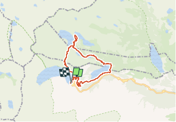
Trail Walking of 14.1 km to be discovered at Occitania, Hautespyrenees, Aragnouet. This trail is proposed by Fab-Oz.

Description

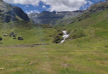
Circuit au départ du barrage du lac de Cap de long.
Le début de rando est le plus difficile, après le barrage, pour monter jusqu'au Pas de Gat, puis la descente jusqu'au Lac d'Aubert. Ensuite, la balade est vraiment sympa et facile, en passant par les Lacs d'Aumar, les Laquettes, puis en descente jusqu'au Lac d'Orédon.
La remontée jusqu'au Cap de Long par le sentier est très sympa, facile et progressive. La fin par les escaliers et les échelles, en contrebas du barrage, peut être évité en prenant la route.

Elevation profile

Photos

Positioning

Country:
France
Region :
Occitania
Department/Province :
Hautespyrenees
Municipality :
Aragnouet
Location:
Unknown
Start:(UTM)
266296 ; 4744735 (31T) N.

Trails nearby

Trail Walking Barèges - Refuge de Glère brèche de Chaussenque Pic de Neouvielle, lac d'Oredon - Photo
Walking
reneperrin

Walking

Difficult
(1)
Barèges, Occitania, Hautespyrenees, France
16.2 km | 31 km-effort
5h 58min
No
Trail Walking Aragnouet - Pic d'Estaragne et Pic Cambieil - Photo
Walking
tracegps

Walking

Very difficult
(2)
Aragnouet, Occitania, Hautespyrenees, France
11.6 km | 28 km-effort
3h 40min
Yes
Trail Walking Saint-Lary-Soulan - Le soum de Monpelat par les laquettes (Néouvielle) - Photo
Walking
tracegps

Walking

Difficult
(2)
Saint-Lary-Soulan, Occitania, Hautespyrenees, France
11.5 km | 21 km-effort
3h 10min
Yes
Trail Walking Aragnouet - Pic Barrosa, Soum Barrosa et Pic de Port de Vieux - Photo
Walking
tracegps

Walking

Very difficult
(1)
Aragnouet, Occitania, Hautespyrenees, France
22 km | 42 km-effort
9h 0min
Yes
Trail Walking Aragnouet - Lac de Barroude par Aragnouet - Photo
Walking
tracegps

Walking

Difficult
(1)
Aragnouet, Occitania, Hautespyrenees, France
8.2 km | 18.3 km-effort
3h 0min
No
Trail Walking Aragnouet - Hourquettes de Héas et de Chermentas en boucle depuis Piau Engaly - Photo
Walking
2041

Walking

Medium
(3)
Aragnouet, Occitania, Hautespyrenees, France
12.4 km | 25 km-effort
5h 3min
Yes
Trail Walking Aragnouet - M005-Circuit Barroude-Port Vieux - Photo
Walking
Polo-31

Walking

Difficult
(1)
Aragnouet, Occitania, Hautespyrenees, France
22 km | 41 km-effort
8h 11min
Yes
Trail Walking Saint-Lary-Soulan - Lac d''Oredon - lac d''Aubert - Photo
Walking
faust1959

Walking

Very easy
(1)
Saint-Lary-Soulan, Occitania, Hautespyrenees, France
4.2 km | 7.4 km-effort
Unknown
No
Trail Walking Aragnouet - Lac du Badet par les cascades  - Photo
Walking
nana1643

Walking

Medium
Aragnouet, Occitania, Hautespyrenees, France
7.6 km | 12.3 km-effort
2h 35min
Yes


Close
My subscriptions