Trail Walking Arrens-Marsous - Tour du Val d'Azun Jour 5 - Photo

Tour du Val d'Azun Jour 5

 piem
piem

User

© OpenStreetMap contributors
Length
Length
16.5 km
Max alt
Max alt
1308 m
Uphill gradient
Uphill gradient
370 m
Km-Effort
Km-Effort  
22 km
Min alt
Min alt
971 m
Downhill gradient
Downhill gradient
604 m
Boucle
Boucle
No
Creation date :
2014-12-10 00:00:00.0
Updated on :
2014-12-10 00:00:00.0

(0 Reviews)

Walking
Walking
4h40
Difficulty : Medium

Scan this QR Code to open this trail in the SityTrail application

FREE GPS app for hiking

Logo SityTrail SityTrail

IGN / Geographical institutes

Download SityTrail from the App Store Download SityTrail from Google Play

Logo SityTrail SityTrail World

The world is yours!

Download SityTrail from the App Store Download SityTrail from Google Play Download SityTrail on Huawei AppGallery

About

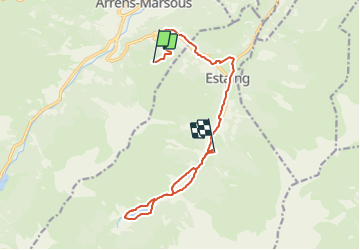
Trail Walking of 16.5 km to be discovered at Occitania, Hautespyrenees, Arrens-Marsous. This trail is proposed by piem.

Description

Tour du Val d'Azun en 6 jours avec des enfants à partir de 7 ans. Etape au refuge "les Viellettes"

Elevation profile

Positioning

Country:
France
Region :
Occitania
Department/Province :
Hautespyrenees
Municipality :
Arrens-Marsous
Location:
Unknown
Start:(UTM)
728138 ; 4758417 (30T) N.

Trails nearby

Trail Walking Arcizans-Dessus - la fontaine de Nabias - Photo
Walking
bernardbelmas

Walking

Very easy
(1)
Arcizans-Dessus, Occitania, Hautespyrenees, France
4.2 km | 6.8 km-effort
1h 40min
Yes
Trail Walking Estaing - Les Viellettes - Estaing - Photo
Walking
tracegps

Walking

Difficult
(1)
Estaing, Occitania, Hautespyrenees, France
13.1 km | 24 km-effort
4h 0min
Yes
Trail Walking Estaing - ESTAING  RS le der de 2022 - Photo
Walking
GUIDE
marmotte65

Walking

Easy
Estaing, Occitania, Hautespyrenees, France
3.6 km | 5.1 km-effort
1h 5min
Yes
Trail Walking Gaillagos - GAILLAGOS / Couret / Couraduque en boucle reco G3 - Photo
Walking
GUIDE
marmotte65

Walking

Difficult
Gaillagos, Occitania, Hautespyrenees, France
8.4 km | 14.3 km-effort
2h 30min
Yes
Trail Walking Arrens-Marsous - ARRENS MARSOUS Le Turon des aulhes    2906361 - Photo
Walking
GUIDE
marmotte65

Walking

Medium
(1)
Arrens-Marsous, Occitania, Hautespyrenees, France
9.5 km | 16.4 km-effort
5h 55min
Yes
Trail Walking Arrens-Marsous - col de soulor, lac de soum, col de bazes, col de soulor  - Photo
Walking
fbienmuller

Walking

Medium
Arrens-Marsous, Occitania, Hautespyrenees, France
16.4 km | 23 km-effort
5h 20min
Yes
Trail Walking Gaillagos - GAILLAGOS Col de Couret Couraduque en boucle G3 du 21/04/2023
Walking
GUIDE
marmotte65

Walking

Difficult
Gaillagos, Occitania, Hautespyrenees, France
8.2 km | 14.2 km-effort
2h 46min
Yes
Trail Walking Estaing - ESTAING autour du lac - Photo
Walking
GUIDE
marmotte65

Walking

Easy
Estaing, Occitania, Hautespyrenees, France
3.7 km | 5.3 km-effort
1h 9min
Yes
Trail Walking Estaing - ESTAING et la cabane d'Ariousse
Walking
GUIDE
marmotte65

Walking

Difficult
Estaing, Occitania, Hautespyrenees, France
10.3 km | 14.8 km-effort
2h 49min
Yes


Close
My subscriptions