![](/images/other/stat-length.png)
![Trail Walking Agüimes - Guayadeque - Photo](https://media.geolcdn.com/t/1900/400/ext.pjpeg?maxdim=2&url=https%3A%2F%2Fstatic1.geolcdn.com%2Fsiteimages%2Fupload%2Ffiles%2F1553511878bg_sport_marche.png)
Guayadeque
thomas.lucot
User
![Length](/images/other/stat-length.png)
Length
6.1 km
![Max alt](https://static1.geolcdn.com/siteimages/upload/files/1508320355ic_sort_altitude_max_24dp.png)
Max alt
788 m
![Uphill gradient](https://static1.geolcdn.com/siteimages/upload/files/1508320355ic_sort_den_pos_24dp.png)
Uphill gradient
419 m
![Km-Effort](/images/other/stat-length.png)
Km-Effort
11 km
![Min alt](https://static1.geolcdn.com/siteimages/upload/files/1508320355ic_sort_altitude_min_24dp.png)
Min alt
376 m
![Downhill gradient](https://static1.geolcdn.com/siteimages/upload/files/1508320355ic_sort_den_neg_24dp.png)
Downhill gradient
212 m
![Boucle](https://static1.geolcdn.com/siteimages/upload/files/16400158638029165_repeat_loop_refresh_sync_direction_icon.png)
Boucle
No
Creation date :
2022-07-19 15:20:01.0
Updated on :
2022-07-19 19:20:52.274
![Walking](https://static1.geolcdn.com/sitytour/trail-icons/101.png)
2h25
Difficulty : Medium
![Scan this QR Code to open this trail in the SityTrail application](https://capi.geolives.com/qq0zvz2zws4bq2lad0pu/sitytour/trails/3322606/qr.png?size=200)
FREE GPS app for hiking
About
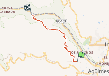
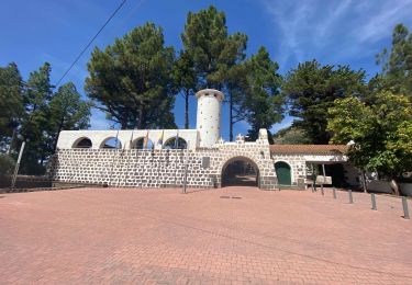
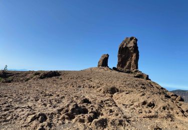
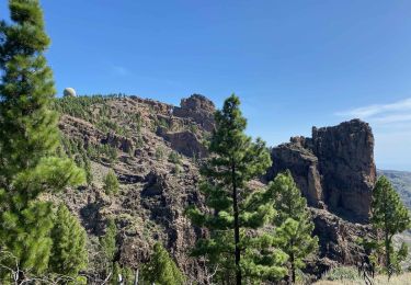
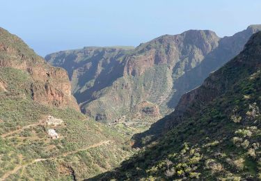
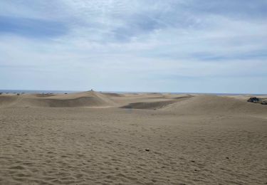
Trail Walking of 6.1 km to be discovered at Canary Islands, Las Palmas, Agüimes. This trail is proposed by thomas.lucot.
Description
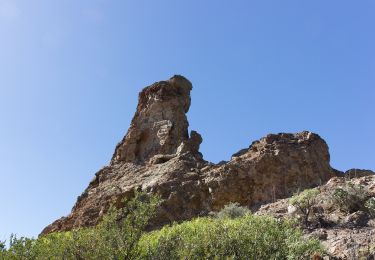
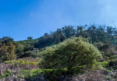
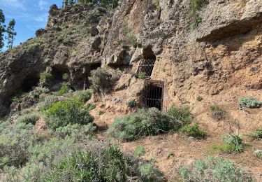
Une randonnée sympa à travers une végétation sèche qui se termine en haut du canyon de guayadeque. Il y a ensuite un chemin pour descendre le canyon. On arrive dans le village troglodyte ou un bar attend les touristes et randonneurs.
Positioning
Country:
Spain
Region :
Canary Islands
Department/Province :
Las Palmas
Municipality :
Agüimes
Location:
Unknown
Start:(Dec)
Start:(UTM)
455071 ; 3087291 (28R) N.
Comments
Trails nearby
![Trail On foot San Bartolomé de Tirajana - SLCC Chira - Cruz Grande - Photo](https://media.geolcdn.com/t/375/260/3067de9c-a0e0-4d99-ac43-40c01f10e3cd.jpeg&format=jpg&maxdim=2)
![On foot On foot](https://static1.geolcdn.com/sitytour/trail-icons/100.png)
SLCC Chira - Cruz Grande
On foot
Easy
San Bartolomé de Tirajana,
Canary Islands,
Las Palmas,
Spain
![](/images/other/stat-length.png)
6 km | 9.3 km-effort
2h 6min
![](https://static1.geolcdn.com/siteimages/upload/files/16400158638029165_repeat_loop_refresh_sync_direction_icon.png)
No
![Trail On foot Santa Brígida - Camino Pál Pino de Santa Brígida a Teror - Photo](https://media.geolcdn.com/t/375/260/6a78948a-9ccc-436d-9e9f-f497b172c722.jpeg&format=jpg&maxdim=2)
![On foot On foot](https://static1.geolcdn.com/sitytour/trail-icons/100.png)
Camino Pál Pino de Santa Brígida a Teror
On foot
Easy
Santa Brígida,
Canary Islands,
Las Palmas,
Spain
![](/images/other/stat-length.png)
3.3 km | 5.5 km-effort
1h 14min
![](https://static1.geolcdn.com/siteimages/upload/files/16400158638029165_repeat_loop_refresh_sync_direction_icon.png)
No
![Trail Walking San Bartolomé de Tirajana - Gran Canaria-San Bartolome 04-05-2017 - Photo](https://media.geolcdn.com/t/375/260/ext.jpg?maxdim=2&url=https%3A%2F%2Fstatic1.geolcdn.com%2Fsiteimages%2Fupload%2Ffiles%2F1553511878bg_sport_marche.png)
![Walking Walking](https://static1.geolcdn.com/sitytour/trail-icons/101.png)
Gran Canaria-San Bartolome 04-05-2017
Walking
Easy
(1)
San Bartolomé de Tirajana,
Canary Islands,
Las Palmas,
Spain
![](/images/other/stat-length.png)
9.4 km | 15.4 km-effort
3h 6min
![](https://static1.geolcdn.com/siteimages/upload/files/16400158638029165_repeat_loop_refresh_sync_direction_icon.png)
Yes
![Trail Walking Tejeda - Cuevas del Caballero (Gran Canaria) - Photo](https://media.geolcdn.com/t/375/260/3ff94903-10b1-42fb-8d94-63959785b52c.jpeg&format=jpg&maxdim=2)
![Walking Walking](https://static1.geolcdn.com/sitytour/trail-icons/101.png)
Cuevas del Caballero (Gran Canaria)
Walking
Medium
Tejeda,
Canary Islands,
Las Palmas,
Spain
![](/images/other/stat-length.png)
7.2 km | 12.3 km-effort
2h 5min
![](https://static1.geolcdn.com/siteimages/upload/files/16400158638029165_repeat_loop_refresh_sync_direction_icon.png)
Yes
![Trail Walking Tejeda - Barranco de la Mina (Gran Canaria) - Photo](https://media.geolcdn.com/t/375/260/afdf1e06-906e-4d56-8cbf-7bd8a33528d7.jpeg&format=jpg&maxdim=2)
![Walking Walking](https://static1.geolcdn.com/sitytour/trail-icons/101.png)
Barranco de la Mina (Gran Canaria)
Walking
Difficult
Tejeda,
Canary Islands,
Las Palmas,
Spain
![](/images/other/stat-length.png)
7 km | 12.8 km-effort
2h 37min
![](https://static1.geolcdn.com/siteimages/upload/files/16400158638029165_repeat_loop_refresh_sync_direction_icon.png)
Yes
![Trail Walking Tejeda - Roque Nublo (Gran Canaria) - Photo](https://media.geolcdn.com/t/375/260/1b9ffdcd-5b17-4fe3-8fab-f075c0d4fd91.jpeg&format=jpg&maxdim=2)
![Walking Walking](https://static1.geolcdn.com/sitytour/trail-icons/101.png)
Roque Nublo (Gran Canaria)
Walking
Medium
Tejeda,
Canary Islands,
Las Palmas,
Spain
![](/images/other/stat-length.png)
4.8 km | 7.7 km-effort
1h 36min
![](https://static1.geolcdn.com/siteimages/upload/files/16400158638029165_repeat_loop_refresh_sync_direction_icon.png)
Yes
![Trail Walking Tejeda - Pico de las Nieves (Gran Canaria) - Photo](https://media.geolcdn.com/t/375/260/8dd77f34-f9e0-4210-a8bf-aeffb88a20d1.jpeg&format=jpg&maxdim=2)
![Walking Walking](https://static1.geolcdn.com/sitytour/trail-icons/101.png)
Pico de las Nieves (Gran Canaria)
Walking
Medium
Tejeda,
Canary Islands,
Las Palmas,
Spain
![](/images/other/stat-length.png)
10.8 km | 18.2 km-effort
3h 32min
![](https://static1.geolcdn.com/siteimages/upload/files/16400158638029165_repeat_loop_refresh_sync_direction_icon.png)
Yes
![Trail Walking Ingenio - Barranco de Guayadeque (Gran Canaria) - Photo](https://media.geolcdn.com/t/375/260/0ae8eaae-9d0c-41c2-aaed-1d8d51004d0c.jpeg&format=jpg&maxdim=2)
![Walking Walking](https://static1.geolcdn.com/sitytour/trail-icons/101.png)
Barranco de Guayadeque (Gran Canaria)
Walking
Difficult
Ingenio,
Canary Islands,
Las Palmas,
Spain
![](/images/other/stat-length.png)
17.6 km | 29 km-effort
5h 23min
![](https://static1.geolcdn.com/siteimages/upload/files/16400158638029165_repeat_loop_refresh_sync_direction_icon.png)
Yes
![Trail Walking San Bartolomé de Tirajana - Les dunes de Maspalomas (Gran Canaria) - Photo](https://media.geolcdn.com/t/375/260/48960093-93ab-47a7-9967-fb29d928079d.jpeg&format=jpg&maxdim=2)
![Walking Walking](https://static1.geolcdn.com/sitytour/trail-icons/101.png)
Les dunes de Maspalomas (Gran Canaria)
Walking
Easy
(1)
San Bartolomé de Tirajana,
Canary Islands,
Las Palmas,
Spain
![](/images/other/stat-length.png)
9.3 km | 10.5 km-effort
2h 41min
![](https://static1.geolcdn.com/siteimages/upload/files/16400158638029165_repeat_loop_refresh_sync_direction_icon.png)
Yes