


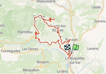


17 km | 30 km-effort


User


FREE GPS app for hiking
 SityTrail
IGN / Geographical institutes
SityTrail World
The world is yours!
Trail Road bike of 60 km to be discovered at Provence-Alpes-Côte d'Azur, Maritime Alps, Gilette. This trail is proposed by bosses21.
Colle Belle - 423 m /
Col de Rostan - 610 m /
Collet des Sausses - 626 m /
Col Saint-Michel - 935 m /
Mont Vial - 1549 m

Walking

Walking

On foot

On foot

Walking
Walking

Walking

Walking
Walking