![](/images/other/stat-length.png)
![Trail Walking Rochesson - ROCHESSON ... cascade de Battion. - Photo](https://media.geolcdn.com/t/1900/400/ext.pjpeg?maxdim=2&url=https%3A%2F%2Fmedia.geolcdn.com%2Ff%2F9a641ed8-d7eb-4db4-bc1a-dd0fcdfd739f.jpg)
ROCHESSON ... cascade de Battion.
GerardBouche
User
![Length](/images/other/stat-length.png)
Length
8.7 km
![Max alt](https://static1.geolcdn.com/siteimages/upload/files/1508320355ic_sort_altitude_max_24dp.png)
Max alt
675 m
![Uphill gradient](https://static1.geolcdn.com/siteimages/upload/files/1508320355ic_sort_den_pos_24dp.png)
Uphill gradient
314 m
![Km-Effort](/images/other/stat-length.png)
Km-Effort
12.9 km
![Min alt](https://static1.geolcdn.com/siteimages/upload/files/1508320355ic_sort_altitude_min_24dp.png)
Min alt
527 m
![Downhill gradient](https://static1.geolcdn.com/siteimages/upload/files/1508320355ic_sort_den_neg_24dp.png)
Downhill gradient
315 m
![Boucle](https://static1.geolcdn.com/siteimages/upload/files/16400158638029165_repeat_loop_refresh_sync_direction_icon.png)
Boucle
Yes
Creation date :
2022-07-14 06:41:07.08
Updated on :
2022-07-14 09:57:46.053
![Walking](https://static1.geolcdn.com/sitytour/trail-icons/101.png)
2h30
Difficulty : Medium
![Scan this QR Code to open this trail in the SityTrail application](https://capi.geolives.com/qq0zvz2zws4bq2lad0pu/sitytour/trails/3315759/qr.png?size=200)
FREE GPS app for hiking
About
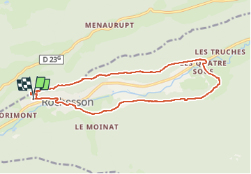
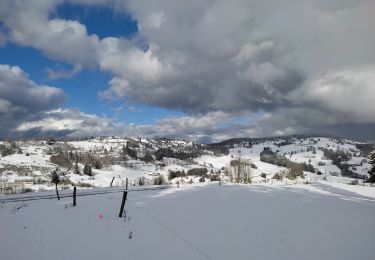
Trail Walking of 8.7 km to be discovered at Grand Est, Vosges, Rochesson. This trail is proposed by GerardBouche.
Description
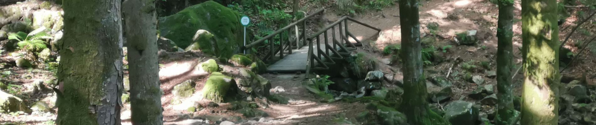
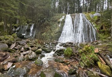
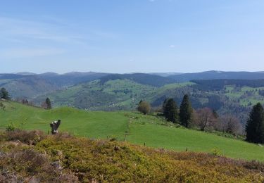
Superbe parcours par de petits sentiers boisés avec des éboulis par endroits. Par Roche des Ducs, les Quatre Sous, le quartier des Truches et la cascade de Battion.
.
Positioning
Country:
France
Region :
Grand Est
Department/Province :
Vosges
Municipality :
Rochesson
Location:
Unknown
Start:(Dec)
Start:(UTM)
334254 ; 5321243 (32U) N.
Comments
Trails nearby
![Trail Walking Sapois - La Cascade de la Pissoire - Photo](https://media.geolcdn.com/t/375/260/ext.jpg?maxdim=2&url=https%3A%2F%2Fservices.sitytrail.com%2FGeolivesWS%2FDownloadMedia.ashx%3FTrailID%3D110286%26Media%3D5680_3.jpg)
![Walking Walking](https://static1.geolcdn.com/sitytour/trail-icons/101.png)
La Cascade de la Pissoire
Walking
Medium
(2)
Sapois,
Grand Est,
Vosges,
France
![](/images/other/stat-length.png)
6.3 km | 8.9 km-effort
2h 0min
![](https://static1.geolcdn.com/siteimages/upload/files/16400158638029165_repeat_loop_refresh_sync_direction_icon.png)
Yes
![Trail Walking Sapois - La Cascade de la Pissoire - Photo](https://media.geolcdn.com/t/375/260/ext.jpg?maxdim=2&url=https%3A%2F%2Fstatic1.geolcdn.com%2Fsiteimages%2Fupload%2Ffiles%2F1553511878bg_sport_marche.png)
![Walking Walking](https://static1.geolcdn.com/sitytour/trail-icons/101.png)
La Cascade de la Pissoire
Walking
Easy
(3)
Sapois,
Grand Est,
Vosges,
France
![](/images/other/stat-length.png)
6.3 km | 8.9 km-effort
1h 40min
![](https://static1.geolcdn.com/siteimages/upload/files/16400158638029165_repeat_loop_refresh_sync_direction_icon.png)
Yes
![Trail Horseback riding Gerbamont - 2022-06-05 Rando CVA Gerbamont Dommartin les Remiremont - Photo](https://media.geolcdn.com/t/375/260/ext.jpg?maxdim=2&url=https%3A%2F%2Fmedia.geolcdn.com%2Ff%2Ffd6e9bbc-68c7-4aa5-ac35-74c2c082f858.jpg)
![Horseback riding Horseback riding](https://static1.geolcdn.com/sitytour/trail-icons/301.png)
2022-06-05 Rando CVA Gerbamont Dommartin les Remiremont
Horseback riding
Difficult
Gerbamont,
Grand Est,
Vosges,
France
![](/images/other/stat-length.png)
24 km | 34 km-effort
5h 10min
![](https://static1.geolcdn.com/siteimages/upload/files/16400158638029165_repeat_loop_refresh_sync_direction_icon.png)
No
![Trail Horseback riding Gerbamont - 2022-06-04 Rando CVA Gerbamont Boucle Foret de Noire Goutte - Photo](https://media.geolcdn.com/t/375/260/ext.jpg?maxdim=2&url=https%3A%2F%2Fmedia.geolcdn.com%2Ff%2F44bce39b-ceb9-4dae-b553-730e48ff9ece.jpg)
![Horseback riding Horseback riding](https://static1.geolcdn.com/sitytour/trail-icons/301.png)
2022-06-04 Rando CVA Gerbamont Boucle Foret de Noire Goutte
Horseback riding
Very difficult
Gerbamont,
Grand Est,
Vosges,
France
![](/images/other/stat-length.png)
31 km | 43 km-effort
6h 2min
![](https://static1.geolcdn.com/siteimages/upload/files/16400158638029165_repeat_loop_refresh_sync_direction_icon.png)
Yes
![Trail Walking Cornimont - Croix des Moinats - Photo](https://media.geolcdn.com/t/375/260/ext.jpg?maxdim=2&url=https%3A%2F%2Fmedia.geolcdn.com%2Ff%2Fca2e91a2-4aa7-4b64-a421-a0f91eabaf46.jpg)
![Walking Walking](https://static1.geolcdn.com/sitytour/trail-icons/101.png)
Croix des Moinats
Walking
Easy
Cornimont,
Grand Est,
Vosges,
France
![](/images/other/stat-length.png)
5.7 km | 7.6 km-effort
1h 15min
![](https://static1.geolcdn.com/siteimages/upload/files/16400158638029165_repeat_loop_refresh_sync_direction_icon.png)
Yes
![Trail Walking Saulxures-sur-Moselotte - circuit depuis col des Hayes - Photo](https://media.geolcdn.com/t/375/260/ext.jpg?maxdim=2&url=https%3A%2F%2Fmedia.geolcdn.com%2Ff%2Fcd39dddf-0c17-4c42-b853-306b20ab1bd1.jpg)
![Walking Walking](https://static1.geolcdn.com/sitytour/trail-icons/101.png)
circuit depuis col des Hayes
Walking
Medium
(1)
Saulxures-sur-Moselotte,
Grand Est,
Vosges,
France
![](/images/other/stat-length.png)
5.2 km | 7.3 km-effort
1h 41min
![](https://static1.geolcdn.com/siteimages/upload/files/16400158638029165_repeat_loop_refresh_sync_direction_icon.png)
Yes
![Trail Walking Basse-sur-le-Rupt - Col de menufosse-chalet des charmes-pierre 4 communes - Photo](https://media.geolcdn.com/t/375/260/ext.jpg?maxdim=2&url=https%3A%2F%2Fstatic1.geolcdn.com%2Fsiteimages%2Fupload%2Ffiles%2F1553511878bg_sport_marche.png)
![Walking Walking](https://static1.geolcdn.com/sitytour/trail-icons/101.png)
Col de menufosse-chalet des charmes-pierre 4 communes
Walking
Medium
(1)
Basse-sur-le-Rupt,
Grand Est,
Vosges,
France
![](/images/other/stat-length.png)
5 km | 6.6 km-effort
1h 29min
![](https://static1.geolcdn.com/siteimages/upload/files/16400158638029165_repeat_loop_refresh_sync_direction_icon.png)
Yes
![Trail Walking Gerbamont - cascadu bouchot vosges - Photo](https://media.geolcdn.com/t/375/260/ext.jpg?maxdim=2&url=https%3A%2F%2Fmedia.geolcdn.com%2Ff%2F16db8c38-6264-4f38-bfb6-26a747207489.jpg)
![Walking Walking](https://static1.geolcdn.com/sitytour/trail-icons/101.png)
cascadu bouchot vosges
Walking
Medium
(1)
Gerbamont,
Grand Est,
Vosges,
France
![](/images/other/stat-length.png)
7.9 km | 10.5 km-effort
2h 23min
![](https://static1.geolcdn.com/siteimages/upload/files/16400158638029165_repeat_loop_refresh_sync_direction_icon.png)
Yes
![Trail Walking Rochesson - Les Roches Saint-Jacques et la Cascade du Bouchot - Photo](https://media.geolcdn.com/t/375/260/ext.jpg?maxdim=2&url=https%3A%2F%2Fmedia.geolcdn.com%2Ff%2F23c5d313-a891-43e8-a564-2cb32555273c.jpg)
![Walking Walking](https://static1.geolcdn.com/sitytour/trail-icons/101.png)
Les Roches Saint-Jacques et la Cascade du Bouchot
Walking
Difficult
Rochesson,
Grand Est,
Vosges,
France
![](/images/other/stat-length.png)
15.6 km | 24 km-effort
6h 29min
![](https://static1.geolcdn.com/siteimages/upload/files/16400158638029165_repeat_loop_refresh_sync_direction_icon.png)
Yes