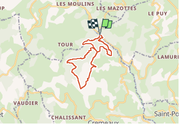
![](/images/other/stat-length.png)
![Trail Walking Saint-Jean-Saint-Maurice-sur-Loire - Cremeaux : zone forestière - Photo](https://media.geolcdn.com/t/1900/400/ext.pjpeg?maxdim=2&url=https%3A%2F%2Fmedia.geolcdn.com%2Ff%2F34dfc680-1788-4db0-adf2-b154d44ca9c0.jpg)
Cremeaux : zone forestière
Jgar
User
![Length](/images/other/stat-length.png)
![Max alt](https://static1.geolcdn.com/siteimages/upload/files/1508320355ic_sort_altitude_max_24dp.png)
![Uphill gradient](https://static1.geolcdn.com/siteimages/upload/files/1508320355ic_sort_den_pos_24dp.png)
![Km-Effort](/images/other/stat-length.png)
![Min alt](https://static1.geolcdn.com/siteimages/upload/files/1508320355ic_sort_altitude_min_24dp.png)
![Downhill gradient](https://static1.geolcdn.com/siteimages/upload/files/1508320355ic_sort_den_neg_24dp.png)
![Boucle](https://static1.geolcdn.com/siteimages/upload/files/16400158638029165_repeat_loop_refresh_sync_direction_icon.png)
![Walking](https://static1.geolcdn.com/sitytour/trail-icons/101.png)
6h12
Difficulty : Difficult
![Scan this QR Code to open this trail in the SityTrail application](https://capi.geolives.com/qq0zvz2zws4bq2lad0pu/sitytour/trails/3314987/qr.png?size=200)
FREE GPS app for hiking
About
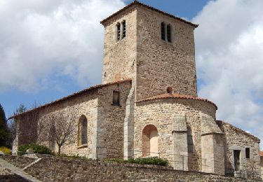
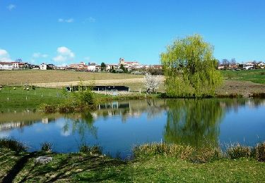
Trail Walking of 12.7 km to be discovered at Auvergne-Rhône-Alpes, Loire, Saint-Jean-Saint-Maurice-sur-Loire. This trail is proposed by Jgar.
Description
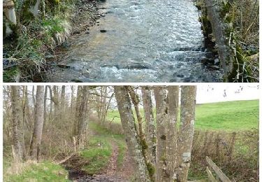
Parking lat 45,9501 et long 3,9264. Descendre la D 41 sur 400 m, prendre à droite le sentier qui traverse l'Isable et monter dans le bois Combemartin. A la cote 685, monter à droite.
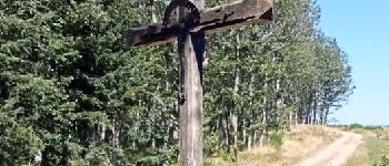
A la croix des Châtres, rejoindre ledit lieu et à la cote 750, tourner à droite sur le chemin balisé 18bis. Tourner 2 fois à gauche puis à droite après la grange en direction de Duivon. Après environ 500 m, ne poursuivez pas sur ce hameau mais
montez à droite en bordure du pré. Vous rejoindrez un chemin qui conduit au bois Duivon ou forêt de Cremeaux.
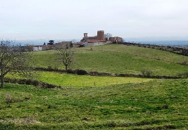
Poursuivre la rando jusqu'à la croix de Maillant (cote 838). Descendre au nord-est en admirant le panorama à 180°.
A la cote 800, tourner à droite et, devant le panneau "Chasse Bois Duivon", descendre en face dans la chênaie-hêtraie. Passer devant le panneau "Acca de Crémeaux" et à l'intersection, remonter le chemin de droite qui devient un peu embroussaillé avant la croix des Châtres.
Revenir quelques mètres en arrière et descendre à droite, à travers le bois Combemartin, jusqu'à la goutte Michonnet qui vous permettra, à droite, de retrouver le parking
Positioning
Comments
Trails nearby
![Trail sport Saint-Jean-Saint-Maurice-sur-Loire - Retour bis - Photo](https://media.geolcdn.com/t/375/260/ext.jpg?maxdim=2&url=https%3A%2F%2Fsecurestorage.geolives.com%2Fsitytour%2Ftrail-bg%2Fdefault.jpg)
sport
![](/images/other/stat-length.png)
![](https://static1.geolcdn.com/siteimages/upload/files/16400158638029165_repeat_loop_refresh_sync_direction_icon.png)
![Trail Walking Cherier - rocher de rochefort depuis la croix Trévingt - Photo](https://media.geolcdn.com/t/375/260/ext.jpg?maxdim=2&url=https%3A%2F%2Fmedia.geolcdn.com%2Ff%2Fdcc1659c-efdc-4c94-9e85-a848a823e0bd.jpg)
![Walking Walking](https://static1.geolcdn.com/sitytour/trail-icons/101.png)
Walking
![](/images/other/stat-length.png)
![](https://static1.geolcdn.com/siteimages/upload/files/16400158638029165_repeat_loop_refresh_sync_direction_icon.png)
![Trail Walking - Randonnée sur les plateaux au dessus du village de Moulins -Chérier - Photo](https://media.geolcdn.com/t/375/260/ext.jpg?maxdim=2&url=https%3A%2F%2Fmedia.geolcdn.com%2Ff%2F328a50ea-b5e1-4410-88c7-07bd0b3b435c.jpg)
![Walking Walking](https://static1.geolcdn.com/sitytour/trail-icons/101.png)
Walking
![](/images/other/stat-length.png)
![](https://static1.geolcdn.com/siteimages/upload/files/16400158638029165_repeat_loop_refresh_sync_direction_icon.png)
![Trail Walking Saint-Polgues - St Porgues - Photo](https://media.geolcdn.com/t/375/260/ext.jpg?maxdim=2&url=https%3A%2F%2Fmedia.geolcdn.com%2Ff%2F2c0dbc29-647a-418e-b0e9-5a7ae5d83d39.jpg)
![Walking Walking](https://static1.geolcdn.com/sitytour/trail-icons/101.png)
Walking
![](/images/other/stat-length.png)
![](https://static1.geolcdn.com/siteimages/upload/files/16400158638029165_repeat_loop_refresh_sync_direction_icon.png)
![Trail Walking Cherier - rando à Moulin Charier - Photo](https://media.geolcdn.com/t/375/260/ext.jpg?maxdim=2&url=https%3A%2F%2Fmedia.geolcdn.com%2Ff%2F3886ddf7-94b0-4692-af5c-3d0753f12223.jpg)
![Walking Walking](https://static1.geolcdn.com/sitytour/trail-icons/101.png)
Walking
![](/images/other/stat-length.png)
![](https://static1.geolcdn.com/siteimages/upload/files/16400158638029165_repeat_loop_refresh_sync_direction_icon.png)
![Trail Walking Villemontais - Villemontais : Chérier et Haut Ste-Agathe - Photo](https://media.geolcdn.com/t/375/260/ext.jpg?maxdim=2&url=https%3A%2F%2Fmedia.geolcdn.com%2Ff%2F43288f42-5353-465e-b07f-32492fc85c11.jpg)
![Walking Walking](https://static1.geolcdn.com/sitytour/trail-icons/101.png)
Walking
![](/images/other/stat-length.png)
![](https://static1.geolcdn.com/siteimages/upload/files/16400158638029165_repeat_loop_refresh_sync_direction_icon.png)
![Trail On foot Cherier - Les Moulins Chérier - boucles autour du vieux bourg - Photo](https://media.geolcdn.com/t/375/260/ext.jpg?maxdim=2&url=https%3A%2F%2Fmedia.geolcdn.com%2Ff%2F02a5a11d-56eb-4a94-af63-ae9a9466184f.jpg)
![On foot On foot](https://static1.geolcdn.com/sitytour/trail-icons/100.png)
On foot
![](/images/other/stat-length.png)
![](https://static1.geolcdn.com/siteimages/upload/files/16400158638029165_repeat_loop_refresh_sync_direction_icon.png)
![Trail Mountain bike Cremeaux - La boucle des croix - Crémeaux - Photo](https://media.geolcdn.com/t/375/260/ext.jpg?maxdim=2&url=https%3A%2F%2Fservices.sitytrail.com%2FGeolivesWS%2FDownloadMedia.ashx%3FTrailID%3D317774%26Media%3D17089_6.jpg)
![Mountain bike Mountain bike](https://static1.geolcdn.com/sitytour/trail-icons/202.png)
Mountain bike
![](/images/other/stat-length.png)
![](https://static1.geolcdn.com/siteimages/upload/files/16400158638029165_repeat_loop_refresh_sync_direction_icon.png)
![Trail Mountain bike Saint-Polgues - Vallée de l'Isable et exploitations agricoles - Saint-Polgues - Photo](https://media.geolcdn.com/t/375/260/ext.jpg?maxdim=2&url=https%3A%2F%2Fservices.sitytrail.com%2FGeolivesWS%2FDownloadMedia.ashx%3FTrailID%3D317773%26Media%3D17088_3.jpg)
![Mountain bike Mountain bike](https://static1.geolcdn.com/sitytour/trail-icons/202.png)
Mountain bike
![](/images/other/stat-length.png)
![](https://static1.geolcdn.com/siteimages/upload/files/16400158638029165_repeat_loop_refresh_sync_direction_icon.png)