Trail Walking Névache - Lac de Laramon, lac Serpent, Lacs des Gardioles - Photo

Lac de Laramon, lac Serpent, Lacs des Gardioles

© OpenStreetMap contributors
Length
Length
6.6 km
Max alt
Max alt
2689 m
Uphill gradient
Uphill gradient
822 m
Km-Effort
Km-Effort  
15 km
Min alt
Min alt
1861 m
Downhill gradient
Downhill gradient
65 m
Boucle
Boucle
No
Creation date :
2022-07-13 05:02:01.425
Updated on :
2022-10-25 16:10:02.001

(0 Reviews)

Walking
Walking
4h42
Difficulty : Difficult

Scan this QR Code to open this trail in the SityTrail application

FREE GPS app for hiking

Logo SityTrail SityTrail

IGN / Geographical institutes

Download SityTrail from the App Store Download SityTrail from Google Play

Logo SityTrail SityTrail World

The world is yours!

Download SityTrail from the App Store Download SityTrail from Google Play Download SityTrail on Huawei AppGallery

About

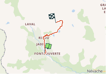
Trail Walking of 6.6 km to be discovered at Provence-Alpes-Côte d'Azur, Hautes-Alpes, Névache. This trail is proposed by Hugues Michel.

Description

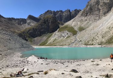
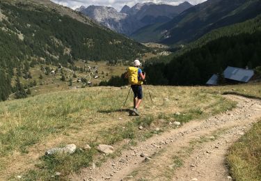
Au départ du parking de Foncouverte un dénivelé d’un peu plus de 800m nous permet de découvrir successivement les lacs de Laramon, lac Serpent, puis les lacs des Gardioles. Les tracés habituels s’arrêtent au second, mais plus on monte meilleure est la vue sur le Pelvoux, la Barre des Ecrins, le pic de la Meije… Somptueux ! Pas de difficulté.
L’application mobile de suivi classe cette randonnée en difficile en raison du temps de marche et des 800m de dénivelé (13,2 km aller retour).

Elevation profile

Photos

Positioning

Country:
France
Region :
Provence-Alpes-Côte d'Azur
Department/Province :
Hautes-Alpes
Municipality :
Névache
Location:
Unknown
Start:(UTM)
306647 ; 4989662 (32T) N.

Trails nearby

Trail Walking Névache - Briançonnais Lac du Serpent - Photo
Walking
GUIDE
Orcal37

Walking

Medium
(2)
Névache, Provence-Alpes-Côte d'Azur, Hautes-Alpes, France
10 km | 18 km-effort
3h 10min
Yes
Trail Walking Névache - Col du Chardonnet - Névache - Photo
Walking
tracegps

Walking

Medium
(3)
Névache, Provence-Alpes-Côte d'Azur, Hautes-Alpes, France
12.3 km | 23 km-effort
4h 0min
Yes
Trail Walking Névache - Via Alpina - R127: Névache > Le Monêtier-les-Bains - Photo
Walking
tracegps

Walking

Difficult
(1)
Névache, Provence-Alpes-Côte d'Azur, Hautes-Alpes, France
15.5 km | 28 km-effort
5h 0min
No
Trail Walking Névache - Beraudes  - Photo
Walking
GUIDE
jouans

Walking

Medium
Névache, Provence-Alpes-Côte d'Azur, Hautes-Alpes, France
11.1 km | 22 km-effort
6h 33min
No
Trail Walking Névache - Col roche noire  - Photo
Walking
GUIDE
jouans

Walking

Difficult
Névache, Provence-Alpes-Côte d'Azur, Hautes-Alpes, France
17.1 km | 31 km-effort
6h 37min
Yes
Trail Walking Névache - la roche du Chardonnet - Photo
Walking
GUIDE
amiral13

Walking

Medium
Névache, Provence-Alpes-Côte d'Azur, Hautes-Alpes, France
16.6 km | 29 km-effort
7h 26min
Yes
Trail Walking Névache - Lacs Laramon et Serpent - Photo
Walking
neoroll44

Walking

Medium
(2)
Névache, Provence-Alpes-Côte d'Azur, Hautes-Alpes, France
10.4 km | 21 km-effort
6h 0min
Yes
Trail Other activity Névache - Pointe des Cerces . Circuit du lac rouge - Photo
Other activity
GUIDE
nadd73

Other activity

Difficult
Névache, Provence-Alpes-Côte d'Azur, Hautes-Alpes, France
13.5 km | 32 km-effort
7h 53min
Yes
Trail Walking Névache - lacs laramon, du serpent, des gardioles et pic du lac blanc - Photo
Walking
GUIDE
amiral13

Walking

Medium
(1)
Névache, Provence-Alpes-Côte d'Azur, Hautes-Alpes, France
15.8 km | 31 km-effort
7h 30min
Yes


Close
My subscriptions