Trail Walking Lescun - Rando lac d'Ansabère - Photo
 Fab-Oz
Fab-Oz

User

© OpenStreetMap contributors
Length
Length
15 km
Max alt
Max alt
1895 m
Uphill gradient
Uphill gradient
985 m
Km-Effort
Km-Effort  
28 km
Min alt
Min alt
959 m
Downhill gradient
Downhill gradient
985 m
Boucle
Boucle
Yes
Creation date :
2022-07-12 10:06:32.213
Updated on :
2022-07-12 14:10:10.683

(0 Reviews)

Walking
Walking
3h48
Difficulty : Difficult

Scan this QR Code to open this trail in the SityTrail application

FREE GPS app for hiking

Logo SityTrail SityTrail

IGN / Geographical institutes

Download SityTrail from the App Store Download SityTrail from Google Play

Logo SityTrail SityTrail World

The world is yours!

Download SityTrail from the App Store Download SityTrail from Google Play Download SityTrail on Huawei AppGallery

About

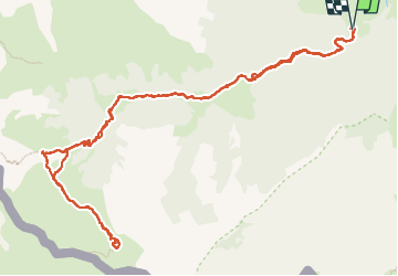
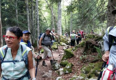
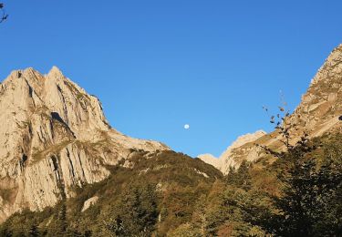
Trail Walking of 15 km to be discovered at New Aquitaine, Pyrénées-Atlantiques, Lescun. This trail is proposed by Fab-Oz.

Description

Aller retour jusqu'au lac d'Ansabère au départ de Masousa, 15km.
La montée est régulière, avec une bonne partie ombragée dans la forêt de Lescun, jusqu'au cabanes d'Ansabère. La fin jusqu'au lac est un peu plus difficile, en plein soleil.
Variante : possibilité de partir du pont de Lamary en empruntant le chemin en pierres pour gagner presque 2km (soit 4km A/R)

Elevation profile

Positioning

Country:
France
Region :
New Aquitaine
Department/Province :
Pyrénées-Atlantiques
Municipality :
Lescun
Location:
Unknown
Start:(UTM)
690044 ; 4753706 (30T) N.

Trails nearby

Trail Walking Lescun - Le plateau de Sanchèse - Lescun - Photo
Walking
tracegps

Walking

Easy
(2)
Lescun, New Aquitaine, Pyrénées-Atlantiques, France
5.4 km | 7.4 km-effort
2h 0min
Yes
Trail Walking Lescun - Lac de Lhurs - Photo
Walking
tracegps

Walking

Medium
(2)
Lescun, New Aquitaine, Pyrénées-Atlantiques, France
9.5 km | 19.2 km-effort
4h 0min
Yes
Trail On foot Lescun - Cabanes et Lac de Lhurs asp51 - Photo
On foot
GUIDE+

On foot

Easy
Lescun, New Aquitaine, Pyrénées-Atlantiques, France
5.9 km | 13.2 km-effort
2h 59min
No
Trail On foot Lescun - Tour du Belvédère asp47 - Photo
On foot
GUIDE+

On foot

Easy
Lescun, New Aquitaine, Pyrénées-Atlantiques, France
4.4 km | 8.9 km-effort
2h 1min
Yes
Trail On foot Lescun - Refuge de Linza par le Col de Pétragème asp119 - Photo
On foot
GUIDE+

On foot

Medium
Lescun, New Aquitaine, Pyrénées-Atlantiques, France
13.1 km | 27 km-effort
6h 14min
No
Trail Walking Lescun - Cirque de Lescun - Photo
Walking
HaschKnight

Walking

Medium
(1)
Lescun, New Aquitaine, Pyrénées-Atlantiques, France
5.5 km | 7.8 km-effort
1h 46min
Yes
Trail Walking Lescun - LESCUN Laberouat pas d azun LPC G3/G4
Walking
GUIDE
marmotte65

Walking

Difficult
Lescun, New Aquitaine, Pyrénées-Atlantiques, France
9.4 km | 15.5 km-effort
3h 15min
Yes
Trail Walking Lescun - Lac d'Ansabère suivi du lac d'Achérito - Photo
Walking
bedous

Walking

Difficult
Lescun, New Aquitaine, Pyrénées-Atlantiques, France
12.3 km | 25 km-effort
5h 35min
Yes
Trail Walking Lescun - Lac et cabane de Lurhs - Photo
Walking
bedous

Walking

Medium
Lescun, New Aquitaine, Pyrénées-Atlantiques, France
9.3 km | 17.7 km-effort
4h 1min
Yes


Close
My subscriptions