![](/images/other/stat-length.png)
![Trail Walking Saint-Véran - Col de Chamoussière - Photo](https://media.geolcdn.com/t/1900/400/ext.pjpeg?maxdim=2&url=https%3A%2F%2Fstatic1.geolcdn.com%2Fsiteimages%2Fupload%2Ffiles%2F1553511878bg_sport_marche.png)
Col de Chamoussière
stelh
User
![Length](/images/other/stat-length.png)
Length
11 km
![Max alt](https://static1.geolcdn.com/siteimages/upload/files/1508320355ic_sort_altitude_max_24dp.png)
Max alt
2880 m
![Uphill gradient](https://static1.geolcdn.com/siteimages/upload/files/1508320355ic_sort_den_pos_24dp.png)
Uphill gradient
592 m
![Km-Effort](/images/other/stat-length.png)
Km-Effort
18.8 km
![Min alt](https://static1.geolcdn.com/siteimages/upload/files/1508320355ic_sort_altitude_min_24dp.png)
Min alt
2296 m
![Downhill gradient](https://static1.geolcdn.com/siteimages/upload/files/1508320355ic_sort_den_neg_24dp.png)
Downhill gradient
585 m
![Boucle](https://static1.geolcdn.com/siteimages/upload/files/16400158638029165_repeat_loop_refresh_sync_direction_icon.png)
Boucle
Yes
Creation date :
2014-12-10 00:00:00.0
Updated on :
2014-12-10 00:00:00.0
![Walking](https://static1.geolcdn.com/sitytour/trail-icons/101.png)
5h06
Difficulty : Medium
![Scan this QR Code to open this trail in the SityTrail application](https://capi.geolives.com/qq0zvz2zws4bq2lad0pu/sitytour/trails/330959/qr.png?size=200)
FREE GPS app for hiking
About
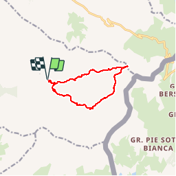
Trail Walking of 11 km to be discovered at Provence-Alpes-Côte d'Azur, Hautes-Alpes, Saint-Véran. This trail is proposed by stelh.
Description
Rando en boucle à partir de la chapelle de Clausis. Montée assez régulière dans un alpage très majestueux, avec quelques raidillons. Au col, vue superbe sur le Viso. Descente par le refuge de la Blanche, puis dans le vallon de la Mourière.
Positioning
Country:
France
Region :
Provence-Alpes-Côte d'Azur
Department/Province :
Hautes-Alpes
Municipality :
Saint-Véran
Location:
Unknown
Start:(Dec)
Start:(UTM)
335062 ; 4949159 (32T) N.
Comments
Trails nearby
![Trail Walking Saint-Véran - Lac de la Blanche, lacs blanchet et pic de Caramantran - Photo](https://media.geolcdn.com/t/375/260/ext.jpg?maxdim=2&url=https%3A%2F%2Fservices.sitytrail.com%2FGeolivesWS%2FDownloadMedia.ashx%3FTrailID%3D596077%26Media%3Dfix__20160710142025.jpg)
![Walking Walking](https://static1.geolcdn.com/sitytour/trail-icons/101.png)
Lac de la Blanche, lacs blanchet et pic de Caramantran
Walking
Medium
(2)
Saint-Véran,
Provence-Alpes-Côte d'Azur,
Hautes-Alpes,
France
![](/images/other/stat-length.png)
13.1 km | 23 km-effort
6h 12min
![](https://static1.geolcdn.com/siteimages/upload/files/16400158638029165_repeat_loop_refresh_sync_direction_icon.png)
Yes
![Trail Walking Saint-Véran - Pic de Château Renard 2989 m - Photo](https://media.geolcdn.com/t/375/260/b1e39ce8-7b43-487a-9c60-c67e480e0f64.jpg&format=jpg&maxdim=2)
![Walking Walking](https://static1.geolcdn.com/sitytour/trail-icons/101.png)
Pic de Château Renard 2989 m
Walking
Medium
(1)
Saint-Véran,
Provence-Alpes-Côte d'Azur,
Hautes-Alpes,
France
![](/images/other/stat-length.png)
6.9 km | 16.1 km-effort
2h 43min
![](https://static1.geolcdn.com/siteimages/upload/files/16400158638029165_repeat_loop_refresh_sync_direction_icon.png)
No
![Trail Walking Saint-Véran - boucle St Veran - Refuge de la blanche - Photo](https://media.geolcdn.com/t/375/260/ext.jpg?maxdim=2&url=https%3A%2F%2Fservices.sitytrail.com%2FGeolivesWS%2FDownloadMedia.ashx%3FTrailID%3D458178%26Media%3Dfix__20150812092118.jpg)
![Walking Walking](https://static1.geolcdn.com/sitytour/trail-icons/101.png)
boucle St Veran - Refuge de la blanche
Walking
Medium
(1)
Saint-Véran,
Provence-Alpes-Côte d'Azur,
Hautes-Alpes,
France
![](/images/other/stat-length.png)
19.3 km | 28 km-effort
5h 15min
![](https://static1.geolcdn.com/siteimages/upload/files/16400158638029165_repeat_loop_refresh_sync_direction_icon.png)
Yes
![Trail Snowshoes Saint-Véran - Saint Véran - Col de Chamoussière - Pic de Caramantran - Refuge de la Blanche - Photo](https://media.geolcdn.com/t/375/260/06173460-f42b-478a-96a7-0b988a782a3f.jpg&format=jpg&maxdim=2)
![Snowshoes Snowshoes](https://static1.geolcdn.com/sitytour/trail-icons/504.png)
Saint Véran - Col de Chamoussière - Pic de Caramantran - Refuge de la Blanche
Snowshoes
Difficult
Saint-Véran,
Provence-Alpes-Côte d'Azur,
Hautes-Alpes,
France
![](/images/other/stat-length.png)
22 km | 38 km-effort
5h 30min
![](https://static1.geolcdn.com/siteimages/upload/files/16400158638029165_repeat_loop_refresh_sync_direction_icon.png)
Yes
![Trail Snowshoes Molines-en-Queyras - Pont de Lariane - Col de Longet - Observatoire et Pic de Château Renard - Photo](https://media.geolcdn.com/t/375/260/2e616693-709e-46d9-b0ec-3e673e22ccda.jpg&format=jpg&maxdim=2)
![Snowshoes Snowshoes](https://static1.geolcdn.com/sitytour/trail-icons/504.png)
Pont de Lariane - Col de Longet - Observatoire et Pic de Château Renard
Snowshoes
Medium
Molines-en-Queyras,
Provence-Alpes-Côte d'Azur,
Hautes-Alpes,
France
![](/images/other/stat-length.png)
16.1 km | 30 km-effort
5h 0min
![](https://static1.geolcdn.com/siteimages/upload/files/16400158638029165_repeat_loop_refresh_sync_direction_icon.png)
Yes
![Trail Walking Molines-en-Queyras - le tour du Pain de Sucre - Photo](https://media.geolcdn.com/t/375/260/ext.jpg?maxdim=2&url=https%3A%2F%2Fservices.sitytrail.com%2FGeolivesWS%2FDownloadMedia.ashx%3FTrailID%3D820382%26Media%3Dfix__20170830144825.jpg)
![Walking Walking](https://static1.geolcdn.com/sitytour/trail-icons/101.png)
le tour du Pain de Sucre
Walking
Difficult
Molines-en-Queyras,
Provence-Alpes-Côte d'Azur,
Hautes-Alpes,
France
![](/images/other/stat-length.png)
8.1 km | 16 km-effort
4h 57min
![](https://static1.geolcdn.com/siteimages/upload/files/16400158638029165_repeat_loop_refresh_sync_direction_icon.png)
Yes
![Trail Walking Saint-Véran - Pic de Caramantran - Photo](https://media.geolcdn.com/t/375/260/ext.jpg?maxdim=2&url=https%3A%2F%2Fservices.sitytrail.com%2FGeolivesWS%2FDownloadMedia.ashx%3FTrailID%3D629317%26Media%3D93967439-727d-490c-bf0f-c5937248e7c8.jpg)
![Walking Walking](https://static1.geolcdn.com/sitytour/trail-icons/101.png)
Pic de Caramantran
Walking
Very difficult
Saint-Véran,
Provence-Alpes-Côte d'Azur,
Hautes-Alpes,
France
![](/images/other/stat-length.png)
12 km | 23 km-effort
4h 41min
![](https://static1.geolcdn.com/siteimages/upload/files/16400158638029165_repeat_loop_refresh_sync_direction_icon.png)
Yes
![Trail Walking Molines-en-Queyras - Lacs Foréant, Egorgéou, Baricle et de l'Eychassier - Photo](https://media.geolcdn.com/t/375/260/ext.jpg?maxdim=2&url=https%3A%2F%2Fservices.sitytrail.com%2FGeolivesWS%2FDownloadMedia.ashx%3FTrailID%3D597581%26Media%3Dfix__20160713160454.jpg)
![Walking Walking](https://static1.geolcdn.com/sitytour/trail-icons/101.png)
Lacs Foréant, Egorgéou, Baricle et de l'Eychassier
Walking
Medium
Molines-en-Queyras,
Provence-Alpes-Côte d'Azur,
Hautes-Alpes,
France
![](/images/other/stat-length.png)
13.8 km | 24 km-effort
6h 20min
![](https://static1.geolcdn.com/siteimages/upload/files/16400158638029165_repeat_loop_refresh_sync_direction_icon.png)
Yes
![Trail Walking Molines-en-Queyras - le pain de sucre - Photo](https://media.geolcdn.com/t/375/260/ext.jpg?maxdim=2&url=https%3A%2F%2Fservices.sitytrail.com%2FGeolivesWS%2FDownloadMedia.ashx%3FTrailID%3D444362%26Media%3Dfix__20150712140232.jpg)
![Walking Walking](https://static1.geolcdn.com/sitytour/trail-icons/101.png)
le pain de sucre
Walking
Difficult
(1)
Molines-en-Queyras,
Provence-Alpes-Côte d'Azur,
Hautes-Alpes,
France
![](/images/other/stat-length.png)
4.5 km | 10.1 km-effort
4h 39min
![](https://static1.geolcdn.com/siteimages/upload/files/16400158638029165_repeat_loop_refresh_sync_direction_icon.png)
Yes