![](/images/other/stat-length.png)
zarautz getaria
henribatut
User
![Length](/images/other/stat-length.png)
Length
14.4 km
![Max alt](https://static1.geolcdn.com/siteimages/upload/files/1508320355ic_sort_altitude_max_24dp.png)
Max alt
262 m
![Uphill gradient](https://static1.geolcdn.com/siteimages/upload/files/1508320355ic_sort_den_pos_24dp.png)
Uphill gradient
479 m
![Km-Effort](/images/other/stat-length.png)
Km-Effort
21 km
![Min alt](https://static1.geolcdn.com/siteimages/upload/files/1508320355ic_sort_altitude_min_24dp.png)
Min alt
11 m
![Downhill gradient](https://static1.geolcdn.com/siteimages/upload/files/1508320355ic_sort_den_neg_24dp.png)
Downhill gradient
478 m
![Boucle](https://static1.geolcdn.com/siteimages/upload/files/16400158638029165_repeat_loop_refresh_sync_direction_icon.png)
Boucle
Yes
Creation date :
2022-07-07 08:45:43.635
Updated on :
2022-07-07 17:46:46.449
![Walking](https://static1.geolcdn.com/sitytour/trail-icons/101.png)
4h00
Difficulty : Easy
![Scan this QR Code to open this trail in the SityTrail application](https://capi.geolives.com/qq0zvz2zws4bq2lad0pu/sitytour/trails/3308102/qr.png?size=200)
FREE GPS app for hiking
About
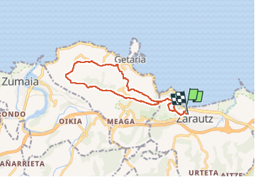
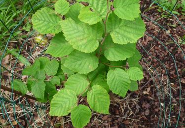
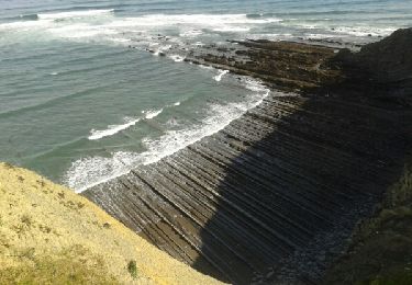
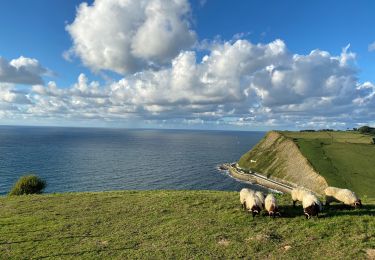
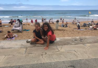
Trail Walking of 14.4 km to be discovered at Autonomous Community of the Basque Country, Gipuzkoa, Zarautz. This trail is proposed by henribatut.
Description
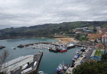
fait le 7 juillet 2022 rando très agréable en balcon sur l' ocean et Getaria. Sur bon Chemins 2 kms après Getaria sur petite route peux fréquentée. Possibilité à Getaria de revenir sur Zarautz par chemin le long de la route au dessus de la mer
Positioning
Country:
Spain
Region :
Autonomous Community of the Basque Country
Department/Province :
Gipuzkoa
Municipality :
Zarautz
Location:
Unknown
Start:(Dec)
Start:(UTM)
566794 ; 4792906 (30T) N.
Comments
Trails nearby
![Trail On foot Aia - SL-GI 4001 PAGOETA Agorregi: burnia eta ura - Photo](https://media.geolcdn.com/t/375/260/07f817b8-a8c4-417a-a39c-7c994ef7778f.jpeg&format=jpg&maxdim=2)
![On foot On foot](https://static1.geolcdn.com/sitytour/trail-icons/100.png)
SL-GI 4001 PAGOETA Agorregi: burnia eta ura
On foot
Easy
Aia,
Autonomous Community of the Basque Country,
Gipuzkoa,
Spain
![](/images/other/stat-length.png)
3.6 km | 5.4 km-effort
1h 14min
![](https://static1.geolcdn.com/siteimages/upload/files/16400158638029165_repeat_loop_refresh_sync_direction_icon.png)
Yes
![Trail Walking Zarautz - G4 getaria - Photo](https://media.geolcdn.com/t/375/260/48db115b-22eb-4104-8f5f-3ebc9e40ba1c.jpg&format=jpg&maxdim=2)
![Walking Walking](https://static1.geolcdn.com/sitytour/trail-icons/101.png)
G4 getaria
Walking
Medium
Zarautz,
Autonomous Community of the Basque Country,
Gipuzkoa,
Spain
![](/images/other/stat-length.png)
5.9 km | 7.7 km-effort
3h 0min
![](https://static1.geolcdn.com/siteimages/upload/files/16400158638029165_repeat_loop_refresh_sync_direction_icon.png)
No
![Trail On foot Aia - SL-GI 4002 PAGOETA Faunaren ibilbidea - Photo](https://media.geolcdn.com/t/375/260/75c8baa6-c83c-40ba-87d1-b9980fb1f332.jpeg&format=jpg&maxdim=2)
![On foot On foot](https://static1.geolcdn.com/sitytour/trail-icons/100.png)
SL-GI 4002 PAGOETA Faunaren ibilbidea
On foot
Easy
Aia,
Autonomous Community of the Basque Country,
Gipuzkoa,
Spain
![](/images/other/stat-length.png)
6.2 km | 9.4 km-effort
2h 8min
![](https://static1.geolcdn.com/siteimages/upload/files/16400158638029165_repeat_loop_refresh_sync_direction_icon.png)
Yes
![Trail Walking Zarautz - Txakoli - Photo](https://media.geolcdn.com/t/375/260/ext.jpg?maxdim=2&url=https%3A%2F%2Fservices.sitytrail.com%2FGeolivesWS%2FDownloadMedia.ashx%3FTrailID%3D646839%26Media%3D20161016110141.jpg)
![Walking Walking](https://static1.geolcdn.com/sitytour/trail-icons/101.png)
Txakoli
Walking
Easy
Zarautz,
Autonomous Community of the Basque Country,
Gipuzkoa,
Spain
![](/images/other/stat-length.png)
18 km | 27 km-effort
3h 6min
![](https://static1.geolcdn.com/siteimages/upload/files/16400158638029165_repeat_loop_refresh_sync_direction_icon.png)
Yes
![Trail Walking Getaria - JFT YB Étape 26 24-5-2014 - Photo](https://media.geolcdn.com/t/375/260/ext.jpg?maxdim=2&url=https%3A%2F%2Fservices.sitytrail.com%2FGeolivesWS%2FDownloadMedia.ashx%3FTrailID%3D304855%26Media%3Dfix__20140524104124.jpg)
![Walking Walking](https://static1.geolcdn.com/sitytour/trail-icons/101.png)
JFT YB Étape 26 24-5-2014
Walking
Easy
Getaria,
Autonomous Community of the Basque Country,
Gipuzkoa,
Spain
![](/images/other/stat-length.png)
18 km | 28 km-effort
5h 7min
![](https://static1.geolcdn.com/siteimages/upload/files/16400158638029165_repeat_loop_refresh_sync_direction_icon.png)
No
![Trail Walking Getaria - Zumaia - Photo](https://media.geolcdn.com/t/375/260/b8fda268-989f-4b28-a0e2-5b9b7a80af56.jpg&format=jpg&maxdim=2)
![Walking Walking](https://static1.geolcdn.com/sitytour/trail-icons/101.png)
Zumaia
Walking
Difficult
Getaria,
Autonomous Community of the Basque Country,
Gipuzkoa,
Spain
![](/images/other/stat-length.png)
8.7 km | 12.1 km-effort
2h 22min
![](https://static1.geolcdn.com/siteimages/upload/files/16400158638029165_repeat_loop_refresh_sync_direction_icon.png)
Yes
![Trail Walking Getaria - Getaria zaraost - Photo](https://media.geolcdn.com/t/375/260/adda4d22-c241-4bc8-8254-22dd46679f93.jpg&format=jpg&maxdim=2)
![Walking Walking](https://static1.geolcdn.com/sitytour/trail-icons/101.png)
Getaria zaraost
Walking
Getaria,
Autonomous Community of the Basque Country,
Gipuzkoa,
Spain
![](/images/other/stat-length.png)
11.4 km | 15 km-effort
6h 32min
![](https://static1.geolcdn.com/siteimages/upload/files/16400158638029165_repeat_loop_refresh_sync_direction_icon.png)
Yes
![Trail Walking Orio - Orio-Deba - Photo](https://media.geolcdn.com/t/375/260/ext.jpg?maxdim=2&url=https%3A%2F%2Fstatic1.geolcdn.com%2Fsiteimages%2Fupload%2Ffiles%2F1553511878bg_sport_marche.png)
![Walking Walking](https://static1.geolcdn.com/sitytour/trail-icons/101.png)
Orio-Deba
Walking
Difficult
Orio,
Autonomous Community of the Basque Country,
Gipuzkoa,
Spain
![](/images/other/stat-length.png)
30 km | 41 km-effort
8h 45min
![](https://static1.geolcdn.com/siteimages/upload/files/16400158638029165_repeat_loop_refresh_sync_direction_icon.png)
No
![Trail Walking Getaria - 003 Getaria - Ibiri - Photo](https://media.geolcdn.com/t/375/260/ext.jpg?maxdim=2&url=https%3A%2F%2Fstatic1.geolcdn.com%2Fsiteimages%2Fupload%2Ffiles%2F1553511878bg_sport_marche.png)
![Walking Walking](https://static1.geolcdn.com/sitytour/trail-icons/101.png)
003 Getaria - Ibiri
Walking
Very difficult
Getaria,
Autonomous Community of the Basque Country,
Gipuzkoa,
Spain
![](/images/other/stat-length.png)
19.2 km | 31 km-effort
6h 26min
![](https://static1.geolcdn.com/siteimages/upload/files/16400158638029165_repeat_loop_refresh_sync_direction_icon.png)
No