Trail Mountain bike Mazaugues - Montée Mourré d'Agnis - Photo
© OpenStreetMap contributors
Length
Length
14.8 km
Max alt
Max alt
866 m
Uphill gradient
Uphill gradient
518 m
Km-Effort
Km-Effort  
22 km
Min alt
Min alt
399 m
Downhill gradient
Downhill gradient
518 m
Boucle
Boucle
Yes
Creation date :
2014-12-10 00:00:00.0
Updated on :
2014-12-10 00:00:00.0

(1 Reviews)

Mountain bike
Mountain bike
2h44
Difficulty : Medium

Scan this QR Code to open this trail in the SityTrail application

FREE GPS app for hiking

Logo SityTrail SityTrail

IGN / Geographical institutes

Download SityTrail from the App Store Download SityTrail from Google Play

Logo SityTrail SityTrail World

The world is yours!

Download SityTrail from the App Store Download SityTrail from Google Play Download SityTrail on Huawei AppGallery

About

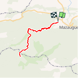
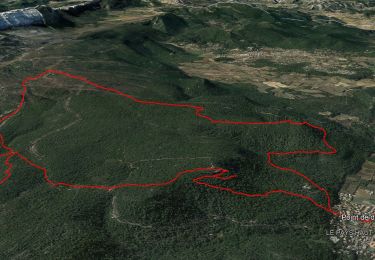
Trail Mountain bike of 14.8 km to be discovered at Provence-Alpes-Côte d'Azur, Var, Mazaugues. This trail is proposed by philippe.gayot.

Description

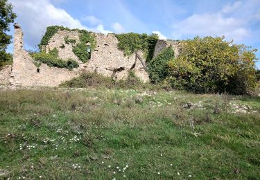
Montée Mourré d'Agnès depuis chemin St Victor.
Retour par le même chemin car ascension finale trop périlleuse

Elevation profile

Positioning

Country:
France
Region :
Provence-Alpes-Côte d'Azur
Department/Province :
Var
Municipality :
Mazaugues
Location:
Unknown
Start:(UTM)
735719 ; 4803986 (31T) N.

Comments

Please log in to post a review or rate the element


La fin de l'ascension du mourré d'Agnis s'est révélé trop périlleuse avec un VTT, donc retour par le même chemin


Trails nearby

Trail Walking Mazaugues - Mazaugues 21.4.24 - Photo
Walking
GUIDE
fredetpascale

Walking

Medium
(1)
Mazaugues, Provence-Alpes-Côte d'Azur, Var, France
11.1 km | 17.8 km-effort
4h 0min
Yes
Trail Walking Tourves - SityTrail - Tourves- Le Saut du Cabri - Les gorges du Caramy - Photo
Walking
GUIDE
affinetataille

Walking

Medium
(1)
Tourves, Provence-Alpes-Côte d'Azur, Var, France
12.6 km | 17.6 km-effort
6h 0min
Yes
Trail Walking Rougiers - SityTrail - Rougiers, Piégu, la fontaine de la Guillandière, le Castrum - Photo
Walking
GUIDE
affinetataille

Walking

Medium
(1)
Rougiers, Provence-Alpes-Côte d'Azur, Var, France
14.8 km | 22 km-effort
6h 0min
Yes
Trail Mountain bike Rougiers - Crêtes de la Sainte Baume et d'Agnis, l'intégrale à VTT - Photo
Mountain bike
tracegps

Mountain bike

Very difficult
(1)
Rougiers, Provence-Alpes-Côte d'Azur, Var, France
74 km | 105 km-effort
11h 0min
Yes
Trail Walking Mazaugues - le Mourre d'Agnis au départ du Caucadis - Photo
Walking
GUIDE
amiral13

Walking

Difficult
Mazaugues, Provence-Alpes-Côte d'Azur, Var, France
17.6 km | 27 km-effort
7h 8min
Yes
Trail Walking Mazaugues - Mazaugues le vallon de l'Herbette - Photo
Walking
martinemarie

Walking

Medium
(2)
Mazaugues, Provence-Alpes-Côte d'Azur, Var, France
12.2 km | 18.8 km-effort
7h 27min
Yes
Trail Walking Tourves - chapelle Saint Probace et gorges du caramy - Photo
Walking
GUIDE
amiral13

Walking

Easy
Tourves, Provence-Alpes-Côte d'Azur, Var, France
7.7 km | 11.2 km-effort
3h 26min
Yes
Trail Walking Rougiers - chapelle et ancien castrum de Saint-Jean - Photo
Walking
GUIDE
amiral13

Walking

Easy
Rougiers, Provence-Alpes-Côte d'Azur, Var, France
6.9 km | 10.5 km-effort
2h 44min
Yes
Trail Walking Mazaugues - De Mazaugues vers la glacière Pivaut - Photo
Walking
FSantoni

Walking

Very difficult
Mazaugues, Provence-Alpes-Côte d'Azur, Var, France
22 km | 30 km-effort
7h 1min
Yes


Close
My subscriptions