Trail Walking Err - Balade au-dessus de Err. - Photo

Balade au-dessus de Err.

© OpenStreetMap contributors
Length
Length
12.7 km
Max alt
Max alt
1970 m
Uphill gradient
Uphill gradient
640 m
Km-Effort
Km-Effort  
21 km
Min alt
Min alt
1364 m
Downhill gradient
Downhill gradient
645 m
Boucle
Boucle
Yes
Creation date :
2022-06-30 09:17:58.854
Updated on :
2022-06-30 09:22:07.196

(0 Reviews)

Walking
Walking
4h49
Difficulty : Very difficult

Scan this QR Code to open this trail in the SityTrail application

FREE GPS app for hiking

Logo SityTrail SityTrail

IGN / Geographical institutes

Download SityTrail from the App Store Download SityTrail from Google Play

Logo SityTrail SityTrail World

The world is yours!

Download SityTrail from the App Store Download SityTrail from Google Play Download SityTrail on Huawei AppGallery

About

Trail Walking of 12.7 km to be discovered at Occitania, Pyrénées-Orientales, Err. This trail is proposed by rene091957.

Description

En partant de Err le haut, Chemin de Nuria et retour par la forestière de Saillagouse.

Elevation profile

Positioning

Country:
France
Region :
Occitania
Department/Province :
Pyrénées-Orientales
Municipality :
Err
Location:
Unknown
Start:(UTM)
420882 ; 4698909 (31T) N.

Trails nearby

Trail Walking Nahuja - boucle de Nahuja - Photo
Walking
crijack

Walking

Medium
(1)
Nahuja, Occitania, Pyrénées-Orientales, France
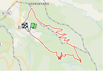
11.8 km | 18.2 km-effort
2h 44min
Yes
Trail Walking Eyne - Eyne,col de Nuria,pic d'Eyne,Torre d'Eyne,Eyne. - Photo
Walking
Machaon6

Walking

Very difficult
(1)
Eyne, Occitania, Pyrénées-Orientales, France
24 km | 43 km-effort
8h 44min
Yes
Trail Walking Eyne - Vallée d'Eyne - Photo
Walking
GUIDE
nadinebondoux

Walking

Medium
Eyne, Occitania, Pyrénées-Orientales, France
10.7 km | 17.6 km-effort
4h 40min
Yes
Trail Walking Eyne - eyne - Photo
Walking
gardelg

Walking

Medium
(2)
Eyne, Occitania, Pyrénées-Orientales, France
6.2 km | 8.2 km-effort
2h 1min
Yes
Trail sport Saillagouse - 20240623 Saillagouse -Err - Photo
sport
ThonyM

sport

Very easy
Saillagouse, Occitania, Pyrénées-Orientales, France
11.9 km | 15.5 km-effort
Unknown
Yes
Trail Walking Eyne - La vallée d'Eyne - Photo
Walking
suresnois

Walking

Difficult
Eyne, Occitania, Pyrénées-Orientales, France
11.2 km | 18 km-effort
7h 8min
Yes
Trail Walking Estavar - 20220328 Estavar-Tartassonne(?) - Photo
Walking
ThonyM

Walking

Medium
Estavar, Occitania, Pyrénées-Orientales, France
14.8 km | 22 km-effort
3h 16min
Yes
Trail Walking Eyne - 20210722 vallée d’Eyne-Pic de Nuria et Finestrelle - Photo
Walking
ThonyM

Walking

Difficult
Eyne, Occitania, Pyrénées-Orientales, France
21 km | 37 km-effort
5h 56min
Yes
Trail Walking Saillagouse - 20210627 à partir de Saillagouse  - Photo
Walking
ThonyM

Walking

Medium
(1)
Saillagouse, Occitania, Pyrénées-Orientales, France
16.2 km | 26 km-effort
3h 47min
Yes


Close
My subscriptions