Trail Running Ascain - Skyrhune 2014 - Photo
© OpenStreetMap contributors
Length
Length
19.8 km
Max alt
Max alt
895 m
Uphill gradient
Uphill gradient
1592 m
Km-Effort
Km-Effort  
41 km
Min alt
Min alt
23 m
Downhill gradient
Downhill gradient
1593 m
Boucle
Boucle
Yes
Creation date :
2014-12-10 00:00:00.0
Updated on :
2014-12-10 00:00:00.0

(1 Reviews)

Running
Running
3h00
Difficulty : Difficult

Scan this QR Code to open this trail in the SityTrail application

FREE GPS app for hiking

Logo SityTrail SityTrail

IGN / Geographical institutes

Download SityTrail from the App Store Download SityTrail from Google Play

Logo SityTrail SityTrail World

The world is yours!

Download SityTrail from the App Store Download SityTrail from Google Play Download SityTrail on Huawei AppGallery

About

Trail Running of 19.8 km to be discovered at New Aquitaine, Pyrénées-Atlantiques, Ascain. This trail is proposed by adorlavie.

Description

Tracé réalisé avec le site web http://tracedetrail.fr

Elevation profile

Positioning

Country:
France
Region :
New Aquitaine
Department/Province :
Pyrénées-Atlantiques
Municipality :
Ascain
Location:
Unknown
Start:(UTM)
611789 ; 4800032 (30T) N.

Comments

Please log in to post a review or rate the element


skyrhun


Trails nearby

Trail Walking Ascain - ascain Sare ascain - Photo
Walking
RayFab

Walking

Medium
(1)
Ascain, New Aquitaine, Pyrénées-Atlantiques, France
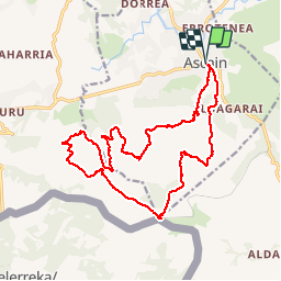
18.8 km | 27 km-effort
4h 39min
Yes
Trail Walking Sare - sare - Photo
Walking
JPLACANAU

Walking

Very easy
(1)
Sare, New Aquitaine, Pyrénées-Atlantiques, France
6.6 km | 8.9 km-effort
2h 22min
No
Trail Walking Saint-Jean-de-Luz - 64 SAINT-JEAN-DE-LUZ, front de mer, pointe ste Barbe, sentier littoral - Photo
Walking
jeff66

Walking

Medium
(1)
Saint-Jean-de-Luz, New Aquitaine, Pyrénées-Atlantiques, France
6.9 km | 8.4 km-effort
1h 57min
Yes
Trail Walking Urrugne - Montagne de Ciboure - Trabenea - Photo
Walking
tracegps

Walking

Medium
(2)
Urrugne, New Aquitaine, Pyrénées-Atlantiques, France
8.6 km | 13.3 km-effort
2h 30min
Yes
Trail Walking Saint-Pée-sur-Nivelle - Uhartea 22   - Photo
Walking
tracegps

Walking

Very difficult
(1)
Saint-Pée-sur-Nivelle, New Aquitaine, Pyrénées-Atlantiques, France
22 km | 31 km-effort
7h 0min
Yes
Trail Walking Sare - La rhune par la face EST - Photo
Walking
DECHAMPD

Walking

Medium
(1)
Sare, New Aquitaine, Pyrénées-Atlantiques, France
13.8 km | 26 km-effort
5h 10min
Yes
Trail Walking Sare - la rhune depuis Sare (2) - Photo
Walking
jcaudron

Walking

Very easy
(4)
Sare, New Aquitaine, Pyrénées-Atlantiques, France
13.9 km | 26 km-effort
4h 0min
Yes
Trail Walking Urrugne - rhune - Photo
Walking
phil331

Walking

Medium
(1)
Urrugne, New Aquitaine, Pyrénées-Atlantiques, France
11.9 km | 24 km-effort
4h 43min
Yes
Trail Mountain bike Urrugne - 64-Olhette-20110417 - Photo
Mountain bike
Gus64

Mountain bike

Difficult
(2)
Urrugne, New Aquitaine, Pyrénées-Atlantiques, France
33 km | 49 km-effort
3h 30min
Yes


Close
My subscriptions