Trail Walking Saint-Martin-en-Vercors - Saint Martin en Vercors  - Photo
 meillon
meillon

User

© OpenStreetMap contributors
Length
Length
8.5 km
Max alt
Max alt
1185 m
Uphill gradient
Uphill gradient
254 m
Km-Effort
Km-Effort  
11.8 km
Min alt
Min alt
999 m
Downhill gradient
Downhill gradient
254 m
Boucle
Boucle
Yes
Creation date :
2022-06-25 10:19:54.017
Updated on :
2022-06-25 14:17:41.872

(0 Reviews)

Walking
Walking
3h57
Difficulty : Easy

Scan this QR Code to open this trail in the SityTrail application

FREE GPS app for hiking

Logo SityTrail SityTrail

IGN / Geographical institutes

Download SityTrail from the App Store Download SityTrail from Google Play

Logo SityTrail SityTrail World

The world is yours!

Download SityTrail from the App Store Download SityTrail from Google Play Download SityTrail on Huawei AppGallery

About

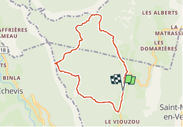
Trail Walking of 8.5 km to be discovered at Auvergne-Rhône-Alpes, Drôme, Saint-Martin-en-Vercors. This trail is proposed by meillon.

Description

montee vers le pas de l Allier puis aperçu du barrage de la Bourne et retour avec vue sur le Veymont...parcours forestier très agréable

Elevation profile

Positioning

Country:
France
Region :
Auvergne-Rhône-Alpes
Department/Province :
Drôme
Municipality :
Saint-Martin-en-Vercors
Location:
Unknown
Start:(UTM)
690868 ; 4988763 (31T) N.

Trails nearby

Trail Walking Châtelus - 38 bournillon porte du diable charmatte - Photo
Walking
GUIDE
randodyssée

Walking

Difficult
(1)
Châtelus, Auvergne-Rhône-Alpes, Isère, France
16.5 km | 34 km-effort
8h 7min
Yes
Trail Walking La Chapelle-en-Vercors - Belvedere de la Révoulat - Photo
Walking
simon.paume

Walking

Easy
(1)
La Chapelle-en-Vercors, Auvergne-Rhône-Alpes, Drôme, France
5.3 km | 10.6 km-effort
2h 5min
Yes
Trail Walking Châtelus - Boucle Pas de l'Allier - Pas des Voutes - Photo
Walking
tracegps

Walking

Medium
(1)
Châtelus, Auvergne-Rhône-Alpes, Isère, France
10.1 km | 22 km-effort
4h 30min
Yes
Trail Walking Saint-Laurent-en-Royans - 26 rocher des mines ARP - Photo
Walking
GUIDE
randodyssée

Walking

Very difficult
Saint-Laurent-en-Royans, Auvergne-Rhône-Alpes, Drôme, France
8.6 km | 16.2 km-effort
6h 53min
Yes
Trail Walking Châtelus - 38 pabro charmatte - Photo
Walking
GUIDE
randodyssée

Walking

Difficult
Châtelus, Auvergne-Rhône-Alpes, Isère, France
11.4 km | 29 km-effort
7h 43min
Yes
Trail Walking Châtelus - la grande cournouse - Photo
Walking
GUIDE
nadd73

Walking

Difficult
Châtelus, Auvergne-Rhône-Alpes, Isère, France
10.5 km | 26 km-effort
6h 34min
Yes
Trail Walking Châtelus - la grotte des Gaulois, le pas de l' Echarasson, porte du diable, pas de charmate - Photo
Walking
GUIDE
nadd73

Walking

Difficult
Châtelus, Auvergne-Rhône-Alpes, Isère, France
18.3 km | 37 km-effort
8h 23min
Yes
Trail Walking Choranche - Presles grotte de Gournier et de balme rousse - Photo
Walking
GUIDE
nadd73

Walking

Medium
Choranche, Auvergne-Rhône-Alpes, Isère, France
5.5 km | 14.6 km-effort
3h 19min
Yes
Trail Other activity Saint-Martin-en-Vercors - Cournouses pas de l'allier - Photo
Other activity
collot

Other activity

Medium
(1)
Saint-Martin-en-Vercors, Auvergne-Rhône-Alpes, Drôme, France
11 km | 21 km-effort
5h 0min
Yes


Close
My subscriptions