![](/images/other/stat-length.png)
![Trail Walking Saint-Mars-de-Coutais - Circuit du Tenu - Photo](https://media.geolcdn.com/t/1900/400/ext.pjpeg?maxdim=2&url=https%3A%2F%2Fstatic1.geolcdn.com%2Fsiteimages%2Fupload%2Ffiles%2F1553511878bg_sport_marche.png)
Circuit du Tenu
neoroll44
User
![Length](/images/other/stat-length.png)
![Max alt](https://static1.geolcdn.com/siteimages/upload/files/1508320355ic_sort_altitude_max_24dp.png)
![Uphill gradient](https://static1.geolcdn.com/siteimages/upload/files/1508320355ic_sort_den_pos_24dp.png)
![Km-Effort](/images/other/stat-length.png)
![Min alt](https://static1.geolcdn.com/siteimages/upload/files/1508320355ic_sort_altitude_min_24dp.png)
![Downhill gradient](https://static1.geolcdn.com/siteimages/upload/files/1508320355ic_sort_den_neg_24dp.png)
![Boucle](https://static1.geolcdn.com/siteimages/upload/files/16400158638029165_repeat_loop_refresh_sync_direction_icon.png)
![Walking](https://static1.geolcdn.com/sitytour/trail-icons/101.png)
3h10
Difficulty : Medium
![Scan this QR Code to open this trail in the SityTrail application](https://capi.geolives.com/qq0zvz2zws4bq2lad0pu/sitytour/trails/3293746/qr.png?size=200)
FREE GPS app for hiking
About
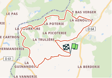
Trail Walking of 10.9 km to be discovered at Pays de la Loire, Loire-Atlantique, Saint-Mars-de-Coutais. This trail is proposed by neoroll44.
Description
Panneau de départ et stationnement : Les Grandes Vignes.
(D/A) Continuez tout droit Nord-Ouest. Longez le champ de blé jusqu’à un croisement
(1) Prenez à droite et poursuivez dans les vignes jusqu’au bout du chemin.
(2) Prenez à gauche sur ce chemin. Traversez prudemment la route et poursuivez en face jusqu’à une nouvelle intersection.
(3) Bifurquez sur votre gauche en poursuivant dans le virage.
(4) Arrivez sur la route, prenez sur votre gauche sur 150 m environ et tournez à droite dans le Chemin du Marais Gabarre à l’entrée de la Renourie.
(5) Dans le virage, tournez à gauche puis, un peu plus loin, à la Baffrie, bifurquez sur votre droite plein Ouest. Laissez les hameaux à main gauche.
(6) Arrivez à une autre route, tournez à droite sur celle-ci. Passez sous une ligne électrique.
(7) Empruntez ensuite le chemin boisé sur votre droite.
(8) Après les premières maisons de la Bourrière, tournez à droite, puis à nouveau à droite à quelques mètres. Retrouvez plus loin une nouvelle route.
(9) Prenez-la à droite sur environ 300 m, puis poursuivre le chemin à gauche. À la route, partez à gauche vers la Trancherie, puis poursuivez par un chemin qui prolonge cette route dans un virage à droite.
(10) À la route, bifurquez à droite sur la route puis dans le chemin rural à gauche, dans les vignes. Au bout effectuez un gauche/droite et rejoindre un autre chemin. Partez à gauche sur celui-ci pour rejoindre les Grandes Vignes (D/A).
Points of interest
Positioning
Comments
Trails nearby
![Trail On foot Saint-Mars-de-Coutais - Les Landas - Photo](https://media.geolcdn.com/t/375/260/cc8bcb90-39c4-4580-8ca7-9e86e87822c7.jpeg&format=jpg&maxdim=2)
![On foot On foot](https://static1.geolcdn.com/sitytour/trail-icons/100.png)
On foot
![](/images/other/stat-length.png)
![](https://static1.geolcdn.com/siteimages/upload/files/16400158638029165_repeat_loop_refresh_sync_direction_icon.png)
![Trail On foot Saint-Lumine-de-Coutais - La Robrie - Photo](https://media.geolcdn.com/t/375/260/bc5bacd4-f52e-4a17-96b9-265a164421df.jpeg&format=jpg&maxdim=2)
![On foot On foot](https://static1.geolcdn.com/sitytour/trail-icons/100.png)
On foot
![](/images/other/stat-length.png)
![](https://static1.geolcdn.com/siteimages/upload/files/16400158638029165_repeat_loop_refresh_sync_direction_icon.png)
![Trail Walking Sainte-Pazanne - Ste Pazanne_Coulée_Aqueduc - Photo](https://media.geolcdn.com/t/375/260/ext.jpg?maxdim=2&url=https%3A%2F%2Fservices.sitytrail.com%2FGeolivesWS%2FDownloadMedia.ashx%3FTrailID%3D580011%26Media%3D525ac128-9a89-4ccf-890c-fc7a28420256.jpg)
![Walking Walking](https://static1.geolcdn.com/sitytour/trail-icons/101.png)
Walking
![](/images/other/stat-length.png)
![](https://static1.geolcdn.com/siteimages/upload/files/16400158638029165_repeat_loop_refresh_sync_direction_icon.png)
![Trail Walking Saint-Mars-de-Coutais - Circuit du Bois Charrette - Photo](https://media.geolcdn.com/t/375/260/ext.jpg?maxdim=2&url=https%3A%2F%2Fstatic1.geolcdn.com%2Fsiteimages%2Fupload%2Ffiles%2F1553511878bg_sport_marche.png)
![Walking Walking](https://static1.geolcdn.com/sitytour/trail-icons/101.png)
Walking
![](/images/other/stat-length.png)
![](https://static1.geolcdn.com/siteimages/upload/files/16400158638029165_repeat_loop_refresh_sync_direction_icon.png)
![Trail On foot Saint-Mars-de-Coutais - Le Moulin de la Nation - Photo](https://media.geolcdn.com/t/375/260/ext.jpg?maxdim=2&url=https%3A%2F%2Fstatic1.geolcdn.com%2Fsiteimages%2Fupload%2Ffiles%2F1545311037marcheuse_200dpi.jpg)
![On foot On foot](https://static1.geolcdn.com/sitytour/trail-icons/100.png)
On foot
![](/images/other/stat-length.png)
![](https://static1.geolcdn.com/siteimages/upload/files/16400158638029165_repeat_loop_refresh_sync_direction_icon.png)
![Trail Walking Sainte-Pazanne - Ste Pazanne - Photo](https://media.geolcdn.com/t/375/260/ext.jpg?maxdim=2&url=https%3A%2F%2Fstatic1.geolcdn.com%2Fsiteimages%2Fupload%2Ffiles%2F1553511878bg_sport_marche.png)
![Walking Walking](https://static1.geolcdn.com/sitytour/trail-icons/101.png)
Walking
![](/images/other/stat-length.png)
![](https://static1.geolcdn.com/siteimages/upload/files/16400158638029165_repeat_loop_refresh_sync_direction_icon.png)
![Trail On foot Port-Saint-Père - planète sauvage - Photo](https://media.geolcdn.com/t/375/260/ext.jpg?maxdim=2&url=https%3A%2F%2Fstatic1.geolcdn.com%2Fsiteimages%2Fupload%2Ffiles%2F1545311037marcheuse_200dpi.jpg)
![On foot On foot](https://static1.geolcdn.com/sitytour/trail-icons/100.png)
On foot
![](/images/other/stat-length.png)
![](https://static1.geolcdn.com/siteimages/upload/files/16400158638029165_repeat_loop_refresh_sync_direction_icon.png)