Trail Walking Les Éparges - Éparges Sentier monuments  - Photo

Éparges Sentier monuments

 sgazaix
sgazaix

User

© OpenStreetMap contributors
Length
Length
5.7 km
Max alt
Max alt
356 m
Uphill gradient
Uphill gradient
112 m
Km-Effort
Km-Effort  
7.1 km
Min alt
Min alt
260 m
Downhill gradient
Downhill gradient
110 m
Boucle
Boucle
Yes
Creation date :
2022-06-24 07:28:24.578
Updated on :
2022-06-24 09:15:40.231

(0 Reviews)

Walking
Walking
1h19
Difficulty : Easy

Scan this QR Code to open this trail in the SityTrail application

FREE GPS app for hiking

Logo SityTrail SityTrail

IGN / Geographical institutes

Download SityTrail from the App Store Download SityTrail from Google Play

Logo SityTrail SityTrail World

The world is yours!

Download SityTrail from the App Store Download SityTrail from Google Play Download SityTrail on Huawei AppGallery

About

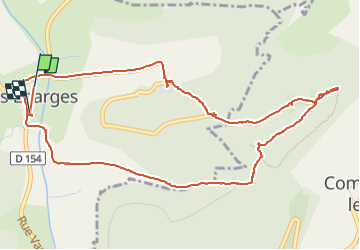
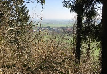
Trail Walking of 5.7 km to be discovered at Grand Est, Meuse, Les Éparges. This trail is proposed by sgazaix.

Description

entonnoirs Point X Monument du Coq

Elevation profile

Positioning

Country:
France
Region :
Grand Est
Department/Province :
Meuse
Municipality :
Les Éparges
Location:
Unknown
Start:(UTM)
689512 ; 5437986 (31U) N.

Trails nearby

Trail Horseback riding Hannonville-sous-les-Côtes - hattonchatel - Photo
Horseback riding
jcvmax

Horseback riding

Medium
(1)
Hannonville-sous-les-Côtes, Grand Est, Meuse, France
22 km | 27 km-effort
3h 31min
Yes
Trail Equestrian Dommartin-la-Montagne - SityTrail - SityTrail - trace - Photo
Equestrian
ochelen

Equestrian

Medium
(2)
Dommartin-la-Montagne, Grand Est, Meuse, France
27 km | 34 km-effort
Unknown
Yes
Trail Walking Dommartin-la-Montagne - 8mars15 Herbeuville - Photo
Walking
dominique.husson

Walking

Easy
Dommartin-la-Montagne, Grand Est, Meuse, France
4 km | 5.2 km-effort
1h 35min
Yes
Trail Cycle Bonzée - Circuit n°1, Les Côtes de Meuse et la vallée du Longeau - Photo
Cycle
tracegps

Cycle

Difficult
Bonzée, Grand Est, Meuse, France
43 km | 50 km-effort
2h 30min
Yes
Trail Cycle Bonzée - Circuit n°1, Les Côtes de Meuse au pays des Coutiats - Photo
Cycle
tracegps

Cycle

Medium
Bonzée, Grand Est, Meuse, France
29 km | 34 km-effort
1h 30min
Yes
Trail Walking Les Éparges - les éparges- variantes - Photo
Walking
bohynm

Walking

Very easy
Les Éparges, Grand Est, Meuse, France
10.2 km | 13.5 km-effort
2h 54min
Yes
Trail Horseback riding Hannonville-sous-les-Côtes - Etang de Longeau-Lac de Madine  - Photo
Horseback riding
claude-aei

Horseback riding

Difficult
Hannonville-sous-les-Côtes, Grand Est, Meuse, France
27 km | 32 km-effort
4h 10min
No
Trail Walking Les Éparges - les eparges - Photo
Walking
jcb48

Walking

Medium
Les Éparges, Grand Est, Meuse, France
7.1 km | 8.8 km-effort
2h 27min
Yes
Trail sport Hannonville-sous-les-Côtes - Sabine et Francoise  - Photo
sport
Sabine Poignant

sport

Very easy
Hannonville-sous-les-Côtes, Grand Est, Meuse, France
9.7 km | 10.9 km-effort
Unknown
No


Close
My subscriptions