![](/images/other/stat-length.png)
![Trail Walking Aillon-le-Jeune - Bauges le Colombier et des crêtes - Photo](https://media.geolcdn.com/t/1900/400/ext.pjpeg?maxdim=2&url=https%3A%2F%2Fstatic1.geolcdn.com%2Fsiteimages%2Fupload%2Ffiles%2F1553511878bg_sport_marche.png)
Bauges le Colombier et des crêtes
c.gourme
User
![Length](/images/other/stat-length.png)
Length
14.2 km
![Max alt](https://static1.geolcdn.com/siteimages/upload/files/1508320355ic_sort_altitude_max_24dp.png)
Max alt
2030 m
![Uphill gradient](https://static1.geolcdn.com/siteimages/upload/files/1508320355ic_sort_den_pos_24dp.png)
Uphill gradient
1057 m
![Km-Effort](/images/other/stat-length.png)
Km-Effort
28 km
![Min alt](https://static1.geolcdn.com/siteimages/upload/files/1508320355ic_sort_altitude_min_24dp.png)
Min alt
1181 m
![Downhill gradient](https://static1.geolcdn.com/siteimages/upload/files/1508320355ic_sort_den_neg_24dp.png)
Downhill gradient
1049 m
![Boucle](https://static1.geolcdn.com/siteimages/upload/files/16400158638029165_repeat_loop_refresh_sync_direction_icon.png)
Boucle
Yes
Creation date :
2022-06-21 06:35:07.0
Updated on :
2022-10-05 16:44:50.568
![Walking](https://static1.geolcdn.com/sitytour/trail-icons/101.png)
5h35
Difficulty : Medium
![Scan this QR Code to open this trail in the SityTrail application](https://capi.geolives.com/qq0zvz2zws4bq2lad0pu/sitytour/trails/3290353/qr.png?size=200)
FREE GPS app for hiking
About
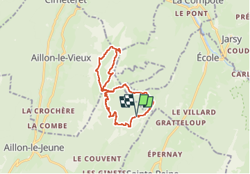
Trail Walking of 14.2 km to be discovered at Auvergne-Rhône-Alpes, Savoy, Aillon-le-Jeune. This trail is proposed by c.gourme.
Description
Attention il peut y avoir des Patous! Préférer la montée en aller retour par les chalets de la Fullie, c'est beaucoup plus joli.
Positioning
Country:
France
Region :
Auvergne-Rhône-Alpes
Department/Province :
Savoy
Municipality :
Aillon-le-Jeune
Location:
Unknown
Start:(Dec)
Start:(UTM)
276392 ; 5056931 (32T) N.
Comments
Trails nearby
![Trail Walking Jarsy - BAUGES: PRECHEREL - CROIX D'ALLANT - PLAN DE LA LIMACE - en direction du Mont de la Coche - Photo](https://media.geolcdn.com/t/375/260/a1c1a220-f26a-4fbe-a6ad-eda1f1982f07.jpg&format=jpg&maxdim=2)
![Walking Walking](https://static1.geolcdn.com/sitytour/trail-icons/101.png)
BAUGES: PRECHEREL - CROIX D'ALLANT - PLAN DE LA LIMACE - en direction du Mont...
Walking
Difficult
(1)
Jarsy,
Auvergne-Rhône-Alpes,
Savoy,
France
![](/images/other/stat-length.png)
13.1 km | 24 km-effort
4h 45min
![](https://static1.geolcdn.com/siteimages/upload/files/16400158638029165_repeat_loop_refresh_sync_direction_icon.png)
Yes
![Trail Walking Le Châtelard - Roc poyet - Photo](https://media.geolcdn.com/t/375/260/a503fd55-09ac-42bc-9003-547472a05706.jpg&format=jpg&maxdim=2)
![Walking Walking](https://static1.geolcdn.com/sitytour/trail-icons/101.png)
Roc poyet
Walking
Medium
Le Châtelard,
Auvergne-Rhône-Alpes,
Savoy,
France
![](/images/other/stat-length.png)
8.2 km | 19.8 km-effort
5h 6min
![](https://static1.geolcdn.com/siteimages/upload/files/16400158638029165_repeat_loop_refresh_sync_direction_icon.png)
Yes
![Trail Walking Aillon-le-Jeune - Rochers de Barde - Photo](https://media.geolcdn.com/t/375/260/48940505-c84c-4f22-8bea-360415ea5442.jpg&format=jpg&maxdim=2)
![Walking Walking](https://static1.geolcdn.com/sitytour/trail-icons/101.png)
Rochers de Barde
Walking
Medium
Aillon-le-Jeune,
Auvergne-Rhône-Alpes,
Savoy,
France
![](/images/other/stat-length.png)
11.7 km | 24 km-effort
6h 25min
![](https://static1.geolcdn.com/siteimages/upload/files/16400158638029165_repeat_loop_refresh_sync_direction_icon.png)
Yes
![Trail Walking Aillon-le-Jeune - Colombier par rocher de la Bade et Cochette, retour par la Fulie - Photo](https://media.geolcdn.com/t/375/260/ext.jpg?maxdim=2&url=https%3A%2F%2Fstatic1.geolcdn.com%2Fsiteimages%2Fupload%2Ffiles%2F1553511878bg_sport_marche.png)
![Walking Walking](https://static1.geolcdn.com/sitytour/trail-icons/101.png)
Colombier par rocher de la Bade et Cochette, retour par la Fulie
Walking
Very easy
(2)
Aillon-le-Jeune,
Auvergne-Rhône-Alpes,
Savoy,
France
![](/images/other/stat-length.png)
17.7 km | 35 km-effort
6h 4min
![](https://static1.geolcdn.com/siteimages/upload/files/16400158638029165_repeat_loop_refresh_sync_direction_icon.png)
Yes
![Trail Walking Jarsy - nôtre dame de Bellevaux - Photo](https://media.geolcdn.com/t/375/260/1be31ea5-d3d1-459b-88d3-6aa2e29612aa.jpg&format=jpg&maxdim=2)
![Walking Walking](https://static1.geolcdn.com/sitytour/trail-icons/101.png)
nôtre dame de Bellevaux
Walking
Very easy
Jarsy,
Auvergne-Rhône-Alpes,
Savoy,
France
![](/images/other/stat-length.png)
5.2 km | 7.9 km-effort
1h 28min
![](https://static1.geolcdn.com/siteimages/upload/files/16400158638029165_repeat_loop_refresh_sync_direction_icon.png)
Yes
![Walking Walking](https://static1.geolcdn.com/sitytour/trail-icons/101.png)
Croix d'Allant et Plan de la Limace
Walking
Very difficult
Jarsy,
Auvergne-Rhône-Alpes,
Savoy,
France
![](/images/other/stat-length.png)
14.6 km | 26 km-effort
6h 29min
![](https://static1.geolcdn.com/siteimages/upload/files/16400158638029165_repeat_loop_refresh_sync_direction_icon.png)
Yes
![Trail Walking Aillon-le-Jeune - Petit circuit découverte aillon le jeune - Photo](https://media.geolcdn.com/t/375/260/9feb56d6-5072-42da-bdbc-71a62ee2fe47.jpg&format=jpg&maxdim=2)
![Walking Walking](https://static1.geolcdn.com/sitytour/trail-icons/101.png)
Petit circuit découverte aillon le jeune
Walking
Very easy
Aillon-le-Jeune,
Auvergne-Rhône-Alpes,
Savoy,
France
![](/images/other/stat-length.png)
5.9 km | 8.9 km-effort
1h 59min
![](https://static1.geolcdn.com/siteimages/upload/files/16400158638029165_repeat_loop_refresh_sync_direction_icon.png)
Yes
![Trail Touring skiing École - pointe des Arlicots - Photo](https://media.geolcdn.com/t/375/260/7ea3a78f-9737-4674-ba73-476172d62101.jpg&format=jpg&maxdim=2)
![Touring skiing Touring skiing](https://static1.geolcdn.com/sitytour/trail-icons/503.png)
pointe des Arlicots
Touring skiing
Medium
École,
Auvergne-Rhône-Alpes,
Savoy,
France
![](/images/other/stat-length.png)
9.2 km | 23 km-effort
4h 56min
![](https://static1.geolcdn.com/siteimages/upload/files/16400158638029165_repeat_loop_refresh_sync_direction_icon.png)
No
![Trail Walking Aillon-le-Vieux - col colombier - Photo](https://media.geolcdn.com/t/375/260/e2b5f89d-50b0-4b1d-ae97-04fc8e08fc45.jpg&format=jpg&maxdim=2)
![Walking Walking](https://static1.geolcdn.com/sitytour/trail-icons/101.png)
col colombier
Walking
Medium
Aillon-le-Vieux,
Auvergne-Rhône-Alpes,
Savoy,
France
![](/images/other/stat-length.png)
9.4 km | 21 km-effort
3h 5min
![](https://static1.geolcdn.com/siteimages/upload/files/16400158638029165_repeat_loop_refresh_sync_direction_icon.png)
Yes