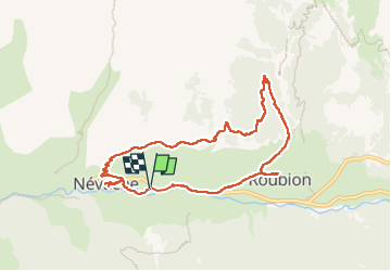
15.5 km | 28 km-effort
balcon de nevache
RayFab
User
Length
8.9 km
Max alt
1855 m
Uphill gradient
317 m
Km-Effort
13.1 km
Min alt
1585 m
Downhill gradient
318 m
Boucle
Yes
Creation date :
2022-06-21 06:33:43.612
Updated on :
2022-06-22 05:08:48.336
3h02
Difficulty : Easy
FREE GPS app for hiking
About
Trail Walking of 8.9 km to be discovered at Provence-Alpes-Côte d'Azur, Hautes-Alpes, Névache. This trail is proposed by RayFab.
Description
Magnifique randonnée sur les hauteurs de Névache pour finir par une descente au milieu des bois. Balade facile
Positioning
Country:
France
Region :
Provence-Alpes-Côte d'Azur
Department/Province :
Hautes-Alpes
Municipality :
Névache
Location:
Unknown
Start:(Dec)
Start:(UTM)
311782 ; 4987774 (32T) N.
Comments
Trails nearby
Via Alpina - R127: Névache > Le Monêtier-les-Bains
Walking
Difficult
(1)
Névache,
Provence-Alpes-Côte d'Azur,
Hautes-Alpes,
France
5h 0min
No
LA CLAREE: balcon de la claree
Walking
Medium
Névache,
Provence-Alpes-Côte d'Azur,
Hautes-Alpes,
France
14.2 km | 23 km-effort
4h 7min
Yes
Col des Thures - Lac Chavillon
Walking
Medium
Névache,
Provence-Alpes-Côte d'Azur,
Hautes-Alpes,
France
5.3 km | 11.1 km-effort
2h 31min
No
Les lacs de Chavillon et Beletty par le col des Thures
Walking
Medium
Névache,
Provence-Alpes-Côte d'Azur,
Hautes-Alpes,
France
12.1 km | 21 km-effort
6h 5min
No
J2 2023 - Névache : Le Grand Area
Walking
Very difficult
Névache,
Provence-Alpes-Côte d'Azur,
Hautes-Alpes,
France
23 km | 43 km-effort
6h 58min
Yes
nevache VTT 47 échelle vallée étroite
Mountain bike
Difficult
Névache,
Provence-Alpes-Côte d'Azur,
Hautes-Alpes,
France
25 km | 38 km-effort
2h 58min
Yes
Nevache2
Walking
Medium
Névache,
Provence-Alpes-Côte d'Azur,
Hautes-Alpes,
France
13.1 km | 25 km-effort
8h 53min
Yes
Nevache 1
Walking
Medium
Névache,
Provence-Alpes-Côte d'Azur,
Hautes-Alpes,
France
13.5 km | 23 km-effort
6h 49min
Yes
roche gauthier couloir nord
Touring skiing
Difficult
Névache,
Provence-Alpes-Côte d'Azur,
Hautes-Alpes,
France
12.5 km | 27 km-effort
3h 6min
Yes
jolie balade