![](/images/other/stat-length.png)
20220620 - Aubel 7.2 Km
pierreh01
User GUIDE
![Length](/images/other/stat-length.png)
Length
7.1 km
![Max alt](https://static1.geolcdn.com/siteimages/upload/files/1508320355ic_sort_altitude_max_24dp.png)
Max alt
275 m
![Uphill gradient](https://static1.geolcdn.com/siteimages/upload/files/1508320355ic_sort_den_pos_24dp.png)
Uphill gradient
110 m
![Km-Effort](/images/other/stat-length.png)
Km-Effort
8.6 km
![Min alt](https://static1.geolcdn.com/siteimages/upload/files/1508320355ic_sort_altitude_min_24dp.png)
Min alt
205 m
![Downhill gradient](https://static1.geolcdn.com/siteimages/upload/files/1508320355ic_sort_den_neg_24dp.png)
Downhill gradient
111 m
![Boucle](https://static1.geolcdn.com/siteimages/upload/files/16400158638029165_repeat_loop_refresh_sync_direction_icon.png)
Boucle
Yes
Creation date :
2022-06-20 12:02:13.647
Updated on :
2022-06-21 19:40:37.338
![Walking](https://static1.geolcdn.com/sitytour/trail-icons/101.png)
2h06
Difficulty : Medium
![Scan this QR Code to open this trail in the SityTrail application](https://capi.geolives.com/qq0zvz2zws4bq2lad0pu/sitytour/trails/3288956/qr.png?size=200)
FREE GPS app for hiking
About
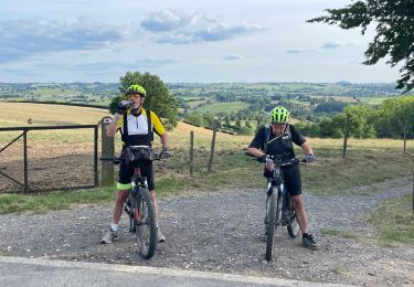
Trail Walking of 7.1 km to be discovered at Wallonia, Liège, Aubel. This trail is proposed by pierreh01.
Description
Lundi 20 juin 2022 : Balade hebdomadaire des "BIOS"
Au départ de Aubel, sous la direction de Gérard, circuit en boucle largement inspirée de la Balade de Saint-Hubert de la Maison du Tourisme du Pays de Herve.
A travers champs, sentiers et route sous une météo très agréable.
Positioning
Country:
Belgium
Region :
Wallonia
Department/Province :
Liège
Municipality :
Aubel
Location:
Unknown
Start:(Dec)
Start:(UTM)
701812 ; 5620976 (31U) N.
Comments
Trails nearby
![Trail Walking Plombières - Hombourg. Natura 2000, des sites qui valent le détour ! Lg6 - Photo](https://media.geolcdn.com/t/375/260/ext.jpg?maxdim=2&url=https%3A%2F%2Fservices.sitytrail.com%2FGeolivesWS%2FDownloadMedia.ashx%3FTrailID%3D142693%26Media%3D08dbd372-9409-44af-92fd-51b9576d1e78.JPG)
![Walking Walking](https://static1.geolcdn.com/sitytour/trail-icons/101.png)
Hombourg. Natura 2000, des sites qui valent le détour ! Lg6
Walking
Easy
(10)
Plombières,
Wallonia,
Liège,
Belgium
![](/images/other/stat-length.png)
9.5 km | 12 km-effort
2h 35min
![](https://static1.geolcdn.com/siteimages/upload/files/16400158638029165_repeat_loop_refresh_sync_direction_icon.png)
Yes
![Trail Walking Aubel - autour de val dieu - Photo](https://media.geolcdn.com/t/375/260/fd89e5f6-352d-4ec8-ac99-e9175fe8e322.jpg&format=jpg&maxdim=2)
![Walking Walking](https://static1.geolcdn.com/sitytour/trail-icons/101.png)
autour de val dieu
Walking
Very easy
(6)
Aubel,
Wallonia,
Liège,
Belgium
![](/images/other/stat-length.png)
9.5 km | 12.1 km-effort
2h 13min
![](https://static1.geolcdn.com/siteimages/upload/files/16400158638029165_repeat_loop_refresh_sync_direction_icon.png)
Yes
![Trail Walking Thimister-Clermont - La Minerie - Photo](https://media.geolcdn.com/t/375/260/ext.jpg?maxdim=2&url=https%3A%2F%2Fstatic1.geolcdn.com%2Fsiteimages%2Fupload%2Ffiles%2F1553511878bg_sport_marche.png)
![Walking Walking](https://static1.geolcdn.com/sitytour/trail-icons/101.png)
La Minerie
Walking
Easy
(6)
Thimister-Clermont,
Wallonia,
Liège,
Belgium
![](/images/other/stat-length.png)
12.9 km | 15.7 km-effort
3h 22min
![](https://static1.geolcdn.com/siteimages/upload/files/16400158638029165_repeat_loop_refresh_sync_direction_icon.png)
Yes
![Trail Walking Thimister-Clermont - Froidthier - Photo](https://media.geolcdn.com/t/375/260/9142f7fe-feb5-4533-8005-65992f1c4338.jpg&format=jpg&maxdim=2)
![Walking Walking](https://static1.geolcdn.com/sitytour/trail-icons/101.png)
Froidthier
Walking
Easy
(1)
Thimister-Clermont,
Wallonia,
Liège,
Belgium
![](/images/other/stat-length.png)
6.6 km | 7.9 km-effort
1h 48min
![](https://static1.geolcdn.com/siteimages/upload/files/16400158638029165_repeat_loop_refresh_sync_direction_icon.png)
Yes
![Trail Walking Voeren - 2022-11-11_17h35m36_wandelroute-de-voerstreek-mooiste - Photo](https://media.geolcdn.com/t/375/260/3df743f8-88e4-4c10-a47a-c05fdf0072fe.jpg&format=jpg&maxdim=2)
![Walking Walking](https://static1.geolcdn.com/sitytour/trail-icons/101.png)
2022-11-11_17h35m36_wandelroute-de-voerstreek-mooiste
Walking
Medium
(1)
Voeren,
Flanders,
Limburg,
Belgium
![](/images/other/stat-length.png)
9.3 km | 12.5 km-effort
2h 49min
![](https://static1.geolcdn.com/siteimages/upload/files/16400158638029165_repeat_loop_refresh_sync_direction_icon.png)
Yes
![Trail Walking Voeren - La Commanderie 7 - Photo](https://media.geolcdn.com/t/375/260/e2b67305-0779-4cca-9070-82e3402cc790.jpg&format=jpg&maxdim=2)
![Walking Walking](https://static1.geolcdn.com/sitytour/trail-icons/101.png)
La Commanderie 7
Walking
Easy
(1)
Voeren,
Flanders,
Limburg,
Belgium
![](/images/other/stat-length.png)
4.5 km | 6.3 km-effort
1h 26min
![](https://static1.geolcdn.com/siteimages/upload/files/16400158638029165_repeat_loop_refresh_sync_direction_icon.png)
Yes
![Trail Walking Thimister-Clermont - 2021-03-21_09h09m37_1413 - Photo](https://media.geolcdn.com/t/375/260/2cdc1fed-57d0-4e96-9f7c-8bfb9eab2451.jpg&format=jpg&maxdim=2)
![Walking Walking](https://static1.geolcdn.com/sitytour/trail-icons/101.png)
2021-03-21_09h09m37_1413
Walking
Easy
(2)
Thimister-Clermont,
Wallonia,
Liège,
Belgium
![](/images/other/stat-length.png)
11.1 km | 13.6 km-effort
3h 5min
![](https://static1.geolcdn.com/siteimages/upload/files/16400158638029165_repeat_loop_refresh_sync_direction_icon.png)
Yes
![Trail Walking Aubel - RB-Lg-04 - Raccourci - À travers le bocage aubelois - Photo](https://media.geolcdn.com/t/375/260/ext.jpg?maxdim=2&url=https%3A%2F%2Fservices.sitytrail.com%2FGeolivesWS%2FDownloadMedia.ashx%3FTrailID%3D209393%26Media%3D9ac6c0af-9a08-4948-b5d5-06a09e8ba132.jpg)
![Walking Walking](https://static1.geolcdn.com/sitytour/trail-icons/101.png)
RB-Lg-04 - Raccourci - À travers le bocage aubelois
Walking
Medium
(4)
Aubel,
Wallonia,
Liège,
Belgium
![](/images/other/stat-length.png)
17.1 km | 22 km-effort
4h 50min
![](https://static1.geolcdn.com/siteimages/upload/files/16400158638029165_repeat_loop_refresh_sync_direction_icon.png)
Yes
![Trail Mountain bike Aubel - 20220727 Yeyette à Gorhez - Photo](https://media.geolcdn.com/t/375/260/3e91e36a-9872-4e44-80fe-5903cdab6ed3.jpg&format=jpg&maxdim=2)
![Mountain bike Mountain bike](https://static1.geolcdn.com/sitytour/trail-icons/202.png)
20220727 Yeyette à Gorhez
Mountain bike
Medium
(1)
Aubel,
Wallonia,
Liège,
Belgium
![](/images/other/stat-length.png)
33 km | 41 km-effort
2h 33min
![](https://static1.geolcdn.com/siteimages/upload/files/16400158638029165_repeat_loop_refresh_sync_direction_icon.png)
Yes