Trail Road bike Baratier - Petit Liou Rencuraux Sandrine - Photo

Petit Liou Rencuraux Sandrine

© OpenStreetMap contributors
Length
Length
27 km
Max alt
Max alt
1223 m
Uphill gradient
Uphill gradient
669 m
Km-Effort
Km-Effort  
36 km
Min alt
Min alt
782 m
Downhill gradient
Downhill gradient
672 m
Boucle
Boucle
Yes
Creation date :
2022-06-20 08:19:07.0
Updated on :
2022-06-20 13:58:17.46

(0 Reviews)

Road bike
Road bike
5h38
Difficulty : Medium

Scan this QR Code to open this trail in the SityTrail application

FREE GPS app for hiking

Logo SityTrail SityTrail

IGN / Geographical institutes

Download SityTrail from the App Store Download SityTrail from Google Play

Logo SityTrail SityTrail World

The world is yours!

Download SityTrail from the App Store Download SityTrail from Google Play Download SityTrail on Huawei AppGallery

About

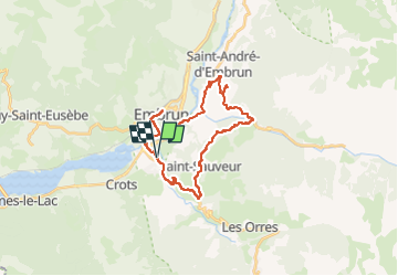
Trail Road bike of 27 km to be discovered at Provence-Alpes-Côte d'Azur, Hautes-Alpes, Baratier. This trail is proposed by Reichling.

Description

Visite à Sandrine Chambre d'Orel par là montagne. Très beau tour. Retour par Embrun.

Elevation profile

Positioning

Country:
France
Region :
Provence-Alpes-Côte d'Azur
Department/Province :
Hautes-Alpes
Municipality :
Baratier
Location:
Unknown
Start:(UTM)
300899 ; 4935475 (32T) N.

Trails nearby

Trail Walking Saint-Sauveur - 2012-08-07 Méale - Photo
Walking
Tchoubi

Walking

Difficult
(1)
Saint-Sauveur, Provence-Alpes-Côte d'Azur, Hautes-Alpes, France
8.3 km | 14.9 km-effort
3h 34min
Yes
Trail Walking Embrun - Mont Guillaume - Col de Trempa-Latz - 2671 - 10/09/23 - Photo
Walking
GUIDE
R@ph

Walking

Very difficult
Embrun, Provence-Alpes-Côte d'Azur, Hautes-Alpes, France
13.6 km | 28 km-effort
6h 20min
Yes
Trail Walking Crots - Grand Morgon - Photo
Walking
Marco05

Walking

Medium
Crots, Provence-Alpes-Côte d'Azur, Hautes-Alpes, France
11.4 km | 22 km-effort
4h 56min
Yes
Trail Walking Saint-André-d'Embrun - pinée et vietnam 221021 - Photo
Walking
GUIDE
David25400

Walking

Very easy
Saint-André-d'Embrun, Provence-Alpes-Côte d'Azur, Hautes-Alpes, France
39 km | 50 km-effort
4h 23min
No
Trail Walking Embrun - Muandes de Bourlinche 201021 - Photo
Walking
GUIDE
David25400

Walking

Very easy
Embrun, Provence-Alpes-Côte d'Azur, Hautes-Alpes, France
11.5 km | 21 km-effort
4h 3min
Yes
Trail Walking Les Orres - Mezelet - Photo
Walking
Renefrt

Walking

Easy
Les Orres, Provence-Alpes-Côte d'Azur, Hautes-Alpes, France
6.3 km | 8.7 km-effort
2h 31min
No
Trail Walking Embrun - torrent sainte Marthe  - Photo
Walking
guariso

Walking

Difficult
Embrun, Provence-Alpes-Côte d'Azur, Hautes-Alpes, France
15.5 km | 27 km-effort
5h 34min
Yes
Trail Snowshoes Saint-Sauveur - ST SAUVEUR /LES ORRES  Rando raquettes - Photo
Snowshoes
SyMA

Snowshoes

Easy
Saint-Sauveur, Provence-Alpes-Côte d'Azur, Hautes-Alpes, France
8.5 km | 13 km-effort
3h 58min
Yes
Trail Walking Embrun - EMBRUN de ville haute jusqu'au lac (observatoire) - Photo
Walking
SyMA

Walking

Very easy
Embrun, Provence-Alpes-Côte d'Azur, Hautes-Alpes, France
9.3 km | 11.8 km-effort
2h 30min
Yes


Close
My subscriptions