


ciudad encantada

lablaquiere
User
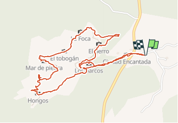

Length
3.6 km

Max alt
1424 m

Uphill gradient
53 m
Km-Effort
4.3 km

Min alt
1381 m

Downhill gradient
54 m
Boucle
Yes
Creation date :
2022-06-17 09:25:51.55
Updated on :
2022-06-17 11:22:12.005
1h11
Difficulty : Easy

FREE GPS app for hiking
 SityTrail
IGN / Geographical institutes
SityTrail World
The world is yours!
About
Trail Walking of 3.6 km to be discovered at Castile-La Mancha, Cuenca, Cuenca. This trail is proposed by lablaquiere.
Positioning
Country:
Spain
Region :
Castile-La Mancha
Department/Province :
Cuenca
Municipality :
Cuenca
Location:
Valdecabras
Start:(Dec)
Start:(UTM)
584729 ; 4451147 (30T) N.
Comments
Trails nearby