


sierra segura

lablaquiere
User
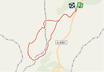

Length
8.9 km

Max alt
1738 m

Uphill gradient
163 m
Km-Effort
11.1 km

Min alt
1674 m

Downhill gradient
163 m
Boucle
Yes
Creation date :
2022-06-16 07:11:24.777
Updated on :
2022-06-16 10:13:45.871
2h09
Difficulty : Very easy

FREE GPS app for hiking
 SityTrail
IGN / Geographical institutes
SityTrail World
The world is yours!
About
Trail Walking of 8.9 km to be discovered at Andalusia, Granada, Huéscar. This trail is proposed by lablaquiere.
Positioning
Country:
Spain
Region :
Andalusia
Department/Province :
Granada
Municipality :
Huéscar
Location:
Unknown
Start:(Dec)
Start:(UTM)
536845 ; 4208426 (30S) N.
Comments
Trails nearby