![](/images/other/stat-length.png)
![Trail Walking Carrara - CR_Francigena_CI_32_Carrare-Avenza_Massa_20220615 - Photo](https://media.geolcdn.com/t/1900/400/738c9f96-ff24-40ad-97f9-3ddd883fa851.jpg&format=pjpeg&maxdim=2)
CR_Francigena_CI_32_Carrare-Avenza_Massa_20220615
patrickdanilo
User
![Length](/images/other/stat-length.png)
Length
13.5 km
![Max alt](https://static1.geolcdn.com/siteimages/upload/files/1508320355ic_sort_altitude_max_24dp.png)
Max alt
200 m
![Uphill gradient](https://static1.geolcdn.com/siteimages/upload/files/1508320355ic_sort_den_pos_24dp.png)
Uphill gradient
299 m
![Km-Effort](/images/other/stat-length.png)
Km-Effort
17.3 km
![Min alt](https://static1.geolcdn.com/siteimages/upload/files/1508320355ic_sort_altitude_min_24dp.png)
Min alt
9 m
![Downhill gradient](https://static1.geolcdn.com/siteimages/upload/files/1508320355ic_sort_den_neg_24dp.png)
Downhill gradient
235 m
![Boucle](https://static1.geolcdn.com/siteimages/upload/files/16400158638029165_repeat_loop_refresh_sync_direction_icon.png)
Boucle
No
Creation date :
2022-06-15 05:55:05.799
Updated on :
2022-08-02 16:33:40.798
![Walking](https://static1.geolcdn.com/sitytour/trail-icons/101.png)
4h00
Difficulty : Medium
![Scan this QR Code to open this trail in the SityTrail application](https://capi.geolives.com/qq0zvz2zws4bq2lad0pu/sitytour/trails/3282920/qr.png?size=200)
FREE GPS app for hiking
About
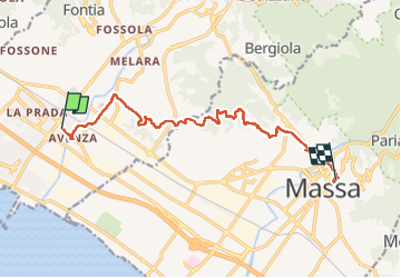
Trail Walking of 13.5 km to be discovered at Tuscany, Massa-Carrara, Carrara. This trail is proposed by patrickdanilo.
Description
Randonnée Marche de 13,5 km à découvrir à Toscane, Massa-Carrara, Carrare. Cette randonnée est proposée par patrickdanilo.
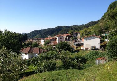
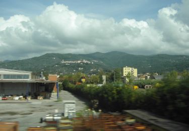
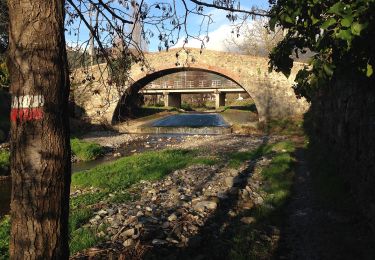
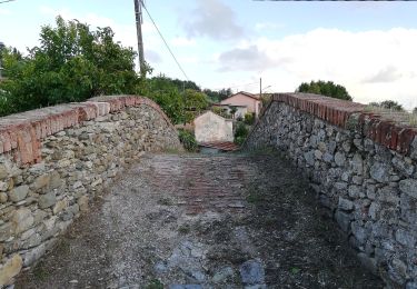
Positioning
Country:
Italy
Region :
Tuscany
Department/Province :
Massa-Carrara
Municipality :
Carrara
Location:
Unknown
Start:(Dec)
Start:(UTM)
584849 ; 4877861 (32T) N.
Comments
Trails nearby
![Trail On foot Luni - Ortonovo - La Foce – M. Bandita – Castelpoggio - Photo](https://media.geolcdn.com/t/375/260/f54f49ea-7930-486a-81a2-7fd03a4c6cbd.jpeg&format=jpg&maxdim=2)
![On foot On foot](https://static1.geolcdn.com/sitytour/trail-icons/100.png)
Ortonovo - La Foce – M. Bandita – Castelpoggio
On foot
Easy
Luni,
Liguria,
La Spezia,
Italy
![](/images/other/stat-length.png)
5.3 km | 9 km-effort
2h 2min
![](https://static1.geolcdn.com/siteimages/upload/files/16400158638029165_repeat_loop_refresh_sync_direction_icon.png)
No
![Trail On foot Carrara - Isola - Nicola Di Ortonovo - Fossone Alto - Fossola - Photo](https://media.geolcdn.com/t/375/260/cc4c9f7c-1ac7-4ea8-b445-d17a67a64b25.jpeg&format=jpg&maxdim=2)
![On foot On foot](https://static1.geolcdn.com/sitytour/trail-icons/100.png)
Isola - Nicola Di Ortonovo - Fossone Alto - Fossola
On foot
Easy
Carrara,
Tuscany,
Massa-Carrara,
Italy
![](/images/other/stat-length.png)
6 km | 10.1 km-effort
2h 18min
![](https://static1.geolcdn.com/siteimages/upload/files/16400158638029165_repeat_loop_refresh_sync_direction_icon.png)
No
![Trail On foot Castelnuovo Magra - Coll. VF - Olmarello - Sarticola – Monticello – C. Bertella - Photo](https://media.geolcdn.com/t/375/260/73740ca8-1c10-41d4-8912-da423521fc9d.jpeg&format=jpg&maxdim=2)
![On foot On foot](https://static1.geolcdn.com/sitytour/trail-icons/100.png)
Coll. VF - Olmarello - Sarticola – Monticello – C. Bertella
On foot
Easy
Castelnuovo Magra,
Liguria,
La Spezia,
Italy
![](/images/other/stat-length.png)
6.1 km | 11.5 km-effort
2h 36min
![](https://static1.geolcdn.com/siteimages/upload/files/16400158638029165_repeat_loop_refresh_sync_direction_icon.png)
No
![Trail On foot Castelnuovo Magra - M.no del Piano - Castelnuovo Magra - Casala - Photo](https://media.geolcdn.com/t/375/260/6db36747-1726-4fff-942f-3ef282794b69.jpeg&format=jpg&maxdim=2)
![On foot On foot](https://static1.geolcdn.com/sitytour/trail-icons/100.png)
M.no del Piano - Castelnuovo Magra - Casala
On foot
Easy
Castelnuovo Magra,
Liguria,
La Spezia,
Italy
![](/images/other/stat-length.png)
4.6 km | 8.1 km-effort
1h 50min
![](https://static1.geolcdn.com/siteimages/upload/files/16400158638029165_repeat_loop_refresh_sync_direction_icon.png)
No
![Trail On foot Carrara - IT-152 - Photo](https://media.geolcdn.com/t/375/260/ext.jpg?maxdim=2&url=https%3A%2F%2Fstatic1.geolcdn.com%2Fsiteimages%2Fupload%2Ffiles%2F1545311037marcheuse_200dpi.jpg)
![On foot On foot](https://static1.geolcdn.com/sitytour/trail-icons/100.png)
![Trail On foot Luni - Ortonovo – La Foce – Fontia - Photo](https://media.geolcdn.com/t/375/260/ext.jpg?maxdim=2&url=https%3A%2F%2Fstatic1.geolcdn.com%2Fsiteimages%2Fupload%2Ffiles%2F1545311037marcheuse_200dpi.jpg)
![On foot On foot](https://static1.geolcdn.com/sitytour/trail-icons/100.png)
Ortonovo – La Foce – Fontia
On foot
Easy
Luni,
Liguria,
La Spezia,
Italy
![](/images/other/stat-length.png)
3.5 km | 5.1 km-effort
1h 10min
![](https://static1.geolcdn.com/siteimages/upload/files/16400158638029165_repeat_loop_refresh_sync_direction_icon.png)
No
![Trail On foot Luni - Isola - Lungo Parmignola - Ortonovo - Photo](https://media.geolcdn.com/t/375/260/ext.jpg?maxdim=2&url=https%3A%2F%2Fstatic1.geolcdn.com%2Fsiteimages%2Fupload%2Ffiles%2F1545311037marcheuse_200dpi.jpg)
![On foot On foot](https://static1.geolcdn.com/sitytour/trail-icons/100.png)
Isola - Lungo Parmignola - Ortonovo
On foot
Easy
Luni,
Liguria,
La Spezia,
Italy
![](/images/other/stat-length.png)
3.3 km | 4.3 km-effort
58min
![](https://static1.geolcdn.com/siteimages/upload/files/16400158638029165_repeat_loop_refresh_sync_direction_icon.png)
No