![](/images/other/stat-length.png)
![Trail Walking Pont de Montvert - Sud Mont Lozère - J3: Le Pont de Montvert-Florac par le Signal du Bougès - Photo](https://media.geolcdn.com/t/1900/400/90965072-0fa2-417d-aa8d-95b604aa87b5.jpg&format=pjpeg&maxdim=2)
J3: Le Pont de Montvert-Florac par le Signal du Bougès
canardDenis
User
![Length](/images/other/stat-length.png)
![Max alt](https://static1.geolcdn.com/siteimages/upload/files/1508320355ic_sort_altitude_max_24dp.png)
![Uphill gradient](https://static1.geolcdn.com/siteimages/upload/files/1508320355ic_sort_den_pos_24dp.png)
![Km-Effort](/images/other/stat-length.png)
![Min alt](https://static1.geolcdn.com/siteimages/upload/files/1508320355ic_sort_altitude_min_24dp.png)
![Downhill gradient](https://static1.geolcdn.com/siteimages/upload/files/1508320355ic_sort_den_neg_24dp.png)
![Boucle](https://static1.geolcdn.com/siteimages/upload/files/16400158638029165_repeat_loop_refresh_sync_direction_icon.png)
![Walking](https://static1.geolcdn.com/sitytour/trail-icons/101.png)
8h21
Difficulty : Very difficult
![Scan this QR Code to open this trail in the SityTrail application](https://capi.geolives.com/qq0zvz2zws4bq2lad0pu/sitytour/trails/3282900/qr.png?size=200)
FREE GPS app for hiking
About
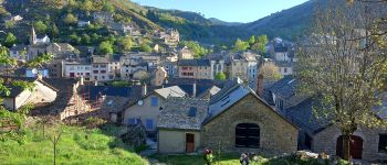
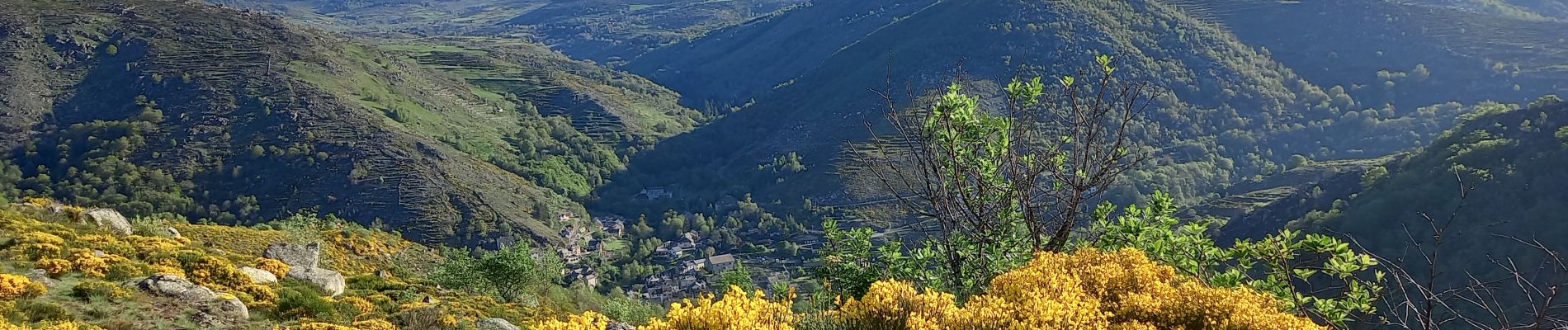
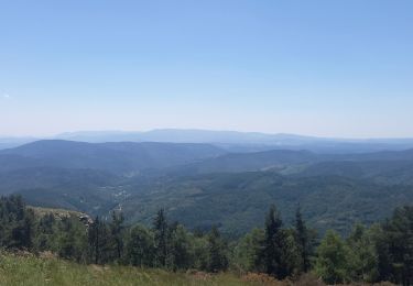
Trail Walking of 25 km to be discovered at Occitania, Lozère, Pont de Montvert - Sud Mont Lozère. This trail is proposed by canardDenis.
Description
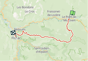
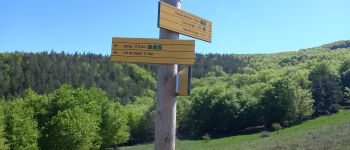
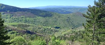
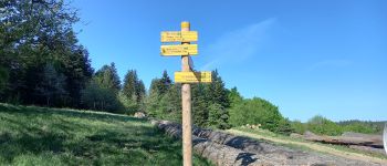
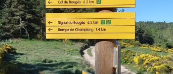
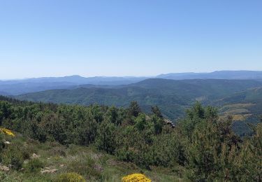
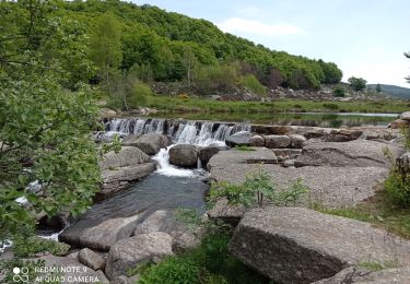
Parmi plusieurs itinéraires proposés, cette troisième étape est un compromis passant par le point haut du Bougès, traversant le parc national des Cévennes puis restant en rive gauche jusqu'à Florac. La randonnée est classée très difficile au vu de sa longueur et des dénivellés cumulés.
Points of interest
Positioning
Comments
Trails nearby
![Trail Walking Pont de Montvert - Sud Mont Lozère - Montagne du Bougès - Photo](https://media.geolcdn.com/t/375/260/0f70d5f6-b995-4149-890f-c1b536613d08.jpg&format=jpg&maxdim=2)
![Walking Walking](https://static1.geolcdn.com/sitytour/trail-icons/101.png)
Walking
![](/images/other/stat-length.png)
![](https://static1.geolcdn.com/siteimages/upload/files/16400158638029165_repeat_loop_refresh_sync_direction_icon.png)
![Trail Walking Pont de Montvert - Sud Mont Lozère - Bédoues saint jean du Gard GR70 gr43 - Photo](https://media.geolcdn.com/t/375/260/c8a87bd6-9939-4680-8373-9b7fd4cfe94c.jpg&format=jpg&maxdim=2)
![Walking Walking](https://static1.geolcdn.com/sitytour/trail-icons/101.png)
Walking
![](/images/other/stat-length.png)
![](https://static1.geolcdn.com/siteimages/upload/files/16400158638029165_repeat_loop_refresh_sync_direction_icon.png)
![Trail Walking Pont de Montvert - Sud Mont Lozère - Stevenson pont de Monvert/ Bedouès - Photo](https://media.geolcdn.com/t/375/260/ecbe7c42-7ae5-463d-8ef8-0e93073f446d.jpg&format=jpg&maxdim=2)
![Walking Walking](https://static1.geolcdn.com/sitytour/trail-icons/101.png)
Walking
![](/images/other/stat-length.png)
![](https://static1.geolcdn.com/siteimages/upload/files/16400158638029165_repeat_loop_refresh_sync_direction_icon.png)
![Trail Walking Pont de Montvert - Sud Mont Lozère - 13-05-2023 E8 Le Pont de Monvers - Bédouès - Photo](https://media.geolcdn.com/t/375/260/e57cdaa9-bdeb-4cef-90ee-76cf38da3fbe.jpg&format=jpg&maxdim=2)
![Walking Walking](https://static1.geolcdn.com/sitytour/trail-icons/101.png)
Walking
![](/images/other/stat-length.png)
![](https://static1.geolcdn.com/siteimages/upload/files/16400158638029165_repeat_loop_refresh_sync_direction_icon.png)
![Trail Walking Pont de Montvert - Sud Mont Lozère - Finiels/ sommet / station du Bleymard en boucle - Photo](https://media.geolcdn.com/t/375/260/f8048304-3a05-4fd0-a0e7-03457722fcee.jpg&format=jpg&maxdim=2)
![Walking Walking](https://static1.geolcdn.com/sitytour/trail-icons/101.png)
Walking
![](/images/other/stat-length.png)
![](https://static1.geolcdn.com/siteimages/upload/files/16400158638029165_repeat_loop_refresh_sync_direction_icon.png)
![Trail Walking Pont de Montvert - Sud Mont Lozère - Signal du Ventalon - Photo](https://media.geolcdn.com/t/375/260/7301b799-eab0-43e1-a503-e72b81bfeb12.jpg&format=jpg&maxdim=2)
![Walking Walking](https://static1.geolcdn.com/sitytour/trail-icons/101.png)
Walking
![](/images/other/stat-length.png)
![](https://static1.geolcdn.com/siteimages/upload/files/16400158638029165_repeat_loop_refresh_sync_direction_icon.png)
![Trail Walking Pont de Montvert - Sud Mont Lozère - J6 Stevenson: Pont de Monvert - Cassagnas - Photo](https://media.geolcdn.com/t/375/260/ext.jpg?maxdim=2&url=https%3A%2F%2Fstatic1.geolcdn.com%2Fsiteimages%2Fupload%2Ffiles%2F1553511878bg_sport_marche.png)
![Walking Walking](https://static1.geolcdn.com/sitytour/trail-icons/101.png)
Walking
![](/images/other/stat-length.png)
![](https://static1.geolcdn.com/siteimages/upload/files/16400158638029165_repeat_loop_refresh_sync_direction_icon.png)
![Trail Walking Pont de Montvert - Sud Mont Lozère - 30 pont Tarn 6 /5/24 - Photo](https://media.geolcdn.com/t/375/260/7d800b0f-50cc-4008-98c4-8c5492592e92.jpg&format=jpg&maxdim=2)
![Walking Walking](https://static1.geolcdn.com/sitytour/trail-icons/101.png)
Walking
![](/images/other/stat-length.png)
![](https://static1.geolcdn.com/siteimages/upload/files/16400158638029165_repeat_loop_refresh_sync_direction_icon.png)
![On foot On foot](https://static1.geolcdn.com/sitytour/trail-icons/100.png)
On foot
![](/images/other/stat-length.png)
![](https://static1.geolcdn.com/siteimages/upload/files/16400158638029165_repeat_loop_refresh_sync_direction_icon.png)