![](/images/other/stat-length.png)
![Trail Walking La Chapelle-Faucher - La Chappelle-Faucher 11km - Photo](https://media.geolcdn.com/t/1900/400/ext.pjpeg?maxdim=2&url=https%3A%2F%2Fstatic1.geolcdn.com%2Fsiteimages%2Fupload%2Ffiles%2F1553511878bg_sport_marche.png)
La Chappelle-Faucher 11km
YV24
User
![Length](/images/other/stat-length.png)
Length
11.3 km
![Max alt](https://static1.geolcdn.com/siteimages/upload/files/1508320355ic_sort_altitude_max_24dp.png)
Max alt
206 m
![Uphill gradient](https://static1.geolcdn.com/siteimages/upload/files/1508320355ic_sort_den_pos_24dp.png)
Uphill gradient
225 m
![Km-Effort](/images/other/stat-length.png)
Km-Effort
14.3 km
![Min alt](https://static1.geolcdn.com/siteimages/upload/files/1508320355ic_sort_altitude_min_24dp.png)
Min alt
119 m
![Downhill gradient](https://static1.geolcdn.com/siteimages/upload/files/1508320355ic_sort_den_neg_24dp.png)
Downhill gradient
227 m
![Boucle](https://static1.geolcdn.com/siteimages/upload/files/16400158638029165_repeat_loop_refresh_sync_direction_icon.png)
Boucle
Yes
Creation date :
2014-12-10 00:00:00.0
Updated on :
2014-12-10 00:00:00.0
![Walking](https://static1.geolcdn.com/sitytour/trail-icons/101.png)
3h06
Difficulty : Easy
![Scan this QR Code to open this trail in the SityTrail application](https://capi.geolives.com/qq0zvz2zws4bq2lad0pu/sitytour/trails/327930/qr.png?size=200)
FREE GPS app for hiking
About
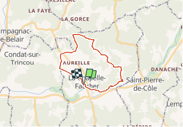
Trail Walking of 11.3 km to be discovered at New Aquitaine, Dordogne, La Chapelle-Faucher. This trail is proposed by YV24.
Description
selon PDIPR carte N°3 Champagnac de Belair. Parcours agréable, bien tracé, varié, peu de bouts de route, bien ombragé et praticable en tout temps. Bons balisage et panneautage.
Positioning
Country:
France
Region :
New Aquitaine
Department/Province :
Dordogne
Municipality :
La Chapelle-Faucher
Location:
Unknown
Start:(Dec)
Start:(UTM)
323859 ; 5026543 (31T) N.
Comments
Trails nearby
![Trail Walking Saint-Pierre-de-Côle - St pierre de Cole - Brantome - Photo](https://media.geolcdn.com/t/375/260/86969db9-e798-4c6b-a1c6-08184f4a2bc3.jpg&format=jpg&maxdim=2)
![Walking Walking](https://static1.geolcdn.com/sitytour/trail-icons/101.png)
St pierre de Cole - Brantome
Walking
Easy
Saint-Pierre-de-Côle,
New Aquitaine,
Dordogne,
France
![](/images/other/stat-length.png)
17.1 km | 22 km-effort
3h 59min
![](https://static1.geolcdn.com/siteimages/upload/files/16400158638029165_repeat_loop_refresh_sync_direction_icon.png)
No
![Trail Walking Champagnac-de-Belair - Boucle de Champagnac de bel air - Photo](https://media.geolcdn.com/t/375/260/ext.jpg?maxdim=2&url=https%3A%2F%2Fstatic1.geolcdn.com%2Fsiteimages%2Fupload%2Ffiles%2F1553511878bg_sport_marche.png)
![Walking Walking](https://static1.geolcdn.com/sitytour/trail-icons/101.png)
Boucle de Champagnac de bel air
Walking
Difficult
Champagnac-de-Belair,
New Aquitaine,
Dordogne,
France
![](/images/other/stat-length.png)
12.7 km | 15.7 km-effort
3h 33min
![](https://static1.geolcdn.com/siteimages/upload/files/16400158638029165_repeat_loop_refresh_sync_direction_icon.png)
Yes
![Trail Walking Saint-Pierre-de-Côle - boucle st pierre de cole - Photo](https://media.geolcdn.com/t/375/260/ext.jpg?maxdim=2&url=https%3A%2F%2Fstatic1.geolcdn.com%2Fsiteimages%2Fupload%2Ffiles%2F1553511878bg_sport_marche.png)
![Walking Walking](https://static1.geolcdn.com/sitytour/trail-icons/101.png)
boucle st pierre de cole
Walking
Medium
Saint-Pierre-de-Côle,
New Aquitaine,
Dordogne,
France
![](/images/other/stat-length.png)
13.4 km | 16.6 km-effort
3h 27min
![](https://static1.geolcdn.com/siteimages/upload/files/16400158638029165_repeat_loop_refresh_sync_direction_icon.png)
Yes
![Trail Walking Saint-Pierre-de-Côle - st pierre brantome - Photo](https://media.geolcdn.com/t/375/260/ext.jpg?maxdim=2&url=https%3A%2F%2Fstatic1.geolcdn.com%2Fsiteimages%2Fupload%2Ffiles%2F1553511878bg_sport_marche.png)
![Walking Walking](https://static1.geolcdn.com/sitytour/trail-icons/101.png)
st pierre brantome
Walking
Difficult
Saint-Pierre-de-Côle,
New Aquitaine,
Dordogne,
France
![](/images/other/stat-length.png)
15.4 km | 19.9 km-effort
2h 45min
![](https://static1.geolcdn.com/siteimages/upload/files/16400158638029165_repeat_loop_refresh_sync_direction_icon.png)
No
![Trail Mountain bike Villars - Mareuil Pauliac Brantôme Pressillac - Photo](https://media.geolcdn.com/t/375/260/ext.jpg?maxdim=2&url=https%3A%2F%2Fstatic1.geolcdn.com%2Fsiteimages%2Fupload%2Ffiles%2F1524743154velo.jpg)
![Mountain bike Mountain bike](https://static1.geolcdn.com/sitytour/trail-icons/202.png)
Mareuil Pauliac Brantôme Pressillac
Mountain bike
Medium
Villars,
New Aquitaine,
Dordogne,
France
![](/images/other/stat-length.png)
109 km | 136 km-effort
8h 23min
![](https://static1.geolcdn.com/siteimages/upload/files/16400158638029165_repeat_loop_refresh_sync_direction_icon.png)
Yes
![Trail Walking Saint-Pierre-de-Côle - St Pierre de Côle Bruzac courte 12km - Photo](https://media.geolcdn.com/t/375/260/ext.jpg?maxdim=2&url=https%3A%2F%2Fstatic1.geolcdn.com%2Fsiteimages%2Fupload%2Ffiles%2F1553511878bg_sport_marche.png)
![Walking Walking](https://static1.geolcdn.com/sitytour/trail-icons/101.png)
St Pierre de Côle Bruzac courte 12km
Walking
Easy
Saint-Pierre-de-Côle,
New Aquitaine,
Dordogne,
France
![](/images/other/stat-length.png)
11.5 km | 14.5 km-effort
3h 10min
![](https://static1.geolcdn.com/siteimages/upload/files/16400158638029165_repeat_loop_refresh_sync_direction_icon.png)
Yes
![Trail Walking Saint-Pierre-de-Côle - St Pierre de Côle Bruzac 15km - Photo](https://media.geolcdn.com/t/375/260/ext.jpg?maxdim=2&url=https%3A%2F%2Fstatic1.geolcdn.com%2Fsiteimages%2Fupload%2Ffiles%2F1553511878bg_sport_marche.png)
![Walking Walking](https://static1.geolcdn.com/sitytour/trail-icons/101.png)
St Pierre de Côle Bruzac 15km
Walking
Easy
Saint-Pierre-de-Côle,
New Aquitaine,
Dordogne,
France
![](/images/other/stat-length.png)
15.1 km | 19 km-effort
4h 6min
![](https://static1.geolcdn.com/siteimages/upload/files/16400158638029165_repeat_loop_refresh_sync_direction_icon.png)
Yes
![Trail Walking Condat-sur-Trincou - Condat-sur-Trincou Dronne Trincou 13km - Photo](https://media.geolcdn.com/t/375/260/ext.jpg?maxdim=2&url=https%3A%2F%2Fstatic1.geolcdn.com%2Fsiteimages%2Fupload%2Ffiles%2F1553511878bg_sport_marche.png)
![Walking Walking](https://static1.geolcdn.com/sitytour/trail-icons/101.png)
Condat-sur-Trincou Dronne Trincou 13km
Walking
Easy
Condat-sur-Trincou,
New Aquitaine,
Dordogne,
France
![](/images/other/stat-length.png)
12.6 km | 15.8 km-effort
3h 26min
![](https://static1.geolcdn.com/siteimages/upload/files/16400158638029165_repeat_loop_refresh_sync_direction_icon.png)
Yes
![Trail Walking Champagnac-de-Belair - Champagnac Belair Drone Trincou - Photo](https://media.geolcdn.com/t/375/260/ext.jpg?maxdim=2&url=https%3A%2F%2Fstatic1.geolcdn.com%2Fsiteimages%2Fupload%2Ffiles%2F1553511878bg_sport_marche.png)
![Walking Walking](https://static1.geolcdn.com/sitytour/trail-icons/101.png)
Champagnac Belair Drone Trincou
Walking
Easy
Champagnac-de-Belair,
New Aquitaine,
Dordogne,
France
![](/images/other/stat-length.png)
13.4 km | 16.7 km-effort
3h 36min
![](https://static1.geolcdn.com/siteimages/upload/files/16400158638029165_repeat_loop_refresh_sync_direction_icon.png)
Yes
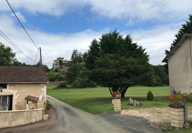
Très très belle randonnée