Trail Walking Villafranca in Lunigiana - CR_Francigena_CF_29_Villafranca-In-Lunigiana_Aulla_20220611 - Photo

CR_Francigena_CF_29_Villafranca-In-Lunigiana_Aulla_20220611

© OpenStreetMap contributors
Length
Length
15.7 km
Max alt
Max alt
259 m
Uphill gradient
Uphill gradient
274 m
Km-Effort
Km-Effort  
19.7 km
Min alt
Min alt
58 m
Downhill gradient
Downhill gradient
379 m
Boucle
Boucle
No
Creation date :
2022-06-11 06:30:31.838
Updated on :
2022-07-25 14:51:42.339

(0 Reviews)

Walking
Walking
4h56
Difficulty : Easy

Scan this QR Code to open this trail in the SityTrail application

FREE GPS app for hiking

Logo SityTrail SityTrail

IGN / Geographical institutes

Download SityTrail from the App Store Download SityTrail from Google Play

Logo SityTrail SityTrail World

The world is yours!

Download SityTrail from the App Store Download SityTrail from Google Play Download SityTrail on Huawei AppGallery

About

Trail Walking of 15.7 km to be discovered at Tuscany, Massa-Carrara, Villafranca in Lunigiana. This trail is proposed by patrickdanilo.

Description

Randonnée Marche de 15,7 km à découvrir à Toscane, Massa-Carrara, Villafranca in Lunigiana. Cette randonnée est proposée par patrickdanilo.

Elevation profile

Photos

Positioning

Country:
Italy
Region :
Tuscany
Department/Province :
Massa-Carrara
Municipality :
Villafranca in Lunigiana
Location:
Unknown
Start:(UTM)
576591 ; 4905744 (32T) N.

Trails nearby

Trail On foot Bagnone - IT-118 - Photo
On foot
PRO

On foot

Easy
Bagnone, Tuscany, Massa-Carrara, Italy
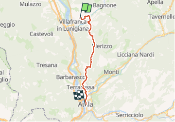
6.8 km | 18.9 km-effort
4h 17min
No
Trail On foot Bagnone - Trekking Lunigiana 7 - Photo
On foot
PRO

On foot

Easy
Bagnone, Tuscany, Massa-Carrara, Italy
9.4 km | 16.1 km-effort
3h 39min
No


Close
My subscriptions