Trail Walking Léoncel - Pierre Chauve - Col de Tourniol - Photo

Pierre Chauve - Col de Tourniol

© OpenStreetMap contributors
Length
Length
6.4 km
Max alt
Max alt
1299 m
Uphill gradient
Uphill gradient
328 m
Km-Effort
Km-Effort  
10.8 km
Min alt
Min alt
1071 m
Downhill gradient
Downhill gradient
329 m
Boucle
Boucle
Yes
Creation date :
2022-06-11 06:41:33.399
Updated on :
2022-06-13 13:44:37.778

(0 Reviews)

Walking
Walking
2h30
Difficulty : Easy

Scan this QR Code to open this trail in the SityTrail application

FREE GPS app for hiking

Logo SityTrail SityTrail

IGN / Geographical institutes

Download SityTrail from the App Store Download SityTrail from Google Play

Logo SityTrail SityTrail World

The world is yours!

Download SityTrail from the App Store Download SityTrail from Google Play Download SityTrail on Huawei AppGallery

About

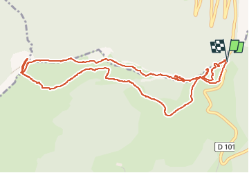
Trail Walking of 6.4 km to be discovered at Auvergne-Rhône-Alpes, Drôme, Léoncel. This trail is proposed by Philindy26.

Description

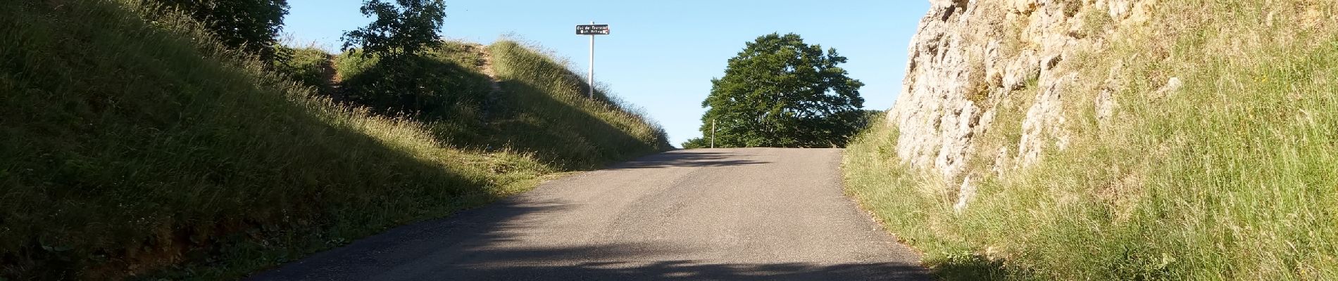
Départ du col de Tourniol (1145 m)...
Géolocalisation (Google Maps) : https://goo.gl/maps/FHx11gvCZsn4Dwjz9

Prendre le sentier qui part tout schuss à l'Ouest du col.
Suivre le sentier jusqu'à un col... Là en prenant à droite (côté bois) vous pouvez vous rendre à la grotte.
Puis au retour au col, montée droit pour atteindre le sommet de Pierre-Chauve (1308 m).
Descente côté Ouest en direction de la Ferrure pour atteindre le pas de Saint-Vincent (1112 m).
Retour sur le col de Tourniol en traversant la Combe Chaude et en passant par la ruine du Ronzier (1199 m).

Elevation profile

Photos

116 photos in total. Please click on a photo to see them all in the gallery.

Positioning

Country:
France
Region :
Auvergne-Rhône-Alpes
Department/Province :
Drôme
Municipality :
Léoncel
Location:
Unknown
Start:(UTM)
672424 ; 4976201 (31T) N.

Trails nearby

Trail Walking Saint-Vincent-la-Commanderie - Pierre Chauve 1308m, les Roches de Treillaras, depuis les Condamines - Photo
Walking
tracegps

Walking

Medium
(2)
Saint-Vincent-la-Commanderie, Auvergne-Rhône-Alpes, Drôme, France
12.7 km | 25 km-effort
6h 30min
Yes
Trail Walking Léoncel - les roches de treillaras - Photo
Walking
olivier26

Walking

Easy
(3)
Léoncel, Auvergne-Rhône-Alpes, Drôme, France
11 km | 16 km-effort
2h 14min
No
Trail Walking Léoncel - Rando Pas du touet -rocher de la drayette - Photo
Walking
jeebeek

Walking

Easy
(3)
Léoncel, Auvergne-Rhône-Alpes, Drôme, France
6.3 km | 8.8 km-effort
2h 11min
Yes
Trail Walking Léoncel - Pierre Chauve depuis le Col de Tourniol - Photo
Walking
McTracy004

Walking

Easy
(3)
Léoncel, Auvergne-Rhône-Alpes, Drôme, France
7.9 km | 12.3 km-effort
2h 52min
Yes
Trail Mountain bike Léoncel - Tête de la Dame - Photo
Mountain bike
Thierryb26

Mountain bike

Medium
(1)
Léoncel, Auvergne-Rhône-Alpes, Drôme, France
27 km | 39 km-effort
2h 35min
Yes
Trail Walking Le Chaffal - Col de la Bataille, Omblèze - Photo
Walking
ajd26

Walking

Difficult
Le Chaffal, Auvergne-Rhône-Alpes, Drôme, France
17.6 km | 32 km-effort
5h 15min
Yes
Trail Walking Barbières - Traversée Barbières Beauregard-Baret - Photo
Walking
GuyVachet

Walking

Very difficult
Barbières, Auvergne-Rhône-Alpes, Drôme, France
17 km | 28 km-effort
7h 9min
No
Trail Walking Le Chaffal - 26 vacherie arches comberoufle - Photo
Walking
randodyssée

Walking

Easy
Le Chaffal, Auvergne-Rhône-Alpes, Drôme, France
7.3 km | 12.1 km-effort
3h 25min
Yes
Trail Walking Peyrus - pont des sarrasins, faucon, piaroux  - Photo
Walking
bymarc26

Walking

Very difficult
Peyrus, Auvergne-Rhône-Alpes, Drôme, France
8.3 km | 14.3 km-effort
3h 2min
Yes


Close
My subscriptions