![](/images/other/stat-length.png)
![Trail Walking Nemours - 3pi-140724 Nemours-RocherVert - Photo](https://media.geolcdn.com/t/1900/400/ext.pjpeg?maxdim=2&url=https%3A%2F%2Fservices.sitytrail.com%2FGeolivesWS%2FDownloadMedia.ashx%3FTrailID%3D327525%26Media%3Dfix__20140724143928.jpg)
3pi-140724 Nemours-RocherVert
randodan
User
![Length](/images/other/stat-length.png)
![Max alt](https://static1.geolcdn.com/siteimages/upload/files/1508320355ic_sort_altitude_max_24dp.png)
![Uphill gradient](https://static1.geolcdn.com/siteimages/upload/files/1508320355ic_sort_den_pos_24dp.png)
![Km-Effort](/images/other/stat-length.png)
![Min alt](https://static1.geolcdn.com/siteimages/upload/files/1508320355ic_sort_altitude_min_24dp.png)
![Downhill gradient](https://static1.geolcdn.com/siteimages/upload/files/1508320355ic_sort_den_neg_24dp.png)
![Boucle](https://static1.geolcdn.com/siteimages/upload/files/16400158638029165_repeat_loop_refresh_sync_direction_icon.png)
![Walking](https://static1.geolcdn.com/sitytour/trail-icons/101.png)
5h00
Difficulty : Medium
![Scan this QR Code to open this trail in the SityTrail application](https://capi.geolives.com/qq0zvz2zws4bq2lad0pu/sitytour/trails/327525/qr.png?size=200)
FREE GPS app for hiking
About
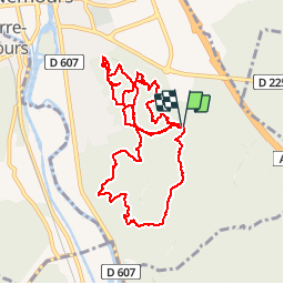
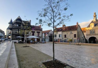
Trail Walking of 11.9 km to be discovered at Ile-de-France, Seine-et-Marne, Nemours. This trail is proposed by randodan.
Description
Jeudi 23 juillet 2014.<br>
Reconnaissance du circuit "Nemours - Rocher Vert, Musée" prévu pour M&R en sept.<br>
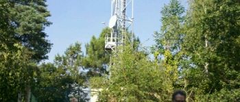
Départ du Parking "Casse-Pot" 9h. Chemin puis sentier du Crot au Loup juqu'au carrefour "du banc". Raté le raccourci vers la butte du pylône, en fait ça devait être le petit sentier vu par JP.<br>
Le retour vers le pylône, versant Nord du Mont d'Olivet : un sentier qu'il aurait fallu forcer en hors piste vers le sommet pour arriver au pylône.<br>
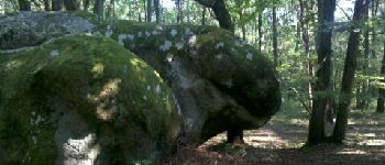
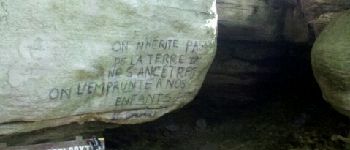
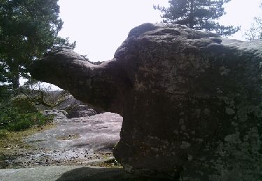
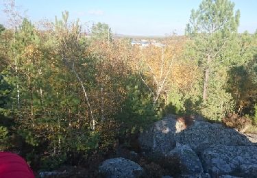
A présent, cap plein Sud vers le point de vue de Chaintréauville et sa table d'orientation, puis la Grotte des Troglodytes (pas vu le Pain de Sucre). Plus le temps de passer par Bethléem, on remonte plein Nord vers le parking en passant par la petite "mer de sable".<br>
12h30, atablés pour le pique-nique.<br>
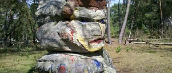
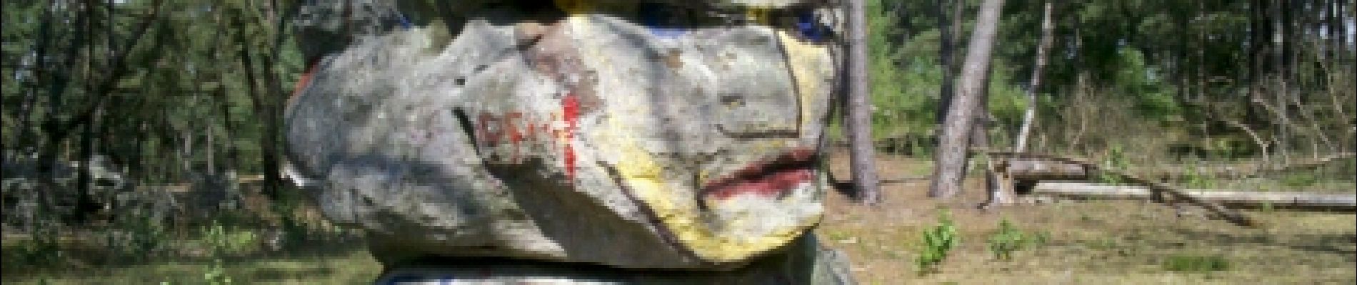
14h, JP et moi repartons pour tester la boucle Nord. Mieroslawski, la Tête d'Indien et les réservoirs en hors piste.<br>
15h30, retour aux voitures. Une journée très chaude et très "moustiques".<br>
Mi JP Da
Positioning
Comments
Trails nearby
![Trail Walking Saint-Pierre-lès-Nemours - Rochers Gréau et Puiselet - Photo](https://media.geolcdn.com/t/375/260/ext.jpg?maxdim=2&url=https%3A%2F%2Fservices.sitytrail.com%2FGeolivesWS%2FDownloadMedia.ashx%3FTrailID%3D262438%26Media%3Dfix__20140401143751.jpg)
![Walking Walking](https://static1.geolcdn.com/sitytour/trail-icons/101.png)
Walking
![](/images/other/stat-length.png)
![](https://static1.geolcdn.com/siteimages/upload/files/16400158638029165_repeat_loop_refresh_sync_direction_icon.png)
![Trail On foot Saint-Pierre-lès-Nemours - Le Mont Blanc de la Commanderie - Photo](https://media.geolcdn.com/t/375/260/44b5b534-5554-427f-a1ac-872604acda7f.jpg&format=jpg&maxdim=2)
![On foot On foot](https://static1.geolcdn.com/sitytour/trail-icons/100.png)
On foot
![](/images/other/stat-length.png)
![](https://static1.geolcdn.com/siteimages/upload/files/16400158638029165_repeat_loop_refresh_sync_direction_icon.png)
![Trail Walking Saint-Pierre-lès-Nemours - De Nemours à Moret + halte resto Bourron Marlotte - Photo](https://media.geolcdn.com/t/375/260/270e70be-f83f-4bbe-bff6-c3c17d849c80.jpg&format=jpg&maxdim=2)
![Walking Walking](https://static1.geolcdn.com/sitytour/trail-icons/101.png)
Walking
![](/images/other/stat-length.png)
![](https://static1.geolcdn.com/siteimages/upload/files/16400158638029165_repeat_loop_refresh_sync_direction_icon.png)
![Trail Walking Nemours - Forêt de Nemours Parking des crottes du loup route de Nemours à Poligny - Photo](https://media.geolcdn.com/t/375/260/ext.jpg?maxdim=2&url=https%3A%2F%2Fstatic1.geolcdn.com%2Fsiteimages%2Fupload%2Ffiles%2F1553511878bg_sport_marche.png)
![Walking Walking](https://static1.geolcdn.com/sitytour/trail-icons/101.png)
Walking
![](/images/other/stat-length.png)
![](https://static1.geolcdn.com/siteimages/upload/files/16400158638029165_repeat_loop_refresh_sync_direction_icon.png)
![Trail Walking Poligny - polynoise 2017 - Photo](https://media.geolcdn.com/t/375/260/ext.jpg?maxdim=2&url=https%3A%2F%2Fstatic1.geolcdn.com%2Fsiteimages%2Fupload%2Ffiles%2F1553511878bg_sport_marche.png)
![Walking Walking](https://static1.geolcdn.com/sitytour/trail-icons/101.png)
Walking
![](/images/other/stat-length.png)
![](https://static1.geolcdn.com/siteimages/upload/files/16400158638029165_repeat_loop_refresh_sync_direction_icon.png)
![Trail Mountain bike Poligny - Poligny 55km - Photo](https://media.geolcdn.com/t/375/260/ext.jpg?maxdim=2&url=https%3A%2F%2Fstatic1.geolcdn.com%2Fsiteimages%2Fupload%2Ffiles%2F1524743154velo.jpg)
![Mountain bike Mountain bike](https://static1.geolcdn.com/sitytour/trail-icons/202.png)
Mountain bike
![](/images/other/stat-length.png)
![](https://static1.geolcdn.com/siteimages/upload/files/16400158638029165_repeat_loop_refresh_sync_direction_icon.png)
![Trail Walking Saint-Pierre-lès-Nemours - Saint Pierre les Nemours - Photo](https://media.geolcdn.com/t/375/260/8cd46912-93f3-4274-87fe-49f7c41f32c6.jpg&format=jpg&maxdim=2)
![Walking Walking](https://static1.geolcdn.com/sitytour/trail-icons/101.png)
Walking
![](/images/other/stat-length.png)
![](https://static1.geolcdn.com/siteimages/upload/files/16400158638029165_repeat_loop_refresh_sync_direction_icon.png)
![Trail Other activity Nemours - 181109 SVG - Photo](https://media.geolcdn.com/t/375/260/ext.jpg?maxdim=2&url=https%3A%2F%2Fservices.sitytrail.com%2FGeolivesWS%2FDownloadMedia.ashx%3FTrailID%3D1078205%26Media%3Dfix__20181109144100.jpg)
![Other activity Other activity](https://static1.geolcdn.com/sitytour/trail-icons/900.png)
Other activity
![](/images/other/stat-length.png)
![](https://static1.geolcdn.com/siteimages/upload/files/16400158638029165_repeat_loop_refresh_sync_direction_icon.png)
![Trail Other activity Nemours - 181109 EnCours - Photo](https://media.geolcdn.com/t/375/260/ext.jpg?maxdim=2&url=https%3A%2F%2Fservices.sitytrail.com%2FGeolivesWS%2FDownloadMedia.ashx%3FTrailID%3D1078201%26Media%3Dfix__20181109144100.jpg)
![Other activity Other activity](https://static1.geolcdn.com/sitytour/trail-icons/900.png)
Other activity
![](/images/other/stat-length.png)
![](https://static1.geolcdn.com/siteimages/upload/files/16400158638029165_repeat_loop_refresh_sync_direction_icon.png)