Trail Nordic walking Saint-André-d'Embrun - plateau de Bouffard Ren ouraux Saint André Embrum - Photo

plateau de Bouffard Ren ouraux Saint André Embrum

 damlou
damlou

User

© OpenStreetMap contributors
Length
Length
6.2 km
Max alt
Max alt
1283 m
Uphill gradient
Uphill gradient
311 m
Km-Effort
Km-Effort  
10.4 km
Min alt
Min alt
983 m
Downhill gradient
Downhill gradient
319 m
Boucle
Boucle
Yes
Creation date :
2022-06-07 07:38:34.43
Updated on :
2022-06-07 10:16:04.606

(0 Reviews)

Nordic walking
Nordic walking
1h49
Difficulty : Medium

Scan this QR Code to open this trail in the SityTrail application

FREE GPS app for hiking

Logo SityTrail SityTrail

IGN / Geographical institutes

Download SityTrail from the App Store Download SityTrail from Google Play

Logo SityTrail SityTrail World

The world is yours!

Download SityTrail from the App Store Download SityTrail from Google Play Download SityTrail on Huawei AppGallery

About

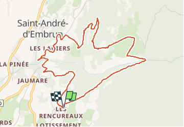
Trail Nordic walking of 6.2 km to be discovered at Provence-Alpes-Côte d'Azur, Hautes-Alpes, Saint-André-d'Embrun. This trail is proposed by damlou.

Description

Bakade en sous -bous 2ontee
1 descente raide

Elevation profile

Positioning

Country:
France
Region :
Provence-Alpes-Côte d'Azur
Department/Province :
Hautes-Alpes
Municipality :
Saint-André-d'Embrun
Location:
Unknown
Start:(UTM)
304537 ; 4938910 (32T) N.

Comments

Please log in to post a review or rate the element


Saint André d'Embrun au dessus des celliers sur livre Guillaine p61. Balade en sous-bois ombragée


Trails nearby

Trail Other activity Crévoux - Ski. Sommet de Meale par Praveyral - Photo
Other activity
CYCLOHC

Other activity

Very easy
(6)
Crévoux, Provence-Alpes-Côte d'Azur, Hautes-Alpes, France
7.4 km | 16.7 km-effort
3h 20min
No
Trail Walking Saint-André-d'Embrun - mont Aurel - Photo
Walking
gibello

Walking

Medium
(1)
Saint-André-d'Embrun, Provence-Alpes-Côte d'Azur, Hautes-Alpes, France
8.2 km | 18.4 km-effort
4h 30min
Yes
Trail Walking Embrun - Lac de l'Hivernet - Photo
Walking
gildascb

Walking

Easy
(1)
Embrun, Provence-Alpes-Côte d'Azur, Hautes-Alpes, France
10.6 km | 21 km-effort
3h 55min
Yes
Trail Walking Embrun - Mont Guillaume-Col de Chanté Perdrix-Lac de l'Hivernet(07-09-16) - Photo
Walking
Dervalmarc

Walking

Difficult
(2)
Embrun, Provence-Alpes-Côte d'Azur, Hautes-Alpes, France
15.4 km | 31 km-effort
7h 4min
Yes
Trail Walking Embrun - Mt Guillaume - Lac de l'Hivernet - Photo
Walking
GUIDE
David25400

Walking

Difficult
Embrun, Provence-Alpes-Côte d'Azur, Hautes-Alpes, France
12.7 km | 28 km-effort
4h 8min
Yes
Trail Walking Embrun - lac de l hivernet - Photo
Walking
gibello

Walking

Easy
(1)
Embrun, Provence-Alpes-Côte d'Azur, Hautes-Alpes, France
9.4 km | 19.5 km-effort
4h 1min
Yes
Trail Walking Saint-André-d'Embrun - Chapelle de Pra-Leydon - Les Croix à partir du vallon de Pra-Mouton - Photo
Walking
gildascb

Walking

Very difficult
Saint-André-d'Embrun, Provence-Alpes-Côte d'Azur, Hautes-Alpes, France
6.8 km | 15.3 km-effort
3h 45min
Yes
Trail Walking Saint-André-d'Embrun - Boucle lac de Siguret et Chapelle Saint Roch - Photo
Walking
gildascb

Walking

Medium
Saint-André-d'Embrun, Provence-Alpes-Côte d'Azur, Hautes-Alpes, France
6.7 km | 9.6 km-effort
2h 14min
Yes
Trail Walking Embrun - Mont Guillaume - Photo
Walking
Marco05

Walking

Difficult
Embrun, Provence-Alpes-Côte d'Azur, Hautes-Alpes, France
12.6 km | 26 km-effort
5h 55min
Yes


Close
My subscriptions