


Aragon 4 juin Goyat to Catalayut

CriCri
User
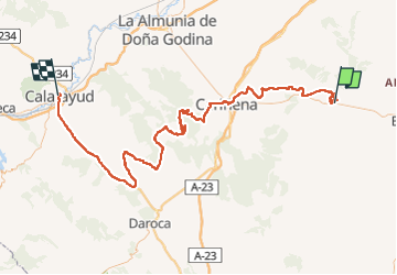

Length
131 km

Max alt
1102 m

Uphill gradient
1958 m
Km-Effort
158 km

Min alt
521 m

Downhill gradient
2149 m
Boucle
No
Creation date :
2022-06-05 11:14:25.125
Updated on :
2022-06-05 15:54:51.777
3h25
Difficulty : Very easy

FREE GPS app for hiking
 SityTrail
IGN / Geographical institutes
SityTrail World
The world is yours!
About
Trail 4x4 of 131 km to be discovered at Aragon, Zaragoza, Fuendetodos. This trail is proposed by CriCri .
Positioning
Country:
Spain
Region :
Aragon
Department/Province :
Zaragoza
Municipality :
Fuendetodos
Location:
Unknown
Start:(Dec)
Start:(UTM)
670957 ; 4578598 (30T) N.
Comments
Trails nearby