![](/images/other/stat-length.png)
![Trail Walking Vleteren - West-Vleteren - Photo](https://media.geolcdn.com/t/1900/400/f1689873-0846-4b61-b2a2-e0d6e0117584.jpg&format=pjpeg&maxdim=2)
West-Vleteren
Geert H.
User
![Length](/images/other/stat-length.png)
Length
18.2 km
![Max alt](https://static1.geolcdn.com/siteimages/upload/files/1508320355ic_sort_altitude_max_24dp.png)
Max alt
28 m
![Uphill gradient](https://static1.geolcdn.com/siteimages/upload/files/1508320355ic_sort_den_pos_24dp.png)
Uphill gradient
79 m
![Km-Effort](/images/other/stat-length.png)
Km-Effort
19.3 km
![Min alt](https://static1.geolcdn.com/siteimages/upload/files/1508320355ic_sort_altitude_min_24dp.png)
Min alt
6 m
![Downhill gradient](https://static1.geolcdn.com/siteimages/upload/files/1508320355ic_sort_den_neg_24dp.png)
Downhill gradient
79 m
![Boucle](https://static1.geolcdn.com/siteimages/upload/files/16400158638029165_repeat_loop_refresh_sync_direction_icon.png)
Boucle
Yes
Creation date :
2022-06-04 08:19:19.159
Updated on :
2022-06-05 08:55:37.059
![Walking](https://static1.geolcdn.com/sitytour/trail-icons/101.png)
3h43
Difficulty : Easy
![Scan this QR Code to open this trail in the SityTrail application](https://capi.geolives.com/qq0zvz2zws4bq2lad0pu/sitytour/trails/3269380/qr.png?size=200)
FREE GPS app for hiking
About
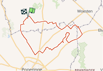
Trail Walking of 18.2 km to be discovered at Flanders, West Flanders, Vleteren. This trail is proposed by Geert H..
Description
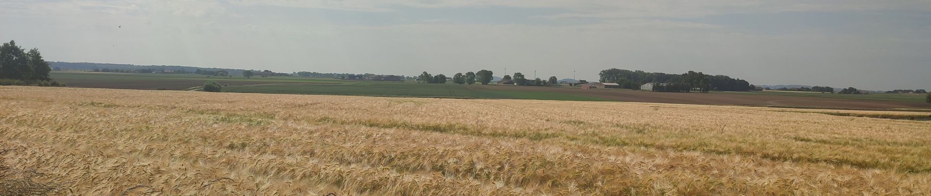
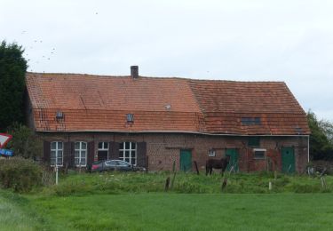
Van de abdij van West-Vleteren richting het Galgenbos. Wegens tijdsgebrek echter het bos laten vallen en langs de Poperingevaart terug gekeerd. Onderweg kom je voorbij aan 2 militaire begraafplaatsen uit WOI nl. Canada Farm Cemetery en Gwalia Cemetery.
Positioning
Country:
Belgium
Region :
Flanders
Department/Province :
West Flanders
Municipality :
Vleteren
Location:
Westvleteren
Start:(Dec)
Start:(UTM)
480457 ; 5638297 (31U) N.
Comments
Trails nearby
![Trail On foot Ypres - Galgebossen - Photo](https://media.geolcdn.com/t/375/260/507b6ec6-4b8d-4ba5-a0c4-d06ce4eec140.jpeg&format=jpg&maxdim=2)
![On foot On foot](https://static1.geolcdn.com/sitytour/trail-icons/100.png)
Galgebossen
On foot
Easy
Ypres,
Flanders,
West Flanders,
Belgium
![](/images/other/stat-length.png)
6.2 km | 7.1 km-effort
1h 37min
![](https://static1.geolcdn.com/siteimages/upload/files/16400158638029165_repeat_loop_refresh_sync_direction_icon.png)
Yes
![Trail On foot Vleteren - Sint-Sixtus wandelroute - Photo](https://media.geolcdn.com/t/375/260/d7a18a7d-eaf1-483e-80b1-b669c1fe0f42.jpeg&format=jpg&maxdim=2)
![On foot On foot](https://static1.geolcdn.com/sitytour/trail-icons/100.png)
Sint-Sixtus wandelroute
On foot
Easy
Vleteren,
Flanders,
West Flanders,
Belgium
![](/images/other/stat-length.png)
7 km | 7.8 km-effort
1h 46min
![](https://static1.geolcdn.com/siteimages/upload/files/16400158638029165_repeat_loop_refresh_sync_direction_icon.png)
Yes
![Trail Walking Alveringem - Door Vlaamse velden en IJzervallei - Photo](https://media.geolcdn.com/t/375/260/63593ed0-27b0-4160-8944-784a7421a9e4.jpg&format=jpg&maxdim=2)
![Walking Walking](https://static1.geolcdn.com/sitytour/trail-icons/101.png)
Door Vlaamse velden en IJzervallei
Walking
Medium
Alveringem,
Flanders,
West Flanders,
Belgium
![](/images/other/stat-length.png)
9.9 km | 10.2 km-effort
2h 48min
![](https://static1.geolcdn.com/siteimages/upload/files/16400158638029165_repeat_loop_refresh_sync_direction_icon.png)
Yes
![Trail Equestrian Vleteren - west vleteren - Photo](https://media.geolcdn.com/t/375/260/ext.jpg?maxdim=2&url=https%3A%2F%2Fstatic1.geolcdn.com%2Fsiteimages%2Fupload%2Ffiles%2F1524743154cheval.jpg)
![Equestrian Equestrian](https://static1.geolcdn.com/sitytour/trail-icons/300.png)
west vleteren
Equestrian
Very easy
Vleteren,
Flanders,
West Flanders,
Belgium
![](/images/other/stat-length.png)
24 km | 26 km-effort
3h 6min
![](https://static1.geolcdn.com/siteimages/upload/files/16400158638029165_repeat_loop_refresh_sync_direction_icon.png)
Yes
![Trail Walking Poperinge - Poperinge-Watou (PVDB) - Photo](https://media.geolcdn.com/t/375/260/ext.jpg?maxdim=2&url=https%3A%2F%2Fstatic1.geolcdn.com%2Fsiteimages%2Fupload%2Ffiles%2F1553511878bg_sport_marche.png)
![Walking Walking](https://static1.geolcdn.com/sitytour/trail-icons/101.png)
Poperinge-Watou (PVDB)
Walking
Very easy
Poperinge,
Flanders,
West Flanders,
Belgium
![](/images/other/stat-length.png)
23 km | 25 km-effort
Unknown
![](https://static1.geolcdn.com/siteimages/upload/files/16400158638029165_repeat_loop_refresh_sync_direction_icon.png)
No
![Trail Walking Vleteren - Sint-Sixtuswandelroute - Photo](https://media.geolcdn.com/t/375/260/ext.jpg?maxdim=2&url=https%3A%2F%2Fstatic1.geolcdn.com%2Fsiteimages%2Fupload%2Ffiles%2F1553511878bg_sport_marche.png)
![Walking Walking](https://static1.geolcdn.com/sitytour/trail-icons/101.png)
Sint-Sixtuswandelroute
Walking
Very easy
(1)
Vleteren,
Flanders,
West Flanders,
Belgium
![](/images/other/stat-length.png)
7.1 km | 7.9 km-effort
Unknown
![](https://static1.geolcdn.com/siteimages/upload/files/16400158638029165_repeat_loop_refresh_sync_direction_icon.png)
Yes
![Trail Walking Vleteren - Brabanthoekwandelroute - Photo](https://media.geolcdn.com/t/375/260/ext.jpg?maxdim=2&url=https%3A%2F%2Fstatic1.geolcdn.com%2Fsiteimages%2Fupload%2Ffiles%2F1553511878bg_sport_marche.png)
![Walking Walking](https://static1.geolcdn.com/sitytour/trail-icons/101.png)
Brabanthoekwandelroute
Walking
Very easy
Vleteren,
Flanders,
West Flanders,
Belgium
![](/images/other/stat-length.png)
6.7 km | 6.9 km-effort
Unknown
![](https://static1.geolcdn.com/siteimages/upload/files/16400158638029165_repeat_loop_refresh_sync_direction_icon.png)
Yes
![Trail Walking Vleteren - Westvleteren - Trappist 3 - Photo](https://media.geolcdn.com/t/375/260/ext.jpg?maxdim=2&url=https%3A%2F%2Fstatic1.geolcdn.com%2Fsiteimages%2Fupload%2Ffiles%2F1553511878bg_sport_marche.png)
![Walking Walking](https://static1.geolcdn.com/sitytour/trail-icons/101.png)
Westvleteren - Trappist 3
Walking
Easy
Vleteren,
Flanders,
West Flanders,
Belgium
![](/images/other/stat-length.png)
26 km | 28 km-effort
4h 30min
![](https://static1.geolcdn.com/siteimages/upload/files/16400158638029165_repeat_loop_refresh_sync_direction_icon.png)
Yes
![Trail Electric bike Vleteren - 2024-09-12_13h54m30_Bierfietsroute Vleteren - Alveringem - Lo-Reninge - 98 (1) - Photo](https://media.geolcdn.com/t/375/260/ext.jpg?maxdim=2&url=https%3A%2F%2Fstatic1.geolcdn.com%2Fsiteimages%2Fupload%2Ffiles%2F1524743154velo.jpg)
![Electric bike Electric bike](https://static1.geolcdn.com/sitytour/trail-icons/205.png)
2024-09-12_13h54m30_Bierfietsroute Vleteren - Alveringem - Lo-Reninge - 98 (1)
Electric bike
Very easy
Vleteren,
Flanders,
West Flanders,
Belgium
![](/images/other/stat-length.png)
34 km | 36 km-effort
Unknown
![](https://static1.geolcdn.com/siteimages/upload/files/16400158638029165_repeat_loop_refresh_sync_direction_icon.png)
Yes