![](/images/other/stat-length.png)
![Trail Walking Brides-les-Bains - Sentier de La Gorge aux pigeons - Photo](https://media.geolcdn.com/t/1900/400/ext.pjpeg?maxdim=2&url=https%3A%2F%2Fstatic1.geolcdn.com%2Fsiteimages%2Fupload%2Ffiles%2F1553511878bg_sport_marche.png)
Sentier de La Gorge aux pigeons
jlrayon
User
![Length](/images/other/stat-length.png)
Length
3.6 km
![Max alt](https://static1.geolcdn.com/siteimages/upload/files/1508320355ic_sort_altitude_max_24dp.png)
Max alt
701 m
![Uphill gradient](https://static1.geolcdn.com/siteimages/upload/files/1508320355ic_sort_den_pos_24dp.png)
Uphill gradient
150 m
![Km-Effort](/images/other/stat-length.png)
Km-Effort
5.6 km
![Min alt](https://static1.geolcdn.com/siteimages/upload/files/1508320355ic_sort_altitude_min_24dp.png)
Min alt
568 m
![Downhill gradient](https://static1.geolcdn.com/siteimages/upload/files/1508320355ic_sort_den_neg_24dp.png)
Downhill gradient
150 m
![Boucle](https://static1.geolcdn.com/siteimages/upload/files/16400158638029165_repeat_loop_refresh_sync_direction_icon.png)
Boucle
Yes
Creation date :
2022-06-01 14:42:51.593
Updated on :
2022-06-01 14:50:01.092
![Walking](https://static1.geolcdn.com/sitytour/trail-icons/101.png)
1h16
Difficulty : Easy
![Scan this QR Code to open this trail in the SityTrail application](https://capi.geolives.com/qq0zvz2zws4bq2lad0pu/sitytour/trails/3266109/qr.png?size=200)
FREE GPS app for hiking
About
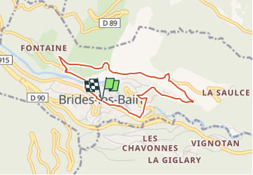
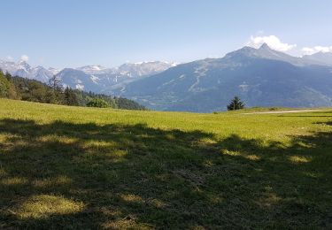
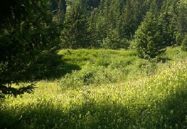
Trail Walking of 3.6 km to be discovered at Auvergne-Rhône-Alpes, Savoy, Brides-les-Bains. This trail is proposed by jlrayon.
Description
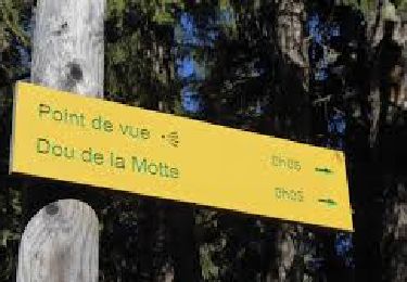
Difficulté : Facile. Aller/retour : 30min à 1h.À partir de l'Office de Tourisme, suivez la rue Aristide Briand, puis descendez sur la droite après les toilettes publiques dans la rue du Chanoine Joly. Traversez le pont Simond et continuez sur la route de Fontaine.
Positioning
Country:
France
Region :
Auvergne-Rhône-Alpes
Department/Province :
Savoy
Municipality :
Brides-les-Bains
Location:
Unknown
Start:(Dec)
Start:(UTM)
309735 ; 5036097 (32T) N.
Comments
Trails nearby
![Trail Walking Feissons-sur-Salins - Rando à Feissons - Photo](https://media.geolcdn.com/t/375/260/063eb2f4-6bf4-4b4a-a131-fc9697177278.jpg&format=jpg&maxdim=2)
![Walking Walking](https://static1.geolcdn.com/sitytour/trail-icons/101.png)
Rando à Feissons
Walking
Easy
Feissons-sur-Salins,
Auvergne-Rhône-Alpes,
Savoy,
France
![](/images/other/stat-length.png)
4.8 km | 7.5 km-effort
1h 33min
![](https://static1.geolcdn.com/siteimages/upload/files/16400158638029165_repeat_loop_refresh_sync_direction_icon.png)
Yes
![Trail Walking Feissons-sur-Salins - Croix de Feissons - Photo](https://media.geolcdn.com/t/375/260/ext.jpg?maxdim=2&url=https%3A%2F%2Fservices.sitytrail.com%2FGeolivesWS%2FDownloadMedia.ashx%3FTrailID%3D958597%26Media%3D3ded4b2c-a6b8-4dd9-b494-9ab426781ec1.jpg)
![Walking Walking](https://static1.geolcdn.com/sitytour/trail-icons/101.png)
Croix de Feissons
Walking
Easy
(1)
Feissons-sur-Salins,
Auvergne-Rhône-Alpes,
Savoy,
France
![](/images/other/stat-length.png)
4.6 km | 7.3 km-effort
1h 0min
![](https://static1.geolcdn.com/siteimages/upload/files/16400158638029165_repeat_loop_refresh_sync_direction_icon.png)
Yes
![Trail Mountain bike Les Allues - Col de la Lune depuis Le Villard - Photo](https://media.geolcdn.com/t/375/260/ext.jpg?maxdim=2&url=https%3A%2F%2Fstatic1.geolcdn.com%2Fsiteimages%2Fupload%2Ffiles%2F1524743154velo.jpg)
![Mountain bike Mountain bike](https://static1.geolcdn.com/sitytour/trail-icons/202.png)
Col de la Lune depuis Le Villard
Mountain bike
Difficult
(1)
Les Allues,
Auvergne-Rhône-Alpes,
Savoy,
France
![](/images/other/stat-length.png)
10.2 km | 18.1 km-effort
4h 0min
![](https://static1.geolcdn.com/siteimages/upload/files/16400158638029165_repeat_loop_refresh_sync_direction_icon.png)
Yes
![Trail Walking Brides-les-Bains - Brides les Bains - Photo](https://media.geolcdn.com/t/375/260/d966be4d-7a5e-462b-885b-72f95b4b7992.jpg&format=jpg&maxdim=2)
![Walking Walking](https://static1.geolcdn.com/sitytour/trail-icons/101.png)
Brides les Bains
Walking
Medium
Brides-les-Bains,
Auvergne-Rhône-Alpes,
Savoy,
France
![](/images/other/stat-length.png)
5.3 km | 8.4 km-effort
1h 25min
![](https://static1.geolcdn.com/siteimages/upload/files/16400158638029165_repeat_loop_refresh_sync_direction_icon.png)
Yes
![Trail Walking Feissons-sur-Salins - Feissons sur salins / Bois du sapey - Photo](https://media.geolcdn.com/t/375/260/372d571c-3325-4051-9cd3-72995a78efc6.jpg&format=jpg&maxdim=2)
![Walking Walking](https://static1.geolcdn.com/sitytour/trail-icons/101.png)
Feissons sur salins / Bois du sapey
Walking
Medium
Feissons-sur-Salins,
Auvergne-Rhône-Alpes,
Savoy,
France
![](/images/other/stat-length.png)
15.2 km | 23 km-effort
4h 2min
![](https://static1.geolcdn.com/siteimages/upload/files/16400158638029165_repeat_loop_refresh_sync_direction_icon.png)
Yes
![On foot On foot](https://static1.geolcdn.com/sitytour/trail-icons/100.png)
Le Dou de la Motte en boucle depuis le Refuge de la Traye
On foot
Very easy
Les Allues,
Auvergne-Rhône-Alpes,
Savoy,
France
![](/images/other/stat-length.png)
4.5 km | 7.6 km-effort
1h 30min
![](https://static1.geolcdn.com/siteimages/upload/files/16400158638029165_repeat_loop_refresh_sync_direction_icon.png)
Yes
![Trail Walking Les Belleville - Beranger La croix de Jean Les refuges Le col de la lune - Photo](https://media.geolcdn.com/t/375/260/c5ad1e17-310b-48d4-b0e4-7e1619b4b8e6.jpg&format=jpg&maxdim=2)
![Walking Walking](https://static1.geolcdn.com/sitytour/trail-icons/101.png)
Beranger La croix de Jean Les refuges Le col de la lune
Walking
Difficult
Les Belleville,
Auvergne-Rhône-Alpes,
Savoy,
France
![](/images/other/stat-length.png)
14.5 km | 25 km-effort
4h 12min
![](https://static1.geolcdn.com/siteimages/upload/files/16400158638029165_repeat_loop_refresh_sync_direction_icon.png)
Yes
![Trail Walking Les Allues - les Allues à Combe Cure - Photo](https://media.geolcdn.com/t/375/260/ext.jpg?maxdim=2&url=https%3A%2F%2Fservices.sitytrail.com%2FGeolivesWS%2FDownloadMedia.ashx%3FTrailID%3D596392%26Media%3Dfix__20160711110233.jpg)
![Walking Walking](https://static1.geolcdn.com/sitytour/trail-icons/101.png)
les Allues à Combe Cure
Walking
Medium
Les Allues,
Auvergne-Rhône-Alpes,
Savoy,
France
![](/images/other/stat-length.png)
9.7 km | 17.8 km-effort
4h 4min
![](https://static1.geolcdn.com/siteimages/upload/files/16400158638029165_repeat_loop_refresh_sync_direction_icon.png)
Yes
![Trail Motorbike Les Belleville - rando menuires - Photo](https://media.geolcdn.com/t/375/260/6a459a38-d7c5-4ace-8cc3-add6d0d07428.jpg&format=jpg&maxdim=2)
![Motorbike Motorbike](https://static1.geolcdn.com/sitytour/trail-icons/402.png)
rando menuires
Motorbike
Difficult
Les Belleville,
Auvergne-Rhône-Alpes,
Savoy,
France
![](/images/other/stat-length.png)
110 km | 180 km-effort
8h 12min
![](https://static1.geolcdn.com/siteimages/upload/files/16400158638029165_repeat_loop_refresh_sync_direction_icon.png)
No