![](/images/other/stat-length.png)
![Trail Walking Chenailler-Mascheix - Gorges de la Ménoire - Photo](https://media.geolcdn.com/t/1900/400/ext.pjpeg?maxdim=2&url=https%3A%2F%2Fservices.sitytrail.com%2FGeolivesWS%2FDownloadMedia.ashx%3FTrailID%3D326293%26Media%3Dfix__20140618182131.jpg)
Gorges de la Ménoire
sdroneau
User
![Length](/images/other/stat-length.png)
Length
9.3 km
![Max alt](https://static1.geolcdn.com/siteimages/upload/files/1508320355ic_sort_altitude_max_24dp.png)
Max alt
521 m
![Uphill gradient](https://static1.geolcdn.com/siteimages/upload/files/1508320355ic_sort_den_pos_24dp.png)
Uphill gradient
290 m
![Km-Effort](/images/other/stat-length.png)
Km-Effort
13.1 km
![Min alt](https://static1.geolcdn.com/siteimages/upload/files/1508320355ic_sort_altitude_min_24dp.png)
Min alt
321 m
![Downhill gradient](https://static1.geolcdn.com/siteimages/upload/files/1508320355ic_sort_den_neg_24dp.png)
Downhill gradient
286 m
![Boucle](https://static1.geolcdn.com/siteimages/upload/files/16400158638029165_repeat_loop_refresh_sync_direction_icon.png)
Boucle
Yes
Creation date :
2014-12-10 00:00:00.0
Updated on :
2014-12-10 00:00:00.0
![Walking](https://static1.geolcdn.com/sitytour/trail-icons/101.png)
2h45
Difficulty : Medium
![Scan this QR Code to open this trail in the SityTrail application](https://capi.geolives.com/qq0zvz2zws4bq2lad0pu/sitytour/trails/326293/qr.png?size=200)
FREE GPS app for hiking
About
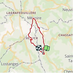
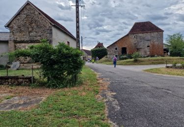
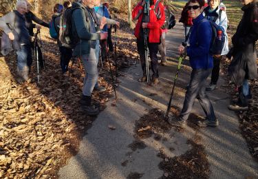
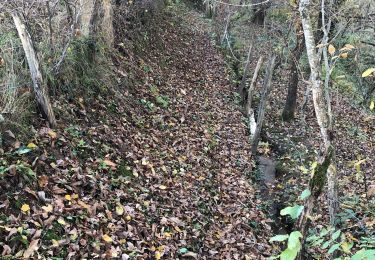
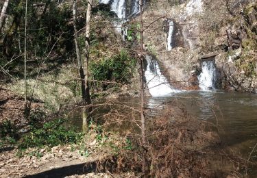
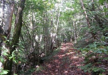
Trail Walking of 9.3 km to be discovered at New Aquitaine, Corrèze, Chenailler-Mascheix. This trail is proposed by sdroneau.
Description
Balade au départ de l’église de Mascheix. Après la descente vers la Ménoire, une montée assez difficile d'1.5 km vous attend. Le reste du parcours est assez facile.
Positioning
Country:
France
Region :
New Aquitaine
Department/Province :
Corrèze
Municipality :
Chenailler-Mascheix
Location:
Unknown
Start:(Dec)
Start:(UTM)
405863 ; 4991362 (31T) N.
Comments
Trails nearby
![Trail Walking Beaulieu-sur-Dordogne - Fred BC Brivezac - Photo](https://media.geolcdn.com/t/375/260/9c977315-9e18-4282-9a28-77b8b1aa27d9.jpg&format=jpg&maxdim=2)
![Walking Walking](https://static1.geolcdn.com/sitytour/trail-icons/101.png)
Fred BC Brivezac
Walking
Difficult
Beaulieu-sur-Dordogne,
New Aquitaine,
Corrèze,
France
![](/images/other/stat-length.png)
9.7 km | 14.8 km-effort
3h 47min
![](https://static1.geolcdn.com/siteimages/upload/files/16400158638029165_repeat_loop_refresh_sync_direction_icon.png)
Yes
![Trail Mountain bike Lostanges - SityTrail - 2034969 - monts-et-vallees-de-lostanges-variante - Photo](https://media.geolcdn.com/t/375/260/ext.jpg?maxdim=2&url=https%3A%2F%2Fstatic1.geolcdn.com%2Fsiteimages%2Fupload%2Ffiles%2F1524743154velo.jpg)
![Mountain bike Mountain bike](https://static1.geolcdn.com/sitytour/trail-icons/202.png)
SityTrail - 2034969 - monts-et-vallees-de-lostanges-variante
Mountain bike
Difficult
(1)
Lostanges,
New Aquitaine,
Corrèze,
France
![](/images/other/stat-length.png)
23 km | 34 km-effort
2h 22min
![](https://static1.geolcdn.com/siteimages/upload/files/16400158638029165_repeat_loop_refresh_sync_direction_icon.png)
Yes
![Trail Mountain bike Chenailler-Mascheix - Roche de Vic depuis Mascheix - Photo](https://media.geolcdn.com/t/375/260/ext.jpg?maxdim=2&url=https%3A%2F%2Fstatic1.geolcdn.com%2Fsiteimages%2Fupload%2Ffiles%2F1524743154velo.jpg)
![Mountain bike Mountain bike](https://static1.geolcdn.com/sitytour/trail-icons/202.png)
Roche de Vic depuis Mascheix
Mountain bike
Easy
(1)
Chenailler-Mascheix,
New Aquitaine,
Corrèze,
France
![](/images/other/stat-length.png)
13.2 km | 17.5 km-effort
1h 8min
![](https://static1.geolcdn.com/siteimages/upload/files/16400158638029165_repeat_loop_refresh_sync_direction_icon.png)
Yes
![Trail Walking Lostanges - Lostanges - Photo](https://media.geolcdn.com/t/375/260/5b875a5f-59f0-429c-b2e1-4616cf8385da.jpg&format=jpg&maxdim=2)
![Walking Walking](https://static1.geolcdn.com/sitytour/trail-icons/101.png)
Lostanges
Walking
Medium
Lostanges,
New Aquitaine,
Corrèze,
France
![](/images/other/stat-length.png)
13.9 km | 21 km-effort
4h 8min
![](https://static1.geolcdn.com/siteimages/upload/files/16400158638029165_repeat_loop_refresh_sync_direction_icon.png)
Yes
![Trail Walking Puy-d'Arnac - puy d'arnac - Photo](https://media.geolcdn.com/t/375/260/5f40bf7e-14f9-4940-8b51-cac111d153b6.jpg&format=jpg&maxdim=2)
![Walking Walking](https://static1.geolcdn.com/sitytour/trail-icons/101.png)
puy d'arnac
Walking
Difficult
Puy-d'Arnac,
New Aquitaine,
Corrèze,
France
![](/images/other/stat-length.png)
10.3 km | 14.1 km-effort
3h 12min
![](https://static1.geolcdn.com/siteimages/upload/files/16400158638029165_repeat_loop_refresh_sync_direction_icon.png)
No
![Trail Walking Ménoire - menoir 2 - Photo](https://media.geolcdn.com/t/375/260/3eec4932-8ad6-49f8-89d5-a2c1696554cb.jpg&format=jpg&maxdim=2)
![Walking Walking](https://static1.geolcdn.com/sitytour/trail-icons/101.png)
menoir 2
Walking
Difficult
Ménoire,
New Aquitaine,
Corrèze,
France
![](/images/other/stat-length.png)
11.3 km | 14.8 km-effort
3h 18min
![](https://static1.geolcdn.com/siteimages/upload/files/16400158638029165_repeat_loop_refresh_sync_direction_icon.png)
Yes
![Trail Walking Chenailler-Mascheix - Circuit Des Serpentines à Chenailler-Mascheix - Photo](https://media.geolcdn.com/t/375/260/16e86fa7-9726-47dd-8406-401ff5d08439.jpg&format=jpg&maxdim=2)
![Walking Walking](https://static1.geolcdn.com/sitytour/trail-icons/101.png)
Circuit Des Serpentines à Chenailler-Mascheix
Walking
Medium
Chenailler-Mascheix,
New Aquitaine,
Corrèze,
France
![](/images/other/stat-length.png)
10.2 km | 14.6 km-effort
2h 6min
![](https://static1.geolcdn.com/siteimages/upload/files/16400158638029165_repeat_loop_refresh_sync_direction_icon.png)
Yes
![Trail Walking Chenailler-Mascheix - gorges de mémoire et cascade gourlastine - Photo](https://media.geolcdn.com/t/375/260/a8056284-18ef-43b8-8329-b3cae7264059.jpg&format=jpg&maxdim=2)
![Walking Walking](https://static1.geolcdn.com/sitytour/trail-icons/101.png)
gorges de mémoire et cascade gourlastine
Walking
Difficult
Chenailler-Mascheix,
New Aquitaine,
Corrèze,
France
![](/images/other/stat-length.png)
10.6 km | 15 km-effort
4h 0min
![](https://static1.geolcdn.com/siteimages/upload/files/16400158638029165_repeat_loop_refresh_sync_direction_icon.png)
No
![Trail Mountain bike Lostanges - Monts et vallées de Lostanges2 - Photo](https://media.geolcdn.com/t/375/260/ext.jpg?maxdim=2&url=https%3A%2F%2Fservices.sitytrail.com%2FGeolivesWS%2FDownloadMedia.ashx%3FTrailID%3D1010208%26Media%3Dfix__20131006115732.jpg)
![Mountain bike Mountain bike](https://static1.geolcdn.com/sitytour/trail-icons/202.png)
Monts et vallées de Lostanges2
Mountain bike
Difficult
Lostanges,
New Aquitaine,
Corrèze,
France
![](/images/other/stat-length.png)
14.1 km | 21 km-effort
4h 0min
![](https://static1.geolcdn.com/siteimages/upload/files/16400158638029165_repeat_loop_refresh_sync_direction_icon.png)
Yes