![](/images/other/stat-length.png)
![Trail Walking Sainte-Hermine - sainte Hermine -bois de e - Photo](https://media.geolcdn.com/t/1900/400/ext.pjpeg?maxdim=2&url=https%3A%2F%2Fstatic1.geolcdn.com%2Fsiteimages%2Fupload%2Ffiles%2F1553511878bg_sport_marche.png)
sainte Hermine -bois de e
RayFab
User
![Length](/images/other/stat-length.png)
Length
10.7 km
![Max alt](https://static1.geolcdn.com/siteimages/upload/files/1508320355ic_sort_altitude_max_24dp.png)
Max alt
85 m
![Uphill gradient](https://static1.geolcdn.com/siteimages/upload/files/1508320355ic_sort_den_pos_24dp.png)
Uphill gradient
111 m
![Km-Effort](/images/other/stat-length.png)
Km-Effort
12.2 km
![Min alt](https://static1.geolcdn.com/siteimages/upload/files/1508320355ic_sort_altitude_min_24dp.png)
Min alt
28 m
![Downhill gradient](https://static1.geolcdn.com/siteimages/upload/files/1508320355ic_sort_den_neg_24dp.png)
Downhill gradient
111 m
![Boucle](https://static1.geolcdn.com/siteimages/upload/files/16400158638029165_repeat_loop_refresh_sync_direction_icon.png)
Boucle
Yes
Creation date :
2022-05-29 13:06:25.034
Updated on :
2022-05-29 16:02:15.641
![Walking](https://static1.geolcdn.com/sitytour/trail-icons/101.png)
2h46
Difficulty : Very easy
![Scan this QR Code to open this trail in the SityTrail application](https://capi.geolives.com/qq0zvz2zws4bq2lad0pu/sitytour/trails/3262347/qr.png?size=200)
FREE GPS app for hiking
About
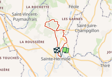
Trail Walking of 10.7 km to be discovered at Pays de la Loire, Vendée, Sainte-Hermine. This trail is proposed by RayFab.
Description
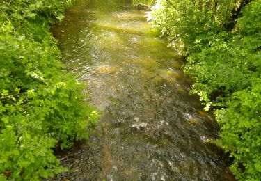
balade dans le bois, hors période estivale mettre des bottes car certains passages très humide, quelques tronçons avec ronces et hautes herbes. sinon, beau parcours
Positioning
Country:
France
Region :
Pays de la Loire
Department/Province :
Vendée
Municipality :
Sainte-Hermine
Location:
Unknown
Start:(Dec)
Start:(UTM)
649157 ; 5157727 (30T) N.
Comments
Trails nearby
![Trail Walking Thiré - thire - Photo](https://media.geolcdn.com/t/375/260/64fe7aef-adc9-4cea-9538-4f68dc0fb7a8.jpg&format=jpg&maxdim=2)
![Walking Walking](https://static1.geolcdn.com/sitytour/trail-icons/101.png)
![Trail Walking Sainte-Hermine - sainte Hermine - la rehorte - Photo](https://media.geolcdn.com/t/375/260/ext.jpg?maxdim=2&url=https%3A%2F%2Fstatic1.geolcdn.com%2Fsiteimages%2Fupload%2Ffiles%2F1553511878bg_sport_marche.png)
![Walking Walking](https://static1.geolcdn.com/sitytour/trail-icons/101.png)
sainte Hermine - la rehorte
Walking
Very easy
(2)
Sainte-Hermine,
Pays de la Loire,
Vendée,
France
![](/images/other/stat-length.png)
14.6 km | 16.9 km-effort
3h 50min
![](https://static1.geolcdn.com/siteimages/upload/files/16400158638029165_repeat_loop_refresh_sync_direction_icon.png)
Yes
![Trail Walking Sainte-Hermine - rando sur le chemin des sages - Photo](https://media.geolcdn.com/t/375/260/f7a99b87-6fbe-4929-ae57-043edd038b7f.jpg&format=jpg&maxdim=2)
![Walking Walking](https://static1.geolcdn.com/sitytour/trail-icons/101.png)
rando sur le chemin des sages
Walking
Very easy
(1)
Sainte-Hermine,
Pays de la Loire,
Vendée,
France
![](/images/other/stat-length.png)
6.9 km | 7.7 km-effort
1h 30min
![](https://static1.geolcdn.com/siteimages/upload/files/16400158638029165_repeat_loop_refresh_sync_direction_icon.png)
Yes
![Trail Walking La Réorthe - Ma Réorthon 2017 - Photo](https://media.geolcdn.com/t/375/260/ext.jpg?maxdim=2&url=https%3A%2F%2Fstatic1.geolcdn.com%2Fsiteimages%2Fupload%2Ffiles%2F1553511878bg_sport_marche.png)
![Walking Walking](https://static1.geolcdn.com/sitytour/trail-icons/101.png)
Ma Réorthon 2017
Walking
Medium
La Réorthe,
Pays de la Loire,
Vendée,
France
![](/images/other/stat-length.png)
25 km | 30 km-effort
6h 25min
![](https://static1.geolcdn.com/siteimages/upload/files/16400158638029165_repeat_loop_refresh_sync_direction_icon.png)
Yes
![Trail Walking Bournezeau - St-Vi cent Puymaufrais - Photo](https://media.geolcdn.com/t/375/260/ext.jpg?maxdim=2&url=https%3A%2F%2Fstatic1.geolcdn.com%2Fsiteimages%2Fupload%2Ffiles%2F1553511878bg_sport_marche.png)
![Walking Walking](https://static1.geolcdn.com/sitytour/trail-icons/101.png)
St-Vi cent Puymaufrais
Walking
Very easy
Bournezeau,
Pays de la Loire,
Vendée,
France
![](/images/other/stat-length.png)
9.8 km | 12 km-effort
2h 37min
![](https://static1.geolcdn.com/siteimages/upload/files/16400158638029165_repeat_loop_refresh_sync_direction_icon.png)
Yes
![Trail Walking Saint-Juire-Champgillon - St Juire - Champgillon (3) - Photo](https://media.geolcdn.com/t/375/260/ext.jpg?maxdim=2&url=https%3A%2F%2Fstatic1.geolcdn.com%2Fsiteimages%2Fupload%2Ffiles%2F1553511878bg_sport_marche.png)
![Walking Walking](https://static1.geolcdn.com/sitytour/trail-icons/101.png)
St Juire - Champgillon (3)
Walking
Easy
Saint-Juire-Champgillon,
Pays de la Loire,
Vendée,
France
![](/images/other/stat-length.png)
7.3 km | 8.4 km-effort
2h 27min
![](https://static1.geolcdn.com/siteimages/upload/files/16400158638029165_repeat_loop_refresh_sync_direction_icon.png)
Yes
![Trail Walking Saint-Juire-Champgillon - St Juire - Champgillon (2) - Photo](https://media.geolcdn.com/t/375/260/ext.jpg?maxdim=2&url=https%3A%2F%2Fstatic1.geolcdn.com%2Fsiteimages%2Fupload%2Ffiles%2F1553511878bg_sport_marche.png)
![Walking Walking](https://static1.geolcdn.com/sitytour/trail-icons/101.png)
St Juire - Champgillon (2)
Walking
Easy
Saint-Juire-Champgillon,
Pays de la Loire,
Vendée,
France
![](/images/other/stat-length.png)
15.3 km | 17.4 km-effort
2h 27min
![](https://static1.geolcdn.com/siteimages/upload/files/16400158638029165_repeat_loop_refresh_sync_direction_icon.png)
Yes
![Trail Walking Saint-Juire-Champgillon - St Juire - Champgillon - Photo](https://media.geolcdn.com/t/375/260/ext.jpg?maxdim=2&url=https%3A%2F%2Fstatic1.geolcdn.com%2Fsiteimages%2Fupload%2Ffiles%2F1553511878bg_sport_marche.png)
![Walking Walking](https://static1.geolcdn.com/sitytour/trail-icons/101.png)
St Juire - Champgillon
Walking
Easy
Saint-Juire-Champgillon,
Pays de la Loire,
Vendée,
France
![](/images/other/stat-length.png)
10 km | 11.2 km-effort
2h 27min
![](https://static1.geolcdn.com/siteimages/upload/files/16400158638029165_repeat_loop_refresh_sync_direction_icon.png)
Yes
![Trail Walking Bournezeau - St Vincent Puymaufrais - Photo](https://media.geolcdn.com/t/375/260/ext.jpg?maxdim=2&url=https%3A%2F%2Fstatic1.geolcdn.com%2Fsiteimages%2Fupload%2Ffiles%2F1553511878bg_sport_marche.png)
![Walking Walking](https://static1.geolcdn.com/sitytour/trail-icons/101.png)
St Vincent Puymaufrais
Walking
Easy
Bournezeau,
Pays de la Loire,
Vendée,
France
![](/images/other/stat-length.png)
8.6 km | 10.5 km-effort
2h 19min
![](https://static1.geolcdn.com/siteimages/upload/files/16400158638029165_repeat_loop_refresh_sync_direction_icon.png)
Yes