![](/images/other/stat-length.png)
![Trail Walking Saint-Symphorien-de-Lay - St Symphorien de lay, agri rando - Photo](https://media.geolcdn.com/t/1900/400/ad65c851-00cb-4ac7-9236-117ab0c718e4.jpg&format=pjpeg&maxdim=2)
St Symphorien de lay, agri rando
mimi69670
User
![Length](/images/other/stat-length.png)
Length
15.6 km
![Max alt](https://static1.geolcdn.com/siteimages/upload/files/1508320355ic_sort_altitude_max_24dp.png)
Max alt
581 m
![Uphill gradient](https://static1.geolcdn.com/siteimages/upload/files/1508320355ic_sort_den_pos_24dp.png)
Uphill gradient
389 m
![Km-Effort](/images/other/stat-length.png)
Km-Effort
21 km
![Min alt](https://static1.geolcdn.com/siteimages/upload/files/1508320355ic_sort_altitude_min_24dp.png)
Min alt
416 m
![Downhill gradient](https://static1.geolcdn.com/siteimages/upload/files/1508320355ic_sort_den_neg_24dp.png)
Downhill gradient
409 m
![Boucle](https://static1.geolcdn.com/siteimages/upload/files/16400158638029165_repeat_loop_refresh_sync_direction_icon.png)
Boucle
No
Creation date :
2022-05-29 09:28:03.121
Updated on :
2022-05-29 14:42:04.962
![Walking](https://static1.geolcdn.com/sitytour/trail-icons/101.png)
4h06
Difficulty : Easy
![Scan this QR Code to open this trail in the SityTrail application](https://capi.geolives.com/qq0zvz2zws4bq2lad0pu/sitytour/trails/3262173/qr.png?size=200)
FREE GPS app for hiking
About
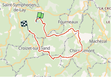
Trail Walking of 15.6 km to be discovered at Auvergne-Rhône-Alpes, Loire, Saint-Symphorien-de-Lay. This trail is proposed by mimi69670.
Description
Départ après st symphorien de Lay. Rando à travers champs, relais dans 3 fermes avec dégustation des produits fermiers
Positioning
Country:
France
Region :
Auvergne-Rhône-Alpes
Department/Province :
Loire
Municipality :
Saint-Symphorien-de-Lay
Location:
Unknown
Start:(Dec)
Start:(UTM)
595535 ; 5087687 (31T) N.
Comments
Trails nearby
![Trail Walking Saint-Symphorien-de-Lay - etang st symphorien de lay - Photo](https://media.geolcdn.com/t/375/260/ext.jpg?maxdim=2&url=https%3A%2F%2Fstatic1.geolcdn.com%2Fsiteimages%2Fupload%2Ffiles%2F1553511878bg_sport_marche.png)
![Walking Walking](https://static1.geolcdn.com/sitytour/trail-icons/101.png)
etang st symphorien de lay
Walking
Difficult
(1)
Saint-Symphorien-de-Lay,
Auvergne-Rhône-Alpes,
Loire,
France
![](/images/other/stat-length.png)
10.6 km | 14.5 km-effort
3h 17min
![](https://static1.geolcdn.com/siteimages/upload/files/16400158638029165_repeat_loop_refresh_sync_direction_icon.png)
Yes
![Trail Walking Saint-Just-la-Pendue - St Just la Pendue, départ à la chapelle - Photo](https://media.geolcdn.com/t/375/260/d9e557db-285e-474a-a80e-c32ca6be6af3.jpg&format=jpg&maxdim=2)
![Walking Walking](https://static1.geolcdn.com/sitytour/trail-icons/101.png)
St Just la Pendue, départ à la chapelle
Walking
Easy
Saint-Just-la-Pendue,
Auvergne-Rhône-Alpes,
Loire,
France
![](/images/other/stat-length.png)
10.1 km | 13.1 km-effort
2h 43min
![](https://static1.geolcdn.com/siteimages/upload/files/16400158638029165_repeat_loop_refresh_sync_direction_icon.png)
Yes
![Walking Walking](https://static1.geolcdn.com/sitytour/trail-icons/101.png)
Saint Symphorien de Lay
Walking
Medium
Saint-Symphorien-de-Lay,
Auvergne-Rhône-Alpes,
Loire,
France
![](/images/other/stat-length.png)
12.1 km | 16.8 km-effort
3h 20min
![](https://static1.geolcdn.com/siteimages/upload/files/16400158638029165_repeat_loop_refresh_sync_direction_icon.png)
Yes
![Walking Walking](https://static1.geolcdn.com/sitytour/trail-icons/101.png)
St Symphorien de Lay
Walking
Medium
Saint-Symphorien-de-Lay,
Auvergne-Rhône-Alpes,
Loire,
France
![](/images/other/stat-length.png)
10.5 km | 14.4 km-effort
3h 3min
![](https://static1.geolcdn.com/siteimages/upload/files/16400158638029165_repeat_loop_refresh_sync_direction_icon.png)
Yes
![Trail Mountain bike Fourneaux - Rando VTT des Crêtes (2014-VTT-50km) - Fourneaux - Photo](https://media.geolcdn.com/t/375/260/ext.jpg?maxdim=2&url=https%3A%2F%2Fservices.sitytrail.com%2FGeolivesWS%2FDownloadMedia.ashx%3FTrailID%3D317960%26Media%3D17396_6.jpg)
![Mountain bike Mountain bike](https://static1.geolcdn.com/sitytour/trail-icons/202.png)
Rando VTT des Crêtes (2014-VTT-50km) - Fourneaux
Mountain bike
Very difficult
Fourneaux,
Auvergne-Rhône-Alpes,
Loire,
France
![](/images/other/stat-length.png)
48 km | 67 km-effort
4h 30min
![](https://static1.geolcdn.com/siteimages/upload/files/16400158638029165_repeat_loop_refresh_sync_direction_icon.png)
Yes
![Trail Mountain bike Saint-Symphorien-de-Lay - VTT au creux des Vallées du Gand de l''Ecoron et du Rhins - Saint-Symphorien-de-Lay - Photo](https://media.geolcdn.com/t/375/260/ext.jpg?maxdim=2&url=https%3A%2F%2Fservices.sitytrail.com%2FGeolivesWS%2FDownloadMedia.ashx%3FTrailID%3D215281%26Media%3D15642_6.jpg)
![Mountain bike Mountain bike](https://static1.geolcdn.com/sitytour/trail-icons/202.png)
VTT au creux des Vallées du Gand de l''Ecoron et du Rhins - Saint-Symphorien-...
Mountain bike
Difficult
Saint-Symphorien-de-Lay,
Auvergne-Rhône-Alpes,
Loire,
France
![](/images/other/stat-length.png)
30 km | 38 km-effort
3h 0min
![](https://static1.geolcdn.com/siteimages/upload/files/16400158638029165_repeat_loop_refresh_sync_direction_icon.png)
Yes
![Trail Running Neaux - La route Napoléon et la Vallée du Gand à VTT - Neaux - Photo](https://media.geolcdn.com/t/375/260/ext.jpg?maxdim=2&url=https%3A%2F%2Fservices.sitytrail.com%2FGeolivesWS%2FDownloadMedia.ashx%3FTrailID%3D215069%26Media%3D15641_6.jpg)
![Running Running](https://static1.geolcdn.com/sitytour/trail-icons/103.png)
La route Napoléon et la Vallée du Gand à VTT - Neaux
Running
Medium
Neaux,
Auvergne-Rhône-Alpes,
Loire,
France
![](/images/other/stat-length.png)
11.7 km | 14.7 km-effort
2h 0min
![](https://static1.geolcdn.com/siteimages/upload/files/16400158638029165_repeat_loop_refresh_sync_direction_icon.png)
Yes
![Trail Mountain bike Neaux - La route Napoléon et la Vallée du Gand à VTT - Neaux - Photo](https://media.geolcdn.com/t/375/260/ext.jpg?maxdim=2&url=https%3A%2F%2Fservices.sitytrail.com%2FGeolivesWS%2FDownloadMedia.ashx%3FTrailID%3D215068%26Media%3D15641_6.jpg)
![Mountain bike Mountain bike](https://static1.geolcdn.com/sitytour/trail-icons/202.png)
La route Napoléon et la Vallée du Gand à VTT - Neaux
Mountain bike
Medium
Neaux,
Auvergne-Rhône-Alpes,
Loire,
France
![](/images/other/stat-length.png)
11.7 km | 14.7 km-effort
1h 15min
![](https://static1.geolcdn.com/siteimages/upload/files/16400158638029165_repeat_loop_refresh_sync_direction_icon.png)
Yes
![Trail Walking Neaux - La route Napoléon et la Vallée du Gand à VTT - Neaux - Photo](https://media.geolcdn.com/t/375/260/ext.jpg?maxdim=2&url=https%3A%2F%2Fservices.sitytrail.com%2FGeolivesWS%2FDownloadMedia.ashx%3FTrailID%3D215067%26Media%3D15641_6.jpg)
![Walking Walking](https://static1.geolcdn.com/sitytour/trail-icons/101.png)
La route Napoléon et la Vallée du Gand à VTT - Neaux
Walking
Medium
Neaux,
Auvergne-Rhône-Alpes,
Loire,
France
![](/images/other/stat-length.png)
11.7 km | 14.7 km-effort
3h 0min
![](https://static1.geolcdn.com/siteimages/upload/files/16400158638029165_repeat_loop_refresh_sync_direction_icon.png)
Yes