Trail Walking Saulzet-le-Froid - 280522 Ferme de la tâche / Lac de Servière  - Photo

280522 Ferme de la tâche / Lac de Servière

© OpenStreetMap contributors
Length
Length
14.5 km
Max alt
Max alt
1426 m
Uphill gradient
Uphill gradient
529 m
Km-Effort
Km-Effort  
21 km
Min alt
Min alt
1113 m
Downhill gradient
Downhill gradient
369 m
Boucle
Boucle
No
Creation date :
2022-05-28 12:15:51.246
Updated on :
2022-05-28 16:19:05.194

(0 Reviews)

Walking
Walking
3h34
Difficulty : Medium

Scan this QR Code to open this trail in the SityTrail application

FREE GPS app for hiking

Logo SityTrail SityTrail

IGN / Geographical institutes

Download SityTrail from the App Store Download SityTrail from Google Play

Logo SityTrail SityTrail World

The world is yours!

Download SityTrail from the App Store Download SityTrail from Google Play Download SityTrail on Huawei AppGallery

About

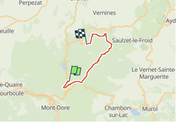
Trail Walking of 14.5 km to be discovered at Auvergne-Rhône-Alpes, Puy-de-Dôme, Saulzet-le-Froid. This trail is proposed by ricou1964.

Description

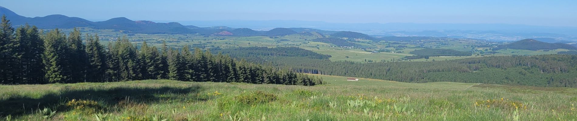
Premier jour de la randonnée avec de superbes paysages.
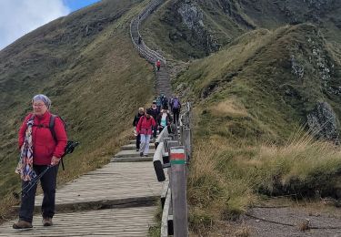
Bivouac et retour demain en direction du lac de Guèry.

Elevation profile

Photos

Positioning

Country:
France
Region :
Auvergne-Rhône-Alpes
Department/Province :
Puy-de-Dôme
Municipality :
Saulzet-le-Froid
Location:
Unknown
Start:(UTM)
486669 ; 5049710 (31T) N.

Trails nearby

Trail Walking Saulzet-le-Froid - Le Puy Baladou - Photo
Walking
Gegetop

Walking

Easy
(4)
Saulzet-le-Froid, Auvergne-Rhône-Alpes, Puy-de-Dôme, France
12.5 km | 17.3 km-effort
2h 54min
Yes
Trail Walking Mont-Dore - Le puy de la tache, le lacs servières et guèry par la cascade du Queureuilh depuis l'Escalidou.  - Photo
Walking
loloetienne

Walking

Difficult
(3)
Mont-Dore, Auvergne-Rhône-Alpes, Puy-de-Dôme, France
34 km | 50 km-effort
10h 16min
Yes
Trail Walking Mont-Dore - Sentier des crêtes Puy de Sancy - Photo
Walking
tracegps

Walking

Difficult
(2)
Mont-Dore, Auvergne-Rhône-Alpes, Puy-de-Dôme, France
26 km | 46 km-effort
9h 0min
Yes
Trail Walking Perpezat - Le lac de Guéry - Photo
Walking
tracegps

Walking

Difficult
(2)
Perpezat, Auvergne-Rhône-Alpes, Puy-de-Dôme, France
15 km | 22 km-effort
4h 0min
Yes
Trail Walking Chambon-sur-Lac - Puy de l'Angle 2740m 11.5.24 - Photo
Walking
GUIDE
fredetpascale

Walking

Medium
Chambon-sur-Lac, Auvergne-Rhône-Alpes, Puy-de-Dôme, France
7.8 km | 15.2 km-effort
2h 30min
Yes
Trail On foot Chambon-sur-Lac - Voissière - Photo
On foot
GUIDE+

On foot

Easy
Chambon-sur-Lac, Auvergne-Rhône-Alpes, Puy-de-Dôme, France
9.4 km | 15 km-effort
3h 24min
Yes
Trail On foot Mont-Dore - Le Mont-Dore / Lac Chambon - Photo
On foot
GUIDE+

On foot

Difficult
Mont-Dore, Auvergne-Rhône-Alpes, Puy-de-Dôme, France
19.4 km | 31 km-effort
7h 6min
No
Trail On foot Mont-Dore - Le Puy Gros - Photo
On foot
GUIDE+

On foot

Easy
(1)
Mont-Dore, Auvergne-Rhône-Alpes, Puy-de-Dôme, France
8.1 km | 13.7 km-effort
3h 6min
Yes
Trail On foot Mont-Dore - Le plateau du Guery - Photo
On foot
GUIDE+

On foot

Easy
Mont-Dore, Auvergne-Rhône-Alpes, Puy-de-Dôme, France
12.2 km | 18.4 km-effort
4h 11min
No


Close
My subscriptions