![](/images/other/stat-length.png)
![Trail Walking Rodès - Gorges de la Guillera - Photo](https://media.geolcdn.com/t/1900/400/87ffb17c-6b51-479b-b62e-81586c0f819f.jpg&format=pjpeg&maxdim=2)
Gorges de la Guillera
Dadou 1
User
![Length](/images/other/stat-length.png)
Length
3.2 km
![Max alt](https://static1.geolcdn.com/siteimages/upload/files/1508320355ic_sort_altitude_max_24dp.png)
Max alt
301 m
![Uphill gradient](https://static1.geolcdn.com/siteimages/upload/files/1508320355ic_sort_den_pos_24dp.png)
Uphill gradient
126 m
![Km-Effort](/images/other/stat-length.png)
Km-Effort
4.9 km
![Min alt](https://static1.geolcdn.com/siteimages/upload/files/1508320355ic_sort_altitude_min_24dp.png)
Min alt
181 m
![Downhill gradient](https://static1.geolcdn.com/siteimages/upload/files/1508320355ic_sort_den_neg_24dp.png)
Downhill gradient
125 m
![Boucle](https://static1.geolcdn.com/siteimages/upload/files/16400158638029165_repeat_loop_refresh_sync_direction_icon.png)
Boucle
Yes
Creation date :
2022-05-26 12:41:26.0
Updated on :
2022-05-26 15:53:37.832
![Walking](https://static1.geolcdn.com/sitytour/trail-icons/101.png)
1h37
Difficulty : Easy
![Scan this QR Code to open this trail in the SityTrail application](https://capi.geolives.com/qq0zvz2zws4bq2lad0pu/sitytour/trails/3257820/qr.png?size=200)
FREE GPS app for hiking
About
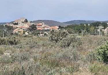
Trail Walking of 3.2 km to be discovered at Occitania, Pyrénées-Orientales, Rodès. This trail is proposed by Dadou 1.
Description
Partir du parking à Rodes
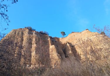
Prendre direction gorges de Guillera
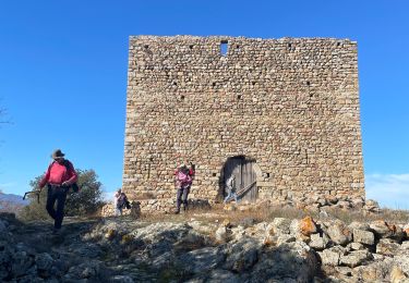
Prendre la direction du château (point bleu)
Et retour de l'autre côté vers le village.
Positioning
Country:
France
Region :
Occitania
Department/Province :
Pyrénées-Orientales
Municipality :
Rodès
Location:
Unknown
Start:(Dec)
Start:(UTM)
463971 ; 4722778 (31T) N.
Comments
Trails nearby
![Trail Walking Ille-sur-Têt - ILLE TÊT 66 - PIC PEDROUS - CASESNOVES - Photo](https://media.geolcdn.com/t/375/260/ext.jpg?maxdim=2&url=https%3A%2F%2Fstatic1.geolcdn.com%2Fsiteimages%2Fupload%2Ffiles%2F1553511878bg_sport_marche.png)
![Walking Walking](https://static1.geolcdn.com/sitytour/trail-icons/101.png)
ILLE TÊT 66 - PIC PEDROUS - CASESNOVES
Walking
Medium
(10)
Ille-sur-Têt,
Occitania,
Pyrénées-Orientales,
France
![](/images/other/stat-length.png)
11 km | 15.3 km-effort
2h 22min
![](https://static1.geolcdn.com/siteimages/upload/files/16400158638029165_repeat_loop_refresh_sync_direction_icon.png)
Yes
![Trail Mountain bike Vinça - parcours ronde de Sahorle 2013 - Photo](https://media.geolcdn.com/t/375/260/ext.jpg?maxdim=2&url=https%3A%2F%2Fstatic1.geolcdn.com%2Fsiteimages%2Fupload%2Ffiles%2F1524743154velo.jpg)
![Mountain bike Mountain bike](https://static1.geolcdn.com/sitytour/trail-icons/202.png)
parcours ronde de Sahorle 2013
Mountain bike
Medium
(1)
Vinça,
Occitania,
Pyrénées-Orientales,
France
![](/images/other/stat-length.png)
17 km | 22 km-effort
1h 27min
![](https://static1.geolcdn.com/siteimages/upload/files/16400158638029165_repeat_loop_refresh_sync_direction_icon.png)
Yes
![Trail Walking Casefabre - Casefabre 66 - Photo](https://media.geolcdn.com/t/375/260/fda5b463-42b5-4e8b-9ebd-458b38a5ec57.jpg&format=jpg&maxdim=2)
![Walking Walking](https://static1.geolcdn.com/sitytour/trail-icons/101.png)
Casefabre 66
Walking
Medium
Casefabre,
Occitania,
Pyrénées-Orientales,
France
![](/images/other/stat-length.png)
10.4 km | 14.8 km-effort
3h 19min
![](https://static1.geolcdn.com/siteimages/upload/files/16400158638029165_repeat_loop_refresh_sync_direction_icon.png)
Yes
![Trail sport Finestret - 20250109 petite boucle depuis Finestret - Photo](https://media.geolcdn.com/t/375/260/e154baa2-7741-43ff-8fd2-a9135305a5c2.jpg&format=jpg&maxdim=2)
20250109 petite boucle depuis Finestret
sport
Very easy
Finestret,
Occitania,
Pyrénées-Orientales,
France
![](/images/other/stat-length.png)
10.1 km | 16.5 km-effort
Unknown
![](https://static1.geolcdn.com/siteimages/upload/files/16400158638029165_repeat_loop_refresh_sync_direction_icon.png)
Yes
![Trail Walking Montalba-le-Château - Montauban le château corral grandes or - Photo](https://media.geolcdn.com/t/375/260/4e0c3970-675f-4ac8-9536-c3e289d07d9a.jpg&format=jpg&maxdim=2)
![Walking Walking](https://static1.geolcdn.com/sitytour/trail-icons/101.png)
Montauban le château corral grandes or
Walking
Difficult
Montalba-le-Château,
Occitania,
Pyrénées-Orientales,
France
![](/images/other/stat-length.png)
12.9 km | 16.3 km-effort
3h 42min
![](https://static1.geolcdn.com/siteimages/upload/files/16400158638029165_repeat_loop_refresh_sync_direction_icon.png)
Yes
![Trail Walking Ille-sur-Têt - puig pedros - Photo](https://media.geolcdn.com/t/375/260/6e0829b7-bca5-48a1-8515-e2b45ee19f4d.jpg&format=jpg&maxdim=2)
![Walking Walking](https://static1.geolcdn.com/sitytour/trail-icons/101.png)
puig pedros
Walking
Medium
Ille-sur-Têt,
Occitania,
Pyrénées-Orientales,
France
![](/images/other/stat-length.png)
11.7 km | 15.6 km-effort
3h 57min
![](https://static1.geolcdn.com/siteimages/upload/files/16400158638029165_repeat_loop_refresh_sync_direction_icon.png)
Yes
![Trail Walking Arboussols - Marcevol - Photo](https://media.geolcdn.com/t/375/260/c36f51d8-a44d-419f-a023-7a6ff9003ad5.jpg&format=jpg&maxdim=2)
![Walking Walking](https://static1.geolcdn.com/sitytour/trail-icons/101.png)
Marcevol
Walking
Very difficult
Arboussols,
Occitania,
Pyrénées-Orientales,
France
![](/images/other/stat-length.png)
15.9 km | 23 km-effort
6h 58min
![](https://static1.geolcdn.com/siteimages/upload/files/16400158638029165_repeat_loop_refresh_sync_direction_icon.png)
Yes
![Trail Walking Tarerach - Tarerach - Photo](https://media.geolcdn.com/t/375/260/ac55caa1-a948-4bf7-87aa-6f2d79de33ca.jpg&format=jpg&maxdim=2)
![Walking Walking](https://static1.geolcdn.com/sitytour/trail-icons/101.png)
Tarerach
Walking
Difficult
Tarerach,
Occitania,
Pyrénées-Orientales,
France
![](/images/other/stat-length.png)
12 km | 16.2 km-effort
3h 19min
![](https://static1.geolcdn.com/siteimages/upload/files/16400158638029165_repeat_loop_refresh_sync_direction_icon.png)
Yes
![Trail Walking Montalba-le-Château - montant a - Photo](https://media.geolcdn.com/t/375/260/bab4a258-ec8b-477d-a8cf-388a6f2cb82a.jpg&format=jpg&maxdim=2)
![Walking Walking](https://static1.geolcdn.com/sitytour/trail-icons/101.png)
montant a
Walking
Difficult
Montalba-le-Château,
Occitania,
Pyrénées-Orientales,
France
![](/images/other/stat-length.png)
11.8 km | 14.7 km-effort
5h 2min
![](https://static1.geolcdn.com/siteimages/upload/files/16400158638029165_repeat_loop_refresh_sync_direction_icon.png)
No