


Oral’s vaerk

boscbilly
User
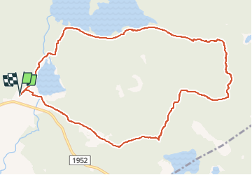

Length
8.4 km

Max alt
369 m

Uphill gradient
191 m
Km-Effort
11 km

Min alt
204 m

Downhill gradient
192 m
Boucle
Yes
Creation date :
2022-05-26 09:26:11.0
Updated on :
2022-05-26 11:55:35.638
2h28
Difficulty : Medium

FREE GPS app for hiking
 SityTrail
IGN / Geographical institutes
SityTrail World
The world is yours!
About
Trail Walking of 8.4 km to be discovered at Innlandet. This trail is proposed by boscbilly.
Positioning
Country:
Norway
Region :
Innlandet
Department/Province :
Unknown
Municipality :
Unknown
Location:
Unknown
Start:(Dec)
Start:(UTM)
658331 ; 6682814 (32V) N.
Comments
Trails nearby