![](/images/other/stat-length.png)
![Trail Walking Ascain - Balcon de la reine, Ihizelaiï - Photo](https://media.geolcdn.com/t/1900/400/ext.pjpeg?maxdim=2&url=https%3A%2F%2Fstatic1.geolcdn.com%2Fsiteimages%2Fupload%2Ffiles%2F1553511878bg_sport_marche.png)
Balcon de la reine, Ihizelaiï
pacha56
User
![Length](/images/other/stat-length.png)
Length
7.6 km
![Max alt](https://static1.geolcdn.com/siteimages/upload/files/1508320355ic_sort_altitude_max_24dp.png)
Max alt
572 m
![Uphill gradient](https://static1.geolcdn.com/siteimages/upload/files/1508320355ic_sort_den_pos_24dp.png)
Uphill gradient
436 m
![Km-Effort](/images/other/stat-length.png)
Km-Effort
13.3 km
![Min alt](https://static1.geolcdn.com/siteimages/upload/files/1508320355ic_sort_altitude_min_24dp.png)
Min alt
130 m
![Downhill gradient](https://static1.geolcdn.com/siteimages/upload/files/1508320355ic_sort_den_neg_24dp.png)
Downhill gradient
427 m
![Boucle](https://static1.geolcdn.com/siteimages/upload/files/16400158638029165_repeat_loop_refresh_sync_direction_icon.png)
Boucle
Yes
Creation date :
2022-05-25 13:20:16.321
Updated on :
2022-05-25 16:42:27.788
![Walking](https://static1.geolcdn.com/sitytour/trail-icons/101.png)
2h51
Difficulty : Easy
![Scan this QR Code to open this trail in the SityTrail application](https://capi.geolives.com/qq0zvz2zws4bq2lad0pu/sitytour/trails/3256633/qr.png?size=200)
FREE GPS app for hiking
About
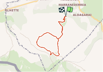
Trail Walking of 7.6 km to be discovered at New Aquitaine, Pyrénées-Atlantiques, Ascain. This trail is proposed by pacha56.
Description
Contreforts de la Rhune, belles vues sur la côte Basque. Au départ du parking de la carrière à Ascain, Passage par le balcon de la reine ,crêtes de l'Ihizelai, boucle par le col des 3 fontaines et redescente.
Positioning
Country:
France
Region :
New Aquitaine
Department/Province :
Pyrénées-Atlantiques
Municipality :
Ascain
Location:
Unknown
Start:(Dec)
Start:(UTM)
611573 ; 4798809 (30T) N.
Comments
Trails nearby
![Trail Walking Ascain - ascain Sare ascain - Photo](https://media.geolcdn.com/t/375/260/2ac8dac9-c2aa-4d90-884c-bc1d060ca05f.jpg&format=jpg&maxdim=2)
![Walking Walking](https://static1.geolcdn.com/sitytour/trail-icons/101.png)
ascain Sare ascain
Walking
Medium
(1)
Ascain,
New Aquitaine,
Pyrénées-Atlantiques,
France
![](/images/other/stat-length.png)
18.8 km | 27 km-effort
4h 39min
![](https://static1.geolcdn.com/siteimages/upload/files/16400158638029165_repeat_loop_refresh_sync_direction_icon.png)
Yes
![Trail Walking Sare - sare - Photo](https://media.geolcdn.com/t/375/260/3b862914-d159-4099-912f-0094f9668d9c.jpg&format=jpg&maxdim=2)
![Walking Walking](https://static1.geolcdn.com/sitytour/trail-icons/101.png)
sare
Walking
Very easy
(1)
Sare,
New Aquitaine,
Pyrénées-Atlantiques,
France
![](/images/other/stat-length.png)
6.6 km | 8.9 km-effort
2h 22min
![](https://static1.geolcdn.com/siteimages/upload/files/16400158638029165_repeat_loop_refresh_sync_direction_icon.png)
No
![Trail Walking Urrugne - Montagne de Ciboure - Trabenea - Photo](https://media.geolcdn.com/t/375/260/ext.jpg?maxdim=2&url=https%3A%2F%2Fservices.sitytrail.com%2FGeolivesWS%2FDownloadMedia.ashx%3FTrailID%3D106416%26Media%3D10905_6.jpg)
![Walking Walking](https://static1.geolcdn.com/sitytour/trail-icons/101.png)
Montagne de Ciboure - Trabenea
Walking
Medium
(2)
Urrugne,
New Aquitaine,
Pyrénées-Atlantiques,
France
![](/images/other/stat-length.png)
8.6 km | 13.3 km-effort
2h 30min
![](https://static1.geolcdn.com/siteimages/upload/files/16400158638029165_repeat_loop_refresh_sync_direction_icon.png)
Yes
![Trail Walking Saint-Pée-sur-Nivelle - Uhartea 22 - Photo](https://media.geolcdn.com/t/375/260/ext.jpg?maxdim=2&url=https%3A%2F%2Fservices.sitytrail.com%2FGeolivesWS%2FDownloadMedia.ashx%3FTrailID%3D103349%26Media%3D5390_3.jpg)
![Walking Walking](https://static1.geolcdn.com/sitytour/trail-icons/101.png)
Uhartea 22
Walking
Very difficult
(1)
Saint-Pée-sur-Nivelle,
New Aquitaine,
Pyrénées-Atlantiques,
France
![](/images/other/stat-length.png)
22 km | 31 km-effort
7h 0min
![](https://static1.geolcdn.com/siteimages/upload/files/16400158638029165_repeat_loop_refresh_sync_direction_icon.png)
Yes
![Walking Walking](https://static1.geolcdn.com/sitytour/trail-icons/101.png)
La Rhune
Walking
Medium
Sare,
New Aquitaine,
Pyrénées-Atlantiques,
France
![](/images/other/stat-length.png)
6.7 km | 9.7 km-effort
2h 18min
![](https://static1.geolcdn.com/siteimages/upload/files/16400158638029165_repeat_loop_refresh_sync_direction_icon.png)
No
![Trail Walking Sare - La rhune par la face EST - Photo](https://media.geolcdn.com/t/375/260/ext.jpg?maxdim=2&url=https%3A%2F%2Fstatic1.geolcdn.com%2Fsiteimages%2Fupload%2Ffiles%2F1553511878bg_sport_marche.png)
![Walking Walking](https://static1.geolcdn.com/sitytour/trail-icons/101.png)
La rhune par la face EST
Walking
Medium
(1)
Sare,
New Aquitaine,
Pyrénées-Atlantiques,
France
![](/images/other/stat-length.png)
13.8 km | 26 km-effort
5h 10min
![](https://static1.geolcdn.com/siteimages/upload/files/16400158638029165_repeat_loop_refresh_sync_direction_icon.png)
Yes
![Trail Walking Sare - la rhune depuis Sare (2) - Photo](https://media.geolcdn.com/t/375/260/ext.jpg?maxdim=2&url=https%3A%2F%2Fstatic1.geolcdn.com%2Fsiteimages%2Fupload%2Ffiles%2F1553511878bg_sport_marche.png)
![Walking Walking](https://static1.geolcdn.com/sitytour/trail-icons/101.png)
la rhune depuis Sare (2)
Walking
Very easy
(4)
Sare,
New Aquitaine,
Pyrénées-Atlantiques,
France
![](/images/other/stat-length.png)
13.9 km | 26 km-effort
4h 0min
![](https://static1.geolcdn.com/siteimages/upload/files/16400158638029165_repeat_loop_refresh_sync_direction_icon.png)
Yes
![Trail Walking Urrugne - rhune - Photo](https://media.geolcdn.com/t/375/260/ext.jpg?maxdim=2&url=https%3A%2F%2Fstatic1.geolcdn.com%2Fsiteimages%2Fupload%2Ffiles%2F1553511878bg_sport_marche.png)
![Walking Walking](https://static1.geolcdn.com/sitytour/trail-icons/101.png)
rhune
Walking
Medium
(1)
Urrugne,
New Aquitaine,
Pyrénées-Atlantiques,
France
![](/images/other/stat-length.png)
11.9 km | 24 km-effort
4h 43min
![](https://static1.geolcdn.com/siteimages/upload/files/16400158638029165_repeat_loop_refresh_sync_direction_icon.png)
Yes
![Trail Mountain bike Urrugne - 64-Olhette-20110417 - Photo](https://media.geolcdn.com/t/375/260/ext.jpg?maxdim=2&url=https%3A%2F%2Fstatic1.geolcdn.com%2Fsiteimages%2Fupload%2Ffiles%2F1524743154velo.jpg)
![Mountain bike Mountain bike](https://static1.geolcdn.com/sitytour/trail-icons/202.png)
64-Olhette-20110417
Mountain bike
Difficult
(2)
Urrugne,
New Aquitaine,
Pyrénées-Atlantiques,
France
![](/images/other/stat-length.png)
33 km | 49 km-effort
3h 30min
![](https://static1.geolcdn.com/siteimages/upload/files/16400158638029165_repeat_loop_refresh_sync_direction_icon.png)
Yes