Trail Walking Waldbillig - 20220525 - Mullertal 11.7 Km - Photo

20220525 - Mullertal 11.7 Km

 pierreh01
pierreh01

User GUIDE

© OpenStreetMap contributors
Length
Length
11.7 km
Max alt
Max alt
373 m
Uphill gradient
Uphill gradient
274 m
Km-Effort
Km-Effort  
15.4 km
Min alt
Min alt
211 m
Downhill gradient
Downhill gradient
275 m
Boucle
Boucle
Yes
Creation date :
2022-05-25 08:05:27.194
Updated on :
2022-05-27 11:43:58.366

(0 Reviews)

Walking
Walking
4h31
Difficulty : Medium

Scan this QR Code to open this trail in the SityTrail application

FREE GPS app for hiking

Logo SityTrail SityTrail

IGN / Geographical institutes

Download SityTrail from the App Store Download SityTrail from Google Play

Logo SityTrail SityTrail World

The world is yours!

Download SityTrail from the App Store Download SityTrail from Google Play Download SityTrail on Huawei AppGallery

About

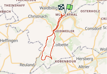
Trail Walking of 11.7 km to be discovered at Unknown, Canton Echternach, Waldbillig. This trail is proposed by pierreh01.

Description

Mercredi 25 mai 2022 : Découverte de la Petite Suisse luxembourgeoise
C'est sous un très beau soleil que nous avons découvert une autre balade dans la région de Müllerthal.
Circuit en boucle, balisé Sentier local - W7, au départ de Müllerthal, légèrement agrandi et avec la boucle sud en sens inverse (le long de l'Ernz noire et le Gluedbaach) en suivant un tracé GPX enregistré, ce qui nous a permis de descendre des escaliers vers l'étang et la cascade au lieu de les monter.

Elevation profile

Photos

42 photos in total. Please click on a photo to see them all in the gallery.

Positioning

Country:
Luxembourg
Region :
Unknown
Department/Province :
Canton Echternach
Municipality :
Waldbillig
Location:
Unknown
Start:(UTM)
306130 ; 5518844 (32U) N.

Trails nearby

Trail Walking Waldbillig - 2024-08-10_15h10m00_Sentier_local_-_W4 - Photo
Walking
GUIDE
mumu.larandonneuse

Walking

Medium
(1)
Waldbillig, Unknown, Canton Echternach, Luxembourg
6.2 km | 7.8 km-effort
1h 45min
Yes
Trail Walking Consdorf - 2023-06-19_09h33m43_Sentier_local_-_C6 - Photo
Walking
GUIDE
mumu.larandonneuse

Walking

Medium
(1)
Consdorf, Unknown, Canton Echternach, Luxembourg
5.8 km | 7.3 km-effort
1h 39min
Yes
Trail Walking Consdorf - 2023-06-13_20h43m48_Sentier_local_-_C2 - Photo
Walking
GUIDE
mumu.larandonneuse

Walking

Easy
(1)
Consdorf, Unknown, Canton Echternach, Luxembourg
4.2 km | 5.5 km-effort
1h 15min
Yes
Trail Walking Consdorf - 2023-06-13_20h03m09_Circuit_auto-pdestre_Consdorf_-_Mullerthal - Photo
Walking
GUIDE
mumu.larandonneuse

Walking

Medium
(2)
Consdorf, Unknown, Canton Echternach, Luxembourg
9 km | 12.3 km-effort
2h 48min
Yes
Trail Walking Berdorf - Berdorf - B2 - Müllerthal - Photo
Walking
GUIDE
mumu.larandonneuse

Walking

Medium
(2)
Berdorf, Unknown, Canton Echternach, Luxembourg
6.7 km | 8.5 km-effort
1h 35min
Yes
Trail Walking Beaufort - 2021-07-05_20h10m00_gpx-file (1) - Photo
Walking
GUIDE
mumu.larandonneuse

Walking

Medium
(1)
Beaufort, Unknown, Canton Echternach, Luxembourg
10.6 km | 13.6 km-effort
3h 5min
Yes
Trail Walking Consdorf - 2023-06-21_17h04m10_Sentier_local_-_C1 (1) - Photo
Walking
GUIDE
mumu.larandonneuse

Walking

Easy
(1)
Consdorf, Unknown, Canton Echternach, Luxembourg
1.9 km | 2.5 km-effort
34min
Yes
Trail Walking Berdorf - 2023-06-03_18h17m36_Sentier_local_-_B8 - Photo
Walking
GUIDE
mumu.larandonneuse

Walking

Medium
(2)
Berdorf, Unknown, Canton Echternach, Luxembourg
11.7 km | 15 km-effort
3h 24min
Yes
Trail Walking Waldbillig - Mullerthal randonnée magnifique - Photo
Walking
Alfredy

Walking

Difficult
(4)
Waldbillig, Unknown, Canton Echternach, Luxembourg
9.3 km | 12.9 km-effort
4h 21min
Yes


Close
My subscriptions