![](/images/other/stat-length.png)
![Trail Walking Plœmeur - ploemeur-mer et campagne - Photo](https://media.geolcdn.com/t/1900/400/ext.pjpeg?maxdim=2&url=https%3A%2F%2Fstatic1.geolcdn.com%2Fsiteimages%2Fupload%2Ffiles%2F1553511878bg_sport_marche.png)
ploemeur-mer et campagne
AHervé56
User
![Length](/images/other/stat-length.png)
Length
11.1 km
![Max alt](https://static1.geolcdn.com/siteimages/upload/files/1508320355ic_sort_altitude_max_24dp.png)
Max alt
42 m
![Uphill gradient](https://static1.geolcdn.com/siteimages/upload/files/1508320355ic_sort_den_pos_24dp.png)
Uphill gradient
73 m
![Km-Effort](/images/other/stat-length.png)
Km-Effort
12.1 km
![Min alt](https://static1.geolcdn.com/siteimages/upload/files/1508320355ic_sort_altitude_min_24dp.png)
Min alt
4 m
![Downhill gradient](https://static1.geolcdn.com/siteimages/upload/files/1508320355ic_sort_den_neg_24dp.png)
Downhill gradient
73 m
![Boucle](https://static1.geolcdn.com/siteimages/upload/files/16400158638029165_repeat_loop_refresh_sync_direction_icon.png)
Boucle
Yes
Creation date :
2022-05-22 13:01:13.329
Updated on :
2022-05-22 16:18:18.847
![Walking](https://static1.geolcdn.com/sitytour/trail-icons/101.png)
2h15
Difficulty : Medium
![Scan this QR Code to open this trail in the SityTrail application](https://capi.geolives.com/qq0zvz2zws4bq2lad0pu/sitytour/trails/3252937/qr.png?size=200)
FREE GPS app for hiking
About
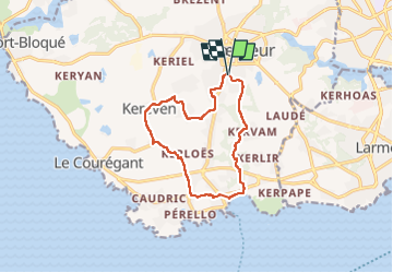
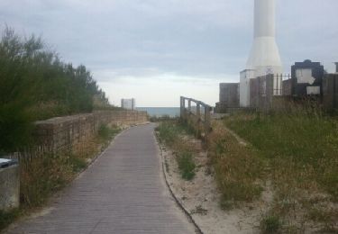
Trail Walking of 11.1 km to be discovered at Brittany, Morbihan, Plœmeur. This trail is proposed by AHervé56.
Description
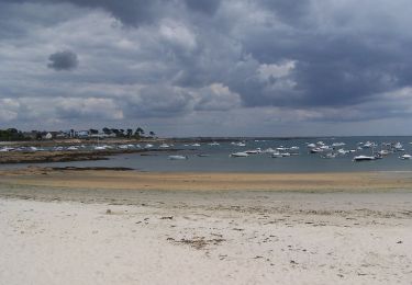
Départ par le chemin de la mer vers l'anse du Stole.
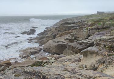
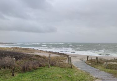
Retour par le chemin du puits, le chemin du fortin (à éviter cependant en période de pluie car il devient vite boueux) et Kerloret
Positioning
Country:
France
Region :
Brittany
Department/Province :
Morbihan
Municipality :
Plœmeur
Location:
Unknown
Start:(Dec)
Start:(UTM)
467718 ; 5286383 (30T) N.
Comments
Trails nearby
![Trail On foot Plœmeur - De la côte bleue aux collines blanches - Photo](https://media.geolcdn.com/t/375/260/b1cbbfe3-b17d-4626-90da-fc66faf0ad01.jpeg&format=jpg&maxdim=2)
![On foot On foot](https://static1.geolcdn.com/sitytour/trail-icons/100.png)
De la côte bleue aux collines blanches
On foot
Easy
Plœmeur,
Brittany,
Morbihan,
France
![](/images/other/stat-length.png)
9.1 km | 10 km-effort
2h 16min
![](https://static1.geolcdn.com/siteimages/upload/files/16400158638029165_repeat_loop_refresh_sync_direction_icon.png)
No
![Trail Walking Plœmeur - PR_56_Ploemeur_AA_01_Circuit3a_Des-Sables_20240413 - Photo](https://media.geolcdn.com/t/375/260/098300ee-8857-4731-b3c5-e3bdc7128025.jpg&format=jpg&maxdim=2)
![Walking Walking](https://static1.geolcdn.com/sitytour/trail-icons/101.png)
PR_56_Ploemeur_AA_01_Circuit3a_Des-Sables_20240413
Walking
Difficult
Plœmeur,
Brittany,
Morbihan,
France
![](/images/other/stat-length.png)
13.6 km | 14.9 km-effort
2h 53min
![](https://static1.geolcdn.com/siteimages/upload/files/16400158638029165_repeat_loop_refresh_sync_direction_icon.png)
Yes
![Trail Walking Larmor-Plage - plage-rade - Photo](https://media.geolcdn.com/t/375/260/ext.jpg?maxdim=2&url=https%3A%2F%2Fstatic1.geolcdn.com%2Fsiteimages%2Fupload%2Ffiles%2F1553511878bg_sport_marche.png)
![Walking Walking](https://static1.geolcdn.com/sitytour/trail-icons/101.png)
plage-rade
Walking
Medium
(1)
Larmor-Plage,
Brittany,
Morbihan,
France
![](/images/other/stat-length.png)
10.4 km | 11.4 km-effort
2h 36min
![](https://static1.geolcdn.com/siteimages/upload/files/16400158638029165_repeat_loop_refresh_sync_direction_icon.png)
No
![Trail Walking Plœmeur - circuit des sables - Photo](https://media.geolcdn.com/t/375/260/9f31c0d5-bc1c-4279-9e36-8c2a982e291d.jpg&format=jpg&maxdim=2)
![Walking Walking](https://static1.geolcdn.com/sitytour/trail-icons/101.png)
circuit des sables
Walking
Medium
Plœmeur,
Brittany,
Morbihan,
France
![](/images/other/stat-length.png)
13.1 km | 14.4 km-effort
3h 23min
![](https://static1.geolcdn.com/siteimages/upload/files/16400158638029165_repeat_loop_refresh_sync_direction_icon.png)
Yes
![Trail Walking Plœmeur - Les rives du Ter - Photo](https://media.geolcdn.com/t/375/260/ab92fa16-d5e9-4f03-b5d2-7ef27a7bc822.jpg&format=jpg&maxdim=2)
![Walking Walking](https://static1.geolcdn.com/sitytour/trail-icons/101.png)
Les rives du Ter
Walking
Easy
Plœmeur,
Brittany,
Morbihan,
France
![](/images/other/stat-length.png)
9.2 km | 10.5 km-effort
1h 34min
![](https://static1.geolcdn.com/siteimages/upload/files/16400158638029165_repeat_loop_refresh_sync_direction_icon.png)
Yes
![Trail Walking Plœmeur - Kerroc'h La pointe du Talud - Photo](https://media.geolcdn.com/t/375/260/b43d6783-ca16-4931-b6c6-8dca7d39be68.jpg&format=jpg&maxdim=2)
![Walking Walking](https://static1.geolcdn.com/sitytour/trail-icons/101.png)
Kerroc'h La pointe du Talud
Walking
Easy
Plœmeur,
Brittany,
Morbihan,
France
![](/images/other/stat-length.png)
4.4 km | 4.8 km-effort
49min
![](https://static1.geolcdn.com/siteimages/upload/files/16400158638029165_repeat_loop_refresh_sync_direction_icon.png)
Yes
![Trail Walking Plœmeur - Saint Jude - Les Kaolins - Fort Bloqué - Photo](https://media.geolcdn.com/t/375/260/31519eb1-c94d-4494-8791-a7c97591c2f0.jpg&format=jpg&maxdim=2)
![Walking Walking](https://static1.geolcdn.com/sitytour/trail-icons/101.png)
Saint Jude - Les Kaolins - Fort Bloqué
Walking
Easy
(1)
Plœmeur,
Brittany,
Morbihan,
France
![](/images/other/stat-length.png)
13.1 km | 14.6 km-effort
2h 21min
![](https://static1.geolcdn.com/siteimages/upload/files/16400158638029165_repeat_loop_refresh_sync_direction_icon.png)
Yes
![Trail Cycle Plœmeur - Chemin de Ploemeur vers la mer - Photo](https://media.geolcdn.com/t/375/260/ext.jpg?maxdim=2&url=https%3A%2F%2Fservices.sitytrail.com%2FGeolivesWS%2FDownloadMedia.ashx%3FTrailID%3D200606%26Media%3D20130625211439.jpeg)
![Cycle Cycle](https://static1.geolcdn.com/sitytour/trail-icons/200.png)
Chemin de Ploemeur vers la mer
Cycle
Easy
(1)
Plœmeur,
Brittany,
Morbihan,
France
![](/images/other/stat-length.png)
3.9 km | 4.4 km-effort
15min
![](https://static1.geolcdn.com/siteimages/upload/files/16400158638029165_repeat_loop_refresh_sync_direction_icon.png)
No
![Trail Walking Plœmeur - 56-4-Plage de Pen Er Malo (Fort Bloqué) - Plage des Kaolins (St. Jude) - Photo](https://media.geolcdn.com/t/375/260/ext.jpg?maxdim=2&url=https%3A%2F%2Fstatic1.geolcdn.com%2Fsiteimages%2Fupload%2Ffiles%2F1553511878bg_sport_marche.png)
![Walking Walking](https://static1.geolcdn.com/sitytour/trail-icons/101.png)
56-4-Plage de Pen Er Malo (Fort Bloqué) - Plage des Kaolins (St. Jude)
Walking
Very easy
(1)
Plœmeur,
Brittany,
Morbihan,
France
![](/images/other/stat-length.png)
6.1 km | 6.6 km-effort
5min
![](https://static1.geolcdn.com/siteimages/upload/files/16400158638029165_repeat_loop_refresh_sync_direction_icon.png)
Yes