![](/images/other/stat-length.png)
![Trail Walking Bénonces - chartreuse de porte - Photo](https://media.geolcdn.com/t/1900/400/ext.pjpeg?maxdim=2&url=https%3A%2F%2Fstatic1.geolcdn.com%2Fsiteimages%2Fupload%2Ffiles%2F1553511878bg_sport_marche.png)
chartreuse de porte
Cartu73
User
![Length](/images/other/stat-length.png)
Length
10.4 km
![Max alt](https://static1.geolcdn.com/siteimages/upload/files/1508320355ic_sort_altitude_max_24dp.png)
Max alt
1015 m
![Uphill gradient](https://static1.geolcdn.com/siteimages/upload/files/1508320355ic_sort_den_pos_24dp.png)
Uphill gradient
315 m
![Km-Effort](/images/other/stat-length.png)
Km-Effort
14.6 km
![Min alt](https://static1.geolcdn.com/siteimages/upload/files/1508320355ic_sort_altitude_min_24dp.png)
Min alt
772 m
![Downhill gradient](https://static1.geolcdn.com/siteimages/upload/files/1508320355ic_sort_den_neg_24dp.png)
Downhill gradient
316 m
![Boucle](https://static1.geolcdn.com/siteimages/upload/files/16400158638029165_repeat_loop_refresh_sync_direction_icon.png)
Boucle
Yes
Creation date :
2022-05-22 09:08:03.073
Updated on :
2022-05-22 15:48:06.27
![Walking](https://static1.geolcdn.com/sitytour/trail-icons/101.png)
3h26
Difficulty : Easy
![Scan this QR Code to open this trail in the SityTrail application](https://capi.geolives.com/qq0zvz2zws4bq2lad0pu/sitytour/trails/3252850/qr.png?size=200)
FREE GPS app for hiking
About
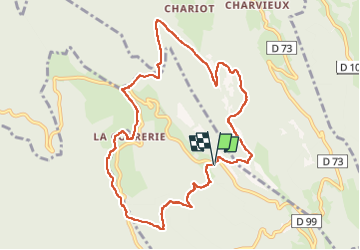
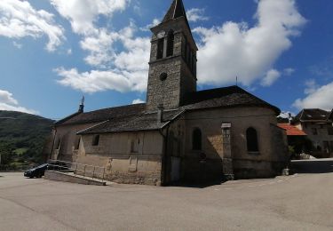
Trail Walking of 10.4 km to be discovered at Auvergne-Rhône-Alpes, Ain, Bénonces. This trail is proposed by Cartu73.
Description
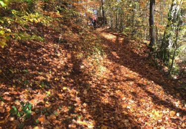
Randonnée sans grande difficulté,essentiellement en sous bois ou forêt (magnifique).
Type de chemin:
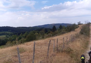
La plupart du temps route forestiere ou chemin bien large.
Chemin plus étroit après la correrie et le temps de remonter vers le col de porte et le parking.
Positioning
Country:
France
Region :
Auvergne-Rhône-Alpes
Department/Province :
Ain
Municipality :
Bénonces
Location:
Unknown
Start:(Dec)
Start:(UTM)
693029 ; 5081333 (31T) N.
Comments
Trails nearby
![Trail Mountain bike Arandas - Arandas-Plomb-Plateau de Suerme - Photo](https://media.geolcdn.com/t/375/260/ext.jpg?maxdim=2&url=https%3A%2F%2Fservices.sitytrail.com%2FGeolivesWS%2FDownloadMedia.ashx%3FTrailID%3D790474%26Media%3Dfix__20170716121750.jpg)
![Mountain bike Mountain bike](https://static1.geolcdn.com/sitytour/trail-icons/202.png)
Arandas-Plomb-Plateau de Suerme
Mountain bike
Difficult
(1)
Arandas,
Auvergne-Rhône-Alpes,
Ain,
France
![](/images/other/stat-length.png)
21 km | 31 km-effort
1h 56min
![](https://static1.geolcdn.com/siteimages/upload/files/16400158638029165_repeat_loop_refresh_sync_direction_icon.png)
Yes
![Trail Walking Souclin - 01-soudon-cleyzieu-20km825m - Photo](https://media.geolcdn.com/t/375/260/0346293c-b114-4c04-91d5-976f9c67f4c8.jpg&format=jpg&maxdim=2)
![Walking Walking](https://static1.geolcdn.com/sitytour/trail-icons/101.png)
01-soudon-cleyzieu-20km825m
Walking
Difficult
Souclin,
Auvergne-Rhône-Alpes,
Ain,
France
![](/images/other/stat-length.png)
20 km | 31 km-effort
7h 2min
![](https://static1.geolcdn.com/siteimages/upload/files/16400158638029165_repeat_loop_refresh_sync_direction_icon.png)
Yes
![Trail Walking Villebois - les balcons de souclin hameau de buis - Photo](https://media.geolcdn.com/t/375/260/3b5f007f-b409-4554-ba2e-def6bfe006e4.jpg&format=jpg&maxdim=2)
![Walking Walking](https://static1.geolcdn.com/sitytour/trail-icons/101.png)
les balcons de souclin hameau de buis
Walking
Medium
(1)
Villebois,
Auvergne-Rhône-Alpes,
Ain,
France
![](/images/other/stat-length.png)
16.1 km | 24 km-effort
5h 3min
![](https://static1.geolcdn.com/siteimages/upload/files/16400158638029165_repeat_loop_refresh_sync_direction_icon.png)
Yes
![Trail Walking Bénonces - Cascade de Luiset /Rocher de Cuny - Photo](https://media.geolcdn.com/t/375/260/512cabb3-ac23-4daf-9f38-7ed7dd095ac7.jpg&format=jpg&maxdim=2)
![Walking Walking](https://static1.geolcdn.com/sitytour/trail-icons/101.png)
Cascade de Luiset /Rocher de Cuny
Walking
Medium
(1)
Bénonces,
Auvergne-Rhône-Alpes,
Ain,
France
![](/images/other/stat-length.png)
17 km | 26 km-effort
4h 36min
![](https://static1.geolcdn.com/siteimages/upload/files/16400158638029165_repeat_loop_refresh_sync_direction_icon.png)
Yes
![Trail Walking Ordonnaz - innimond - Photo](https://media.geolcdn.com/t/375/260/ext.jpg?maxdim=2&url=https%3A%2F%2Fstatic1.geolcdn.com%2Fsiteimages%2Fupload%2Ffiles%2F1553511878bg_sport_marche.png)
![Walking Walking](https://static1.geolcdn.com/sitytour/trail-icons/101.png)
innimond
Walking
Very easy
(1)
Ordonnaz,
Auvergne-Rhône-Alpes,
Ain,
France
![](/images/other/stat-length.png)
17.6 km | 25 km-effort
5h 18min
![](https://static1.geolcdn.com/siteimages/upload/files/16400158638029165_repeat_loop_refresh_sync_direction_icon.png)
Yes
![Trail Walking Conand - CHARVIEUX (BUGEY) (15 km - D. 609 m) - Photo](https://media.geolcdn.com/t/375/260/1f9d60b4-4ebd-4eb4-a17a-f41ecb461abf.jpg&format=jpg&maxdim=2)
![Walking Walking](https://static1.geolcdn.com/sitytour/trail-icons/101.png)
CHARVIEUX (BUGEY) (15 km - D. 609 m)
Walking
Medium
Conand,
Auvergne-Rhône-Alpes,
Ain,
France
![](/images/other/stat-length.png)
14.8 km | 23 km-effort
6h 20min
![](https://static1.geolcdn.com/siteimages/upload/files/16400158638029165_repeat_loop_refresh_sync_direction_icon.png)
Yes
![Trail Horseback riding Bénonces - col de portes - Photo](https://media.geolcdn.com/t/375/260/54810e80-f5d5-4cbb-9935-a749da2f45af.jpg&format=jpg&maxdim=2)
![Horseback riding Horseback riding](https://static1.geolcdn.com/sitytour/trail-icons/301.png)
col de portes
Horseback riding
Medium
Bénonces,
Auvergne-Rhône-Alpes,
Ain,
France
![](/images/other/stat-length.png)
39 km | 61 km-effort
4h 11min
![](https://static1.geolcdn.com/siteimages/upload/files/16400158638029165_repeat_loop_refresh_sync_direction_icon.png)
No
![Trail Snowshoes Villebois - Le Crêt de Pont 1059m, depuis Bouis - Photo](https://media.geolcdn.com/t/375/260/ext.jpg?maxdim=2&url=https%3A%2F%2Fservices.sitytrail.com%2FGeolivesWS%2FDownloadMedia.ashx%3FTrailID%3D317286%26Media%3D16473_1.jpg)
![Snowshoes Snowshoes](https://static1.geolcdn.com/sitytour/trail-icons/504.png)
Le Crêt de Pont 1059m, depuis Bouis
Snowshoes
Easy
Villebois,
Auvergne-Rhône-Alpes,
Ain,
France
![](/images/other/stat-length.png)
14.1 km | 24 km-effort
5h 30min
![](https://static1.geolcdn.com/siteimages/upload/files/16400158638029165_repeat_loop_refresh_sync_direction_icon.png)
Yes
![Trail Walking Villebois - Le Crêt de Pont 1059m, depuis Bouis - Photo](https://media.geolcdn.com/t/375/260/ext.jpg?maxdim=2&url=https%3A%2F%2Fservices.sitytrail.com%2FGeolivesWS%2FDownloadMedia.ashx%3FTrailID%3D317285%26Media%3D16473_1.jpg)
![Walking Walking](https://static1.geolcdn.com/sitytour/trail-icons/101.png)
Le Crêt de Pont 1059m, depuis Bouis
Walking
Easy
Villebois,
Auvergne-Rhône-Alpes,
Ain,
France
![](/images/other/stat-length.png)
14.1 km | 24 km-effort
5h 0min
![](https://static1.geolcdn.com/siteimages/upload/files/16400158638029165_repeat_loop_refresh_sync_direction_icon.png)
Yes