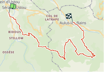
![](/images/other/stat-length.png)
![Trail Walking Ustou - GR10 2022 - J2 bis - Photo](https://media.geolcdn.com/t/1900/400/ext.pjpeg?maxdim=2&url=https%3A%2F%2Fstatic1.geolcdn.com%2Fsiteimages%2Fupload%2Ffiles%2F1553511878bg_sport_marche.png)
GR10 2022 - J2 bis
JM Heine
User
![Length](/images/other/stat-length.png)
Length
22 km
![Max alt](https://static1.geolcdn.com/siteimages/upload/files/1508320355ic_sort_altitude_max_24dp.png)
Max alt
1656 m
![Uphill gradient](https://static1.geolcdn.com/siteimages/upload/files/1508320355ic_sort_den_pos_24dp.png)
Uphill gradient
1439 m
![Km-Effort](/images/other/stat-length.png)
Km-Effort
41 km
![Min alt](https://static1.geolcdn.com/siteimages/upload/files/1508320355ic_sort_altitude_min_24dp.png)
Min alt
731 m
![Downhill gradient](https://static1.geolcdn.com/siteimages/upload/files/1508320355ic_sort_den_neg_24dp.png)
Downhill gradient
1426 m
![Boucle](https://static1.geolcdn.com/siteimages/upload/files/16400158638029165_repeat_loop_refresh_sync_direction_icon.png)
Boucle
No
Creation date :
2022-05-20 19:50:51.191
Updated on :
2022-07-31 14:30:29.915
![Walking](https://static1.geolcdn.com/sitytour/trail-icons/101.png)
9h21
Difficulty : Very difficult
![Scan this QR Code to open this trail in the SityTrail application](https://capi.geolives.com/qq0zvz2zws4bq2lad0pu/sitytour/trails/3250596/qr.png?size=200)
FREE GPS app for hiking
About
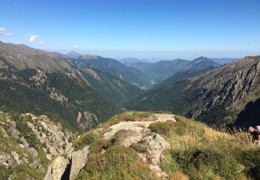
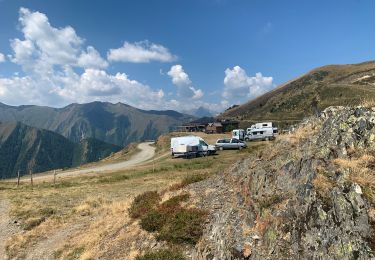
Trail Walking of 22 km to be discovered at Occitania, Ariège, Ustou. This trail is proposed by JM Heine.
Description
Départ du gîte d'étape La Colline Verte à St Lizier d'Ustou.
650m après la cascade de Fouillet, un raccourci est possible via 1 GRP : voir GR10 2022 - J2
Arrivée : Résidence "Aux Volets bleus d'Aulus" : 06 77 24 10 23
Positioning
Country:
France
Region :
Occitania
Department/Province :
Ariège
Municipality :
Ustou
Location:
Unknown
Start:(Dec)
Start:(UTM)
358001 ; 4740043 (31T) N.
Comments
Trails nearby
![Trail Walking Ustou - Col de serre - Photo](https://media.geolcdn.com/t/375/260/9b0ff7ec-3f70-4e2e-a460-cdf6da735670.jpeg&format=jpg&maxdim=2)
![Walking Walking](https://static1.geolcdn.com/sitytour/trail-icons/101.png)
![Trail Walking Ustou - Le tour de la cabane d'Ardio - Photo](https://media.geolcdn.com/t/375/260/ext.jpg?maxdim=2&url=https%3A%2F%2Fservices.sitytrail.com%2FGeolivesWS%2FDownloadMedia.ashx%3FTrailID%3D109129%26Media%3D3169_1.jpg)
![Walking Walking](https://static1.geolcdn.com/sitytour/trail-icons/101.png)
Le tour de la cabane d'Ardio
Walking
Medium
(1)
Ustou,
Occitania,
Ariège,
France
![](/images/other/stat-length.png)
4.4 km | 7.1 km-effort
1h 30min
![](https://static1.geolcdn.com/siteimages/upload/files/16400158638029165_repeat_loop_refresh_sync_direction_icon.png)
Yes
![Trail Walking Ustou - Les Cascades du chemin d'Espagne - Photo](https://media.geolcdn.com/t/375/260/ext.jpg?maxdim=2&url=https%3A%2F%2Fservices.sitytrail.com%2FGeolivesWS%2FDownloadMedia.ashx%3FTrailID%3D109125%26Media%3D3166_1.jpg)
![Walking Walking](https://static1.geolcdn.com/sitytour/trail-icons/101.png)
Les Cascades du chemin d'Espagne
Walking
Medium
(1)
Ustou,
Occitania,
Ariège,
France
![](/images/other/stat-length.png)
8.1 km | 13.1 km-effort
2h 30min
![](https://static1.geolcdn.com/siteimages/upload/files/16400158638029165_repeat_loop_refresh_sync_direction_icon.png)
Yes
![Trail Walking Ustou - Alet lacarde - Photo](https://media.geolcdn.com/t/375/260/27892605-2437-41ef-be78-41576cffc567.jpg&format=jpg&maxdim=2)
![Walking Walking](https://static1.geolcdn.com/sitytour/trail-icons/101.png)
Alet lacarde
Walking
Very difficult
Ustou,
Occitania,
Ariège,
France
![](/images/other/stat-length.png)
13.3 km | 30 km-effort
6h 22min
![](https://static1.geolcdn.com/siteimages/upload/files/16400158638029165_repeat_loop_refresh_sync_direction_icon.png)
Yes
![Trail On foot Ustou - Le cirque de Cagateille - Photo](https://media.geolcdn.com/t/375/260/b85b23f9-0171-4dba-9255-58e8e46a4892.jpeg&format=jpg&maxdim=2)
![On foot On foot](https://static1.geolcdn.com/sitytour/trail-icons/100.png)
Le cirque de Cagateille
On foot
Medium
Ustou,
Occitania,
Ariège,
France
![](/images/other/stat-length.png)
11.1 km | 26 km-effort
5h 49min
![](https://static1.geolcdn.com/siteimages/upload/files/16400158638029165_repeat_loop_refresh_sync_direction_icon.png)
Yes
![Trail On foot Ustou - Pic de Couillac par le cirque de Cagateille - Photo](https://media.geolcdn.com/t/375/260/b85b23f9-0171-4dba-9255-58e8e46a4892.jpeg&format=jpg&maxdim=2)
![On foot On foot](https://static1.geolcdn.com/sitytour/trail-icons/100.png)
Pic de Couillac par le cirque de Cagateille
On foot
Difficult
Ustou,
Occitania,
Ariège,
France
![](/images/other/stat-length.png)
16.3 km | 39 km-effort
8h 52min
![](https://static1.geolcdn.com/siteimages/upload/files/16400158638029165_repeat_loop_refresh_sync_direction_icon.png)
Yes
![Trail Walking Ustou - Ustou - Photo](https://media.geolcdn.com/t/375/260/6a47a3e3-0a99-4be0-b03a-9e74ce0dfd69.jpg&format=jpg&maxdim=2)
![Walking Walking](https://static1.geolcdn.com/sitytour/trail-icons/101.png)
![Trail Walking Ustou - Cagateille - Certascan - Photo](https://media.geolcdn.com/t/375/260/1d9be698-3fc9-4fef-b6ba-8a2be6645e5c.jpeg&format=jpg&maxdim=2)
![Walking Walking](https://static1.geolcdn.com/sitytour/trail-icons/101.png)
Cagateille - Certascan
Walking
Very difficult
Ustou,
Occitania,
Ariège,
France
![](/images/other/stat-length.png)
10.4 km | 29 km-effort
8h 0min
![](https://static1.geolcdn.com/siteimages/upload/files/16400158638029165_repeat_loop_refresh_sync_direction_icon.png)
No
![Trail Walking Ustou - 2022 TRANSPYRÉNÉEN - St Lizier -d’Ustou -Aulus les Bains - Photo](https://media.geolcdn.com/t/375/260/fe127ba5-265b-4ae4-b883-31d9e39fedfd.jpg&format=jpg&maxdim=2)
![Walking Walking](https://static1.geolcdn.com/sitytour/trail-icons/101.png)
2022 TRANSPYRÉNÉEN - St Lizier -d’Ustou -Aulus les Bains
Walking
Very difficult
Ustou,
Occitania,
Ariège,
France
![](/images/other/stat-length.png)
17.5 km | 33 km-effort
4h 40min
![](https://static1.geolcdn.com/siteimages/upload/files/16400158638029165_repeat_loop_refresh_sync_direction_icon.png)
No