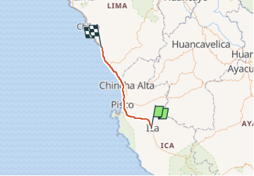
![Trail Car Ica - Ica a Lima - Photo](https://media.geolcdn.com/t/1900/400/ext.pjpeg?maxdim=2&url=https%3A%2F%2Fstatic1.geolcdn.com%2Fsiteimages%2Fupload%2Ffiles%2F15247431544x4.jpg)
Ica a Lima
carolemao
User
![Length](/images/other/stat-length.png)
Length
184 km
![Max alt](https://static1.geolcdn.com/siteimages/upload/files/1508320355ic_sort_altitude_max_24dp.png)
Max alt
440 m
![Uphill gradient](https://static1.geolcdn.com/siteimages/upload/files/1508320355ic_sort_den_pos_24dp.png)
Uphill gradient
1678 m
![Km-Effort](/images/other/stat-length.png)
Km-Effort
207 km
![Min alt](https://static1.geolcdn.com/siteimages/upload/files/1508320355ic_sort_altitude_min_24dp.png)
Min alt
-5 m
![Downhill gradient](https://static1.geolcdn.com/siteimages/upload/files/1508320355ic_sort_den_neg_24dp.png)
Downhill gradient
1972 m
![Boucle](https://static1.geolcdn.com/siteimages/upload/files/16400158638029165_repeat_loop_refresh_sync_direction_icon.png)
Boucle
No
Creation date :
2022-05-17 12:33:50.0
Updated on :
2022-05-17 18:37:51.126
![Car](https://static1.geolcdn.com/sitytour/trail-icons/401.png)
2h24
Difficulty : Unknown
![Scan this QR Code to open this trail in the SityTrail application](https://capi.geolives.com/qq0zvz2zws4bq2lad0pu/sitytour/trails/3246864/qr.png?size=200)
FREE GPS app for hiking
About
Trail Car of 184 km to be discovered at Ica, Province of Ica, Ica. This trail is proposed by carolemao.
Positioning
Country:
Peru
Region :
Ica
Department/Province :
Province of Ica
Municipality :
Ica
Location:
Unknown
Start:(Dec)
Start:(UTM)
419063 ; 8443138 (18L) S.
Comments
Trails nearby