![](/images/other/stat-length.png)
![Trail Walking Besse - 3ème étape : Besse au Châlet du Fay - Photo](https://media.geolcdn.com/t/1900/400/ext.pjpeg?maxdim=2&url=https%3A%2F%2Fstatic1.geolcdn.com%2Fsiteimages%2Fupload%2Ffiles%2F1553511878bg_sport_marche.png)
3ème étape : Besse au Châlet du Fay
randotines
User GUIDE
![Length](/images/other/stat-length.png)
Length
8.4 km
![Max alt](https://static1.geolcdn.com/siteimages/upload/files/1508320355ic_sort_altitude_max_24dp.png)
Max alt
2265 m
![Uphill gradient](https://static1.geolcdn.com/siteimages/upload/files/1508320355ic_sort_den_pos_24dp.png)
Uphill gradient
821 m
![Km-Effort](/images/other/stat-length.png)
Km-Effort
17 km
![Min alt](https://static1.geolcdn.com/siteimages/upload/files/1508320355ic_sort_altitude_min_24dp.png)
Min alt
1540 m
![Downhill gradient](https://static1.geolcdn.com/siteimages/upload/files/1508320355ic_sort_den_neg_24dp.png)
Downhill gradient
106 m
![Boucle](https://static1.geolcdn.com/siteimages/upload/files/16400158638029165_repeat_loop_refresh_sync_direction_icon.png)
Boucle
No
Creation date :
2014-12-10 00:00:00.0
Updated on :
2014-12-10 00:00:00.0
![Walking](https://static1.geolcdn.com/sitytour/trail-icons/101.png)
3h50
Difficulty : Difficult
![Scan this QR Code to open this trail in the SityTrail application](https://capi.geolives.com/qq0zvz2zws4bq2lad0pu/sitytour/trails/324211/qr.png?size=200)
FREE GPS app for hiking
About
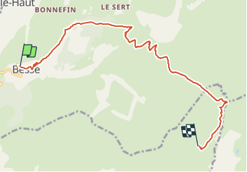
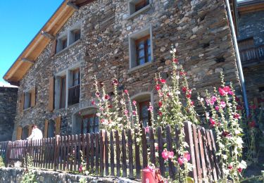
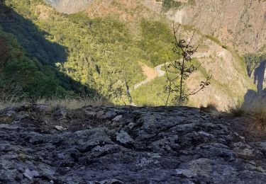
Trail Walking of 8.4 km to be discovered at Auvergne-Rhône-Alpes, Isère, Besse. This trail is proposed by randotines.
Description
J'ai raccourci l'étape en faisant un transfert de Clavans le bas à Besse car montée raide entre le Moulin et Besse ( 2km en moins )
Positioning
Country:
France
Region :
Auvergne-Rhône-Alpes
Department/Province :
Isère
Municipality :
Besse
Location:
Unknown
Start:(Dec)
Start:(UTM)
277110 ; 4994849 (32T) N.
Comments
Trails nearby
![Trail Walking Mizoën - 2020-09-05 Marche Refuge Fay Plateau Emparis La Grave - Photo](https://media.geolcdn.com/t/375/260/fad0353c-ad9c-4623-b445-e391df98cbf1.jpg&format=jpg&maxdim=2)
![Walking Walking](https://static1.geolcdn.com/sitytour/trail-icons/101.png)
2020-09-05 Marche Refuge Fay Plateau Emparis La Grave
Walking
Easy
Mizoën,
Auvergne-Rhône-Alpes,
Isère,
France
![](/images/other/stat-length.png)
21 km | 33 km-effort
6h 23min
![](https://static1.geolcdn.com/siteimages/upload/files/16400158638029165_repeat_loop_refresh_sync_direction_icon.png)
No
![Trail Touring skiing Clavans-en-Haut-Oisans - col du milieu au départ du col de Sarenne - Photo](https://media.geolcdn.com/t/375/260/f27aadb4-937b-481a-8166-c706d88b2606.jpg&format=jpg&maxdim=2)
![Touring skiing Touring skiing](https://static1.geolcdn.com/sitytour/trail-icons/503.png)
col du milieu au départ du col de Sarenne
Touring skiing
Medium
Clavans-en-Haut-Oisans,
Auvergne-Rhône-Alpes,
Isère,
France
![](/images/other/stat-length.png)
17.6 km | 38 km-effort
9h 11min
![](https://static1.geolcdn.com/siteimages/upload/files/16400158638029165_repeat_loop_refresh_sync_direction_icon.png)
Yes
![Trail Touring skiing Le Freney-d'Oisans - pic blanc - Photo](https://media.geolcdn.com/t/375/260/4389279f-2a15-49e6-bc1c-70bf2118c5f4.jpg&format=jpg&maxdim=2)
![Touring skiing Touring skiing](https://static1.geolcdn.com/sitytour/trail-icons/503.png)
pic blanc
Touring skiing
Easy
Le Freney-d'Oisans,
Auvergne-Rhône-Alpes,
Isère,
France
![](/images/other/stat-length.png)
15.1 km | 36 km-effort
8h 11min
![](https://static1.geolcdn.com/siteimages/upload/files/16400158638029165_repeat_loop_refresh_sync_direction_icon.png)
Yes
![Trail Walking Mizoën - Lac de Lovitel et fontaine pétrifiante depuis Aymes - Photo](https://media.geolcdn.com/t/375/260/ext.jpg?maxdim=2&url=https%3A%2F%2Fstatic1.geolcdn.com%2Fsiteimages%2Fupload%2Ffiles%2F1553511878bg_sport_marche.png)
![Walking Walking](https://static1.geolcdn.com/sitytour/trail-icons/101.png)
Lac de Lovitel et fontaine pétrifiante depuis Aymes
Walking
Very easy
(1)
Mizoën,
Auvergne-Rhône-Alpes,
Isère,
France
![](/images/other/stat-length.png)
8.6 km | 14.5 km-effort
3h 56min
![](https://static1.geolcdn.com/siteimages/upload/files/16400158638029165_repeat_loop_refresh_sync_direction_icon.png)
Yes
![Trail Electric bike Les Deux Alpes - plateau d'Emparis - Photo](https://media.geolcdn.com/t/375/260/e0e5c364-faf9-450f-8107-1f1f65fd8d5d.jpg&format=jpg&maxdim=2)
![Electric bike Electric bike](https://static1.geolcdn.com/sitytour/trail-icons/205.png)
plateau d'Emparis
Electric bike
Medium
(2)
Les Deux Alpes,
Auvergne-Rhône-Alpes,
Isère,
France
![](/images/other/stat-length.png)
42 km | 64 km-effort
Unknown
![](https://static1.geolcdn.com/siteimages/upload/files/16400158638029165_repeat_loop_refresh_sync_direction_icon.png)
Yes
![Trail Walking Clavans-en-Haut-Oisans - 28 juin 2023 lac des quirlies - Photo](https://media.geolcdn.com/t/375/260/4cf39f43-9b8a-4cab-bfca-4ad5cd532fd2.jpg&format=jpg&maxdim=2)
![Walking Walking](https://static1.geolcdn.com/sitytour/trail-icons/101.png)
28 juin 2023 lac des quirlies
Walking
Very difficult
Clavans-en-Haut-Oisans,
Auvergne-Rhône-Alpes,
Isère,
France
![](/images/other/stat-length.png)
17.7 km | 32 km-effort
7h 21min
![](https://static1.geolcdn.com/siteimages/upload/files/16400158638029165_repeat_loop_refresh_sync_direction_icon.png)
Yes
![Trail Walking Mizoën - Les clots Fontaine pétrifiantes - Photo](https://media.geolcdn.com/t/375/260/93b27018-4ceb-4fb4-8de2-f3ada8d4d4e1.jpg&format=jpg&maxdim=2)
![Walking Walking](https://static1.geolcdn.com/sitytour/trail-icons/101.png)
Les clots Fontaine pétrifiantes
Walking
Very difficult
Mizoën,
Auvergne-Rhône-Alpes,
Isère,
France
![](/images/other/stat-length.png)
8.9 km | 19.7 km-effort
3h 4min
![](https://static1.geolcdn.com/siteimages/upload/files/16400158638029165_repeat_loop_refresh_sync_direction_icon.png)
Yes
![Trail Walking Besse - Plateau d'Emparis 26.8.22 - Photo](https://media.geolcdn.com/t/375/260/ce2a87ab-6168-4ac7-b430-4d580996bb5d.jpg&format=jpg&maxdim=2)
![Walking Walking](https://static1.geolcdn.com/sitytour/trail-icons/101.png)
Plateau d'Emparis 26.8.22
Walking
Easy
Besse,
Auvergne-Rhône-Alpes,
Isère,
France
![](/images/other/stat-length.png)
7.9 km | 12.8 km-effort
2h 50min
![](https://static1.geolcdn.com/siteimages/upload/files/16400158638029165_repeat_loop_refresh_sync_direction_icon.png)
Yes
![Trail Walking Les Deux Alpes - Bons porte romaine - Photo](https://media.geolcdn.com/t/375/260/e953dd9b-92c2-4085-b1ca-d9ed03ffa9de.jpg&format=jpg&maxdim=2)
![Walking Walking](https://static1.geolcdn.com/sitytour/trail-icons/101.png)
Bons porte romaine
Walking
Medium
Les Deux Alpes,
Auvergne-Rhône-Alpes,
Isère,
France
![](/images/other/stat-length.png)
6.9 km | 11.9 km-effort
2h 40min
![](https://static1.geolcdn.com/siteimages/upload/files/16400158638029165_repeat_loop_refresh_sync_direction_icon.png)
Yes