![](/images/other/stat-length.png)
![Trail Walking Bagneux - Bagneux, les ruisseaux, les noues, la dérivation de l'Aube - Photo](https://media.geolcdn.com/t/1900/400/0fca4454-acf4-40ad-bf2c-7ef6132dd52a.jpg&format=pjpeg&maxdim=2)
Bagneux, les ruisseaux, les noues, la dérivation de l'Aube
jeannine grandjean
User
![Length](/images/other/stat-length.png)
Length
10.6 km
![Max alt](https://static1.geolcdn.com/siteimages/upload/files/1508320355ic_sort_altitude_max_24dp.png)
Max alt
77 m
![Uphill gradient](https://static1.geolcdn.com/siteimages/upload/files/1508320355ic_sort_den_pos_24dp.png)
Uphill gradient
51 m
![Km-Effort](/images/other/stat-length.png)
Km-Effort
11.3 km
![Min alt](https://static1.geolcdn.com/siteimages/upload/files/1508320355ic_sort_altitude_min_24dp.png)
Min alt
68 m
![Downhill gradient](https://static1.geolcdn.com/siteimages/upload/files/1508320355ic_sort_den_neg_24dp.png)
Downhill gradient
52 m
![Boucle](https://static1.geolcdn.com/siteimages/upload/files/16400158638029165_repeat_loop_refresh_sync_direction_icon.png)
Boucle
No
Creation date :
2022-05-10 07:39:25.849
Updated on :
2022-05-11 07:49:39.36
![Walking](https://static1.geolcdn.com/sitytour/trail-icons/101.png)
2h40
Difficulty : Medium
![Scan this QR Code to open this trail in the SityTrail application](https://capi.geolives.com/qq0zvz2zws4bq2lad0pu/sitytour/trails/3236640/qr.png?size=200)
FREE GPS app for hiking
About
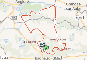
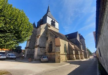
Trail Walking of 10.6 km to be discovered at Grand Est, Marne, Bagneux. This trail is proposed by jeannine grandjean.
Description
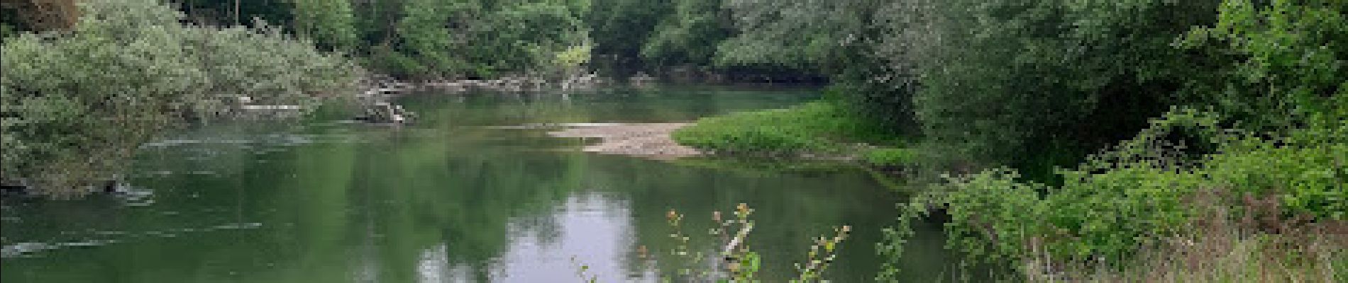
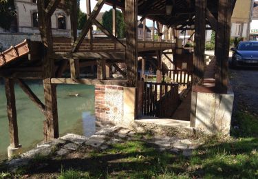
agréable parcours (au départ de l'église) qui longe en grande partie le ruisseau de la Sodoyère ainsi que la dérivation de l'Aube appelée "la Vieille", à la limite d'Anglure. Passage par la Noue d'Aval et retour par le hameau de Bécheret
Positioning
Country:
France
Region :
Grand Est
Department/Province :
Marne
Municipality :
Bagneux
Location:
Unknown
Start:(Dec)
Start:(UTM)
561192 ; 5378886 (31U) N.
Comments
Trails nearby
![Trail Walking Anglure - Au fil de l'Aube - Photo](https://media.geolcdn.com/t/375/260/ext.jpg?maxdim=2&url=https%3A%2F%2Fservices.sitytrail.com%2FGeolivesWS%2FDownloadMedia.ashx%3FTrailID%3D474781%26Media%3D20150923162600.jpg)
![Walking Walking](https://static1.geolcdn.com/sitytour/trail-icons/101.png)
Au fil de l'Aube
Walking
Very easy
Anglure,
Grand Est,
Marne,
France
![](/images/other/stat-length.png)
10.5 km | 11.2 km-effort
2h 7min
![](https://static1.geolcdn.com/siteimages/upload/files/16400158638029165_repeat_loop_refresh_sync_direction_icon.png)
Yes
![Trail Walking Saint-Just-Sauvage - St Just 6km - Photo](https://media.geolcdn.com/t/375/260/5825313c-7a40-476c-be25-f21d1a56f2bc.jpg&format=jpg&maxdim=2)
![Walking Walking](https://static1.geolcdn.com/sitytour/trail-icons/101.png)
St Just 6km
Walking
Easy
Saint-Just-Sauvage,
Grand Est,
Marne,
France
![](/images/other/stat-length.png)
6 km | 6.3 km-effort
1h 45min
![](https://static1.geolcdn.com/siteimages/upload/files/16400158638029165_repeat_loop_refresh_sync_direction_icon.png)
Yes
![Trail Hybrid bike Saint-Just-Sauvage - velovoie saint juste crancey - Photo](https://media.geolcdn.com/t/375/260/ext.jpg?maxdim=2&url=https%3A%2F%2Fstatic1.geolcdn.com%2Fsiteimages%2Fupload%2Ffiles%2F1524743154velo.jpg)
![Hybrid bike Hybrid bike](https://static1.geolcdn.com/sitytour/trail-icons/203.png)
velovoie saint juste crancey
Hybrid bike
Easy
Saint-Just-Sauvage,
Grand Est,
Marne,
France
![](/images/other/stat-length.png)
26 km | 28 km-effort
2h 6min
![](https://static1.geolcdn.com/siteimages/upload/files/16400158638029165_repeat_loop_refresh_sync_direction_icon.png)
Yes
![Trail Walking Saint-Just-Sauvage - Par les terres - Photo](https://media.geolcdn.com/t/375/260/ext.jpg?maxdim=2&url=https%3A%2F%2Fstatic1.geolcdn.com%2Fsiteimages%2Fupload%2Ffiles%2F1553511878bg_sport_marche.png)
![Walking Walking](https://static1.geolcdn.com/sitytour/trail-icons/101.png)
Par les terres
Walking
Very easy
Saint-Just-Sauvage,
Grand Est,
Marne,
France
![](/images/other/stat-length.png)
10.7 km | 11.2 km-effort
2h 31min
![](https://static1.geolcdn.com/siteimages/upload/files/16400158638029165_repeat_loop_refresh_sync_direction_icon.png)
Yes
![Trail Walking Saint-Just-Sauvage - Saint Just canal et vers Sauvage par la campagne - Photo](https://media.geolcdn.com/t/375/260/ext.jpg?maxdim=2&url=https%3A%2F%2Fstatic1.geolcdn.com%2Fsiteimages%2Fupload%2Ffiles%2F1553511878bg_sport_marche.png)
![Walking Walking](https://static1.geolcdn.com/sitytour/trail-icons/101.png)
Saint Just canal et vers Sauvage par la campagne
Walking
Very easy
Saint-Just-Sauvage,
Grand Est,
Marne,
France
![](/images/other/stat-length.png)
7.3 km | 7.7 km-effort
1h 43min
![](https://static1.geolcdn.com/siteimages/upload/files/16400158638029165_repeat_loop_refresh_sync_direction_icon.png)
Yes
![Trail Walking Anglure - Au fil de l'Aube - Photo](https://media.geolcdn.com/t/375/260/ext.jpg?maxdim=2&url=https%3A%2F%2Fstatic1.geolcdn.com%2Fsiteimages%2Fupload%2Ffiles%2F1553511878bg_sport_marche.png)
![Walking Walking](https://static1.geolcdn.com/sitytour/trail-icons/101.png)
![Trail Walking Anglure - Anglure - Photo](https://media.geolcdn.com/t/375/260/ext.jpg?maxdim=2&url=https%3A%2F%2Fstatic1.geolcdn.com%2Fsiteimages%2Fupload%2Ffiles%2F1553511878bg_sport_marche.png)
![Walking Walking](https://static1.geolcdn.com/sitytour/trail-icons/101.png)
![Trail sport Clesles - Clesles Seine - Photo](https://media.geolcdn.com/t/375/260/ext.jpg?maxdim=2&url=https%3A%2F%2Fsecurestorage.geolives.com%2Fsitytour%2Ftrail-bg%2Fdefault.jpg)
![Trail Nordic walking Bagneux - Bagneux à Savières - Photo](https://media.geolcdn.com/t/375/260/ext.jpg?maxdim=2&url=https%3A%2F%2Fstatic1.geolcdn.com%2Fsiteimages%2Fupload%2Ffiles%2F1545311037marcheuse_200dpi.jpg)
![Nordic walking Nordic walking](https://static1.geolcdn.com/sitytour/trail-icons/102.png)
Bagneux à Savières
Nordic walking
Medium
Bagneux,
Grand Est,
Marne,
France
![](/images/other/stat-length.png)
28 km | 29 km-effort
6h 8min
![](https://static1.geolcdn.com/siteimages/upload/files/16400158638029165_repeat_loop_refresh_sync_direction_icon.png)
No