


evora1

Lucdelmoitie
User
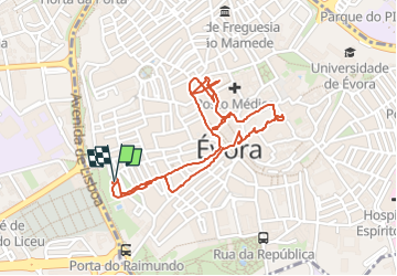

Length
2.8 km

Max alt
310 m

Uphill gradient
37 m
Km-Effort
3.3 km

Min alt
277 m

Downhill gradient
37 m
Boucle
Yes
Creation date :
2022-05-09 14:49:13.695
Updated on :
2022-05-09 16:28:17.831
1h38
Difficulty : Easy

FREE GPS app for hiking
 SityTrail
IGN / Geographical institutes
SityTrail World
The world is yours!
About
Trail Walking of 2.8 km to be discovered at Alentejo Region, Évora, Évora. This trail is proposed by Lucdelmoitie.
Positioning
Country:
Portugal
Region :
Alentejo Region
Department/Province :
Évora
Municipality :
Évora
Location:
Santo Antão
Start:(Dec)
Start:(UTM)
594631 ; 4269603 (29S) N.
Comments
Trails nearby