![](/images/other/stat-length.png)
![Trail Walking Saint-Antonin-Noble-Val - Michel_Picard_2022-05-05_10-53-48 - Photo](https://media.geolcdn.com/t/1900/400/ext.pjpeg?maxdim=2&url=https%3A%2F%2Fstatic1.geolcdn.com%2Fsiteimages%2Fupload%2Ffiles%2F1553511878bg_sport_marche.png)
Michel_Picard_2022-05-05_10-53-48
mipi31
User
![Length](/images/other/stat-length.png)
![Max alt](https://static1.geolcdn.com/siteimages/upload/files/1508320355ic_sort_altitude_max_24dp.png)
![Uphill gradient](https://static1.geolcdn.com/siteimages/upload/files/1508320355ic_sort_den_pos_24dp.png)
![Km-Effort](/images/other/stat-length.png)
![Min alt](https://static1.geolcdn.com/siteimages/upload/files/1508320355ic_sort_altitude_min_24dp.png)
![Downhill gradient](https://static1.geolcdn.com/siteimages/upload/files/1508320355ic_sort_den_neg_24dp.png)
![Boucle](https://static1.geolcdn.com/siteimages/upload/files/16400158638029165_repeat_loop_refresh_sync_direction_icon.png)
![Walking](https://static1.geolcdn.com/sitytour/trail-icons/101.png)
4h47
Difficulty : Medium
![Scan this QR Code to open this trail in the SityTrail application](https://capi.geolives.com/qq0zvz2zws4bq2lad0pu/sitytour/trails/3231041/qr.png?size=200)
FREE GPS app for hiking
About
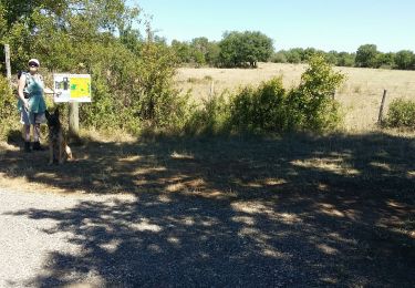
Trail Walking of 15.3 km to be discovered at Occitania, Tarn-et-Garonne, Saint-Antonin-Noble-Val. This trail is proposed by mipi31.
Description
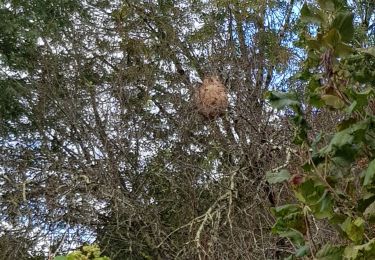
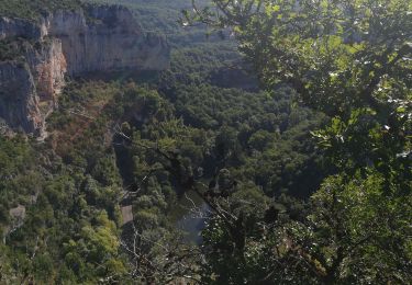
Très belle boucle depuis Saint Antonin Noble Val. On monte assez rapidement sur le causse pour évoluer en bordure du plateau calcaire jusqu’au cirque qui surplombe le ruisseau de Nibousou. Restes de terrasses et vue sur Saint Antonin. Puis on bifurque sur le plateau. Beaux sentiers dans le sous-bois, on descend de 80 mètres pour traverser un vallon et se retrouver à nouveau sur le causse. Zone de cultures et d’élevage. Avec toujours de beaux sentiers. On poursuit par un petit kilomètre de route très peu fréquentée sans problème particulier. Puis alternance de petites routes et de très beaux chemins pour rejoindre la crête qui surplombe l’Aveyron à l’Est de Saint Antonin, ce qui nous permet de découvrir de nouveaux paysages. Puis descente assez raide avec vue plongeante sur la vieille ville.
Positioning
Comments
Trails nearby
![Trail Walking Saint-Antonin-Noble-Val - Saint antonin. PR10 - Photo](https://media.geolcdn.com/t/375/260/ext.jpg?maxdim=2&url=https%3A%2F%2Fstatic1.geolcdn.com%2Fsiteimages%2Fupload%2Ffiles%2F1553511878bg_sport_marche.png)
![Walking Walking](https://static1.geolcdn.com/sitytour/trail-icons/101.png)
Walking
![](/images/other/stat-length.png)
![](https://static1.geolcdn.com/siteimages/upload/files/16400158638029165_repeat_loop_refresh_sync_direction_icon.png)
![Trail Walking Saint-Antonin-Noble-Val - Saint Antonin Noble Val pat le cirque de Nibousou - Photo](https://media.geolcdn.com/t/375/260/8d980b9f-e92a-41a7-8258-3fe72bbabf45.jpg&format=jpg&maxdim=2)
![Walking Walking](https://static1.geolcdn.com/sitytour/trail-icons/101.png)
Walking
![](/images/other/stat-length.png)
![](https://static1.geolcdn.com/siteimages/upload/files/16400158638029165_repeat_loop_refresh_sync_direction_icon.png)
![Trail Walking Saint-Antonin-Noble-Val - Saint Antonin Noble Val - côte de Ouf et cirque de Baune - Photo](https://media.geolcdn.com/t/375/260/ede720ec-eee1-4146-9fff-5e7b3cd1b281.jpg&format=jpg&maxdim=2)
![Walking Walking](https://static1.geolcdn.com/sitytour/trail-icons/101.png)
Walking
![](/images/other/stat-length.png)
![](https://static1.geolcdn.com/siteimages/upload/files/16400158638029165_repeat_loop_refresh_sync_direction_icon.png)
![Trail Walking Saint-Antonin-Noble-Val - Saint antonin Brousses P23 - Photo](https://media.geolcdn.com/t/375/260/57698089-0092-4b74-9970-f68a51da5e4b.jpg&format=jpg&maxdim=2)
![Walking Walking](https://static1.geolcdn.com/sitytour/trail-icons/101.png)
Walking
![](/images/other/stat-length.png)
![](https://static1.geolcdn.com/siteimages/upload/files/16400158638029165_repeat_loop_refresh_sync_direction_icon.png)
![Trail Walking Saint-Antonin-Noble-Val - sentier de Lou Finot - Photo](https://media.geolcdn.com/t/375/260/707dd8d2-e9cf-48af-9952-0ef10b48f714.jpg&format=jpg&maxdim=2)
![Walking Walking](https://static1.geolcdn.com/sitytour/trail-icons/101.png)
Walking
![](/images/other/stat-length.png)
![](https://static1.geolcdn.com/siteimages/upload/files/16400158638029165_repeat_loop_refresh_sync_direction_icon.png)
![Trail Walking Saint-Antonin-Noble-Val - sentier des gorges st Antonin - Photo](https://media.geolcdn.com/t/375/260/ext.jpg?maxdim=2&url=https%3A%2F%2Fstatic1.geolcdn.com%2Fsiteimages%2Fupload%2Ffiles%2F1553511878bg_sport_marche.png)
![Walking Walking](https://static1.geolcdn.com/sitytour/trail-icons/101.png)
Walking
![](/images/other/stat-length.png)
![](https://static1.geolcdn.com/siteimages/upload/files/16400158638029165_repeat_loop_refresh_sync_direction_icon.png)
![Trail Walking Saint-Antonin-Noble-Val - Saint-Antonin Noble-le-Val - Photo](https://media.geolcdn.com/t/375/260/ext.jpg?maxdim=2&url=https%3A%2F%2Fstatic1.geolcdn.com%2Fsiteimages%2Fupload%2Ffiles%2F1553511878bg_sport_marche.png)
![Walking Walking](https://static1.geolcdn.com/sitytour/trail-icons/101.png)
Walking
![](/images/other/stat-length.png)
![](https://static1.geolcdn.com/siteimages/upload/files/16400158638029165_repeat_loop_refresh_sync_direction_icon.png)
![Trail Walking Saint-Antonin-Noble-Val - Saint Antonin Noble Val - Photo](https://media.geolcdn.com/t/375/260/ext.jpg?maxdim=2&url=https%3A%2F%2Fstatic1.geolcdn.com%2Fsiteimages%2Fupload%2Ffiles%2F1553511878bg_sport_marche.png)
![Walking Walking](https://static1.geolcdn.com/sitytour/trail-icons/101.png)
Walking
![](/images/other/stat-length.png)
![](https://static1.geolcdn.com/siteimages/upload/files/16400158638029165_repeat_loop_refresh_sync_direction_icon.png)
![Trail Walking Saint-Antonin-Noble-Val - Rando n° 4 St Anto Penne Cazals Saint Anto - Photo](https://media.geolcdn.com/t/375/260/ext.jpg?maxdim=2&url=https%3A%2F%2Fstatic1.geolcdn.com%2Fsiteimages%2Fupload%2Ffiles%2F1553511878bg_sport_marche.png)
![Walking Walking](https://static1.geolcdn.com/sitytour/trail-icons/101.png)
Walking
![](/images/other/stat-length.png)
![](https://static1.geolcdn.com/siteimages/upload/files/16400158638029165_repeat_loop_refresh_sync_direction_icon.png)