![](/images/other/stat-length.png)
![Trail Walking Sainte-Léocadie - la cerdagne se raconte - Photo](https://media.geolcdn.com/t/1900/400/ext.pjpeg?maxdim=2&url=https%3A%2F%2Fservices.sitytrail.com%2FGeolivesWS%2FDownloadMedia.ashx%3FTrailID%3D323086%26Media%3Dfix__20140711095944.jpg)
la cerdagne se raconte
carapitouille
User
![Length](/images/other/stat-length.png)
Length
5.8 km
![Max alt](https://static1.geolcdn.com/siteimages/upload/files/1508320355ic_sort_altitude_max_24dp.png)
Max alt
1376 m
![Uphill gradient](https://static1.geolcdn.com/siteimages/upload/files/1508320355ic_sort_den_pos_24dp.png)
Uphill gradient
104 m
![Km-Effort](/images/other/stat-length.png)
Km-Effort
7.5 km
![Min alt](https://static1.geolcdn.com/siteimages/upload/files/1508320355ic_sort_altitude_min_24dp.png)
Min alt
1236 m
![Downhill gradient](https://static1.geolcdn.com/siteimages/upload/files/1508320355ic_sort_den_neg_24dp.png)
Downhill gradient
180 m
![Boucle](https://static1.geolcdn.com/siteimages/upload/files/16400158638029165_repeat_loop_refresh_sync_direction_icon.png)
Boucle
No
Creation date :
2014-12-10 00:00:00.0
Updated on :
2014-12-10 00:00:00.0
![Walking](https://static1.geolcdn.com/sitytour/trail-icons/101.png)
2h04
Difficulty : Easy
![Scan this QR Code to open this trail in the SityTrail application](https://capi.geolives.com/qq0zvz2zws4bq2lad0pu/sitytour/trails/323086/qr.png?size=200)
FREE GPS app for hiking
About
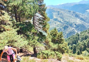
Trail Walking of 5.8 km to be discovered at Occitania, Pyrénées-Orientales, Sainte-Léocadie. This trail is proposed by carapitouille.
Description
aller a osseja en voiture;y prendre le train jaune jusqu'a la premiere gare;commencer la randonnee qui vous conduira jusqu'a l'endroit ou vous avez laisse votre vehicule;
Positioning
Country:
France
Region :
Occitania
Department/Province :
Pyrénées-Orientales
Municipality :
Sainte-Léocadie
Location:
Unknown
Start:(Dec)
Start:(UTM)
418553 ; 4699163 (31T) N.
Comments
Trails nearby
![Trail Walking Nahuja - boucle de Nahuja - Photo](https://media.geolcdn.com/t/375/260/ext.jpg?maxdim=2&url=https%3A%2F%2Fservices.sitytrail.com%2FGeolivesWS%2FDownloadMedia.ashx%3FTrailID%3D558835%26Media%3D20160425135530.jpg)
![Walking Walking](https://static1.geolcdn.com/sitytour/trail-icons/101.png)
boucle de Nahuja
Walking
Medium
(1)
Nahuja,
Occitania,
Pyrénées-Orientales,
France
![](/images/other/stat-length.png)
11.8 km | 18.2 km-effort
2h 44min
![](https://static1.geolcdn.com/siteimages/upload/files/16400158638029165_repeat_loop_refresh_sync_direction_icon.png)
Yes
![Trail sport Saillagouse - 20240623 Saillagouse -Err - Photo](https://media.geolcdn.com/t/375/260/d03d78d9-6da5-4117-90c7-02839286e5c6.jpg&format=jpg&maxdim=2)
20240623 Saillagouse -Err
sport
Very easy
Saillagouse,
Occitania,
Pyrénées-Orientales,
France
![](/images/other/stat-length.png)
11.9 km | 15.5 km-effort
Unknown
![](https://static1.geolcdn.com/siteimages/upload/files/16400158638029165_repeat_loop_refresh_sync_direction_icon.png)
Yes
![Trail Walking Estavar - 20220328 Estavar-Tartassonne(?) - Photo](https://media.geolcdn.com/t/375/260/d3a84297-78f4-4823-a8d6-7ab122d863c3.jpg&format=jpg&maxdim=2)
![Walking Walking](https://static1.geolcdn.com/sitytour/trail-icons/101.png)
20220328 Estavar-Tartassonne(?)
Walking
Medium
Estavar,
Occitania,
Pyrénées-Orientales,
France
![](/images/other/stat-length.png)
14.8 km | 22 km-effort
3h 16min
![](https://static1.geolcdn.com/siteimages/upload/files/16400158638029165_repeat_loop_refresh_sync_direction_icon.png)
Yes
![Trail Walking Saillagouse - 20210627 à partir de Saillagouse - Photo](https://media.geolcdn.com/t/375/260/5a9d5a7e-3810-4051-9ba7-f647620cb7e7.jpg&format=jpg&maxdim=2)
![Walking Walking](https://static1.geolcdn.com/sitytour/trail-icons/101.png)
20210627 à partir de Saillagouse
Walking
Medium
(1)
Saillagouse,
Occitania,
Pyrénées-Orientales,
France
![](/images/other/stat-length.png)
16.2 km | 26 km-effort
3h 47min
![](https://static1.geolcdn.com/siteimages/upload/files/16400158638029165_repeat_loop_refresh_sync_direction_icon.png)
Yes
![Trail Walking Err - d'Err à Bolquère - Photo](https://media.geolcdn.com/t/375/260/ext.jpg?maxdim=2&url=https%3A%2F%2Fservices.sitytrail.com%2FGeolivesWS%2FDownloadMedia.ashx%3FTrailID%3D463856%26Media%3Dcd69e17a-c2ca-4f73-a13d-f94eeec431c1.JPG)
![Walking Walking](https://static1.geolcdn.com/sitytour/trail-icons/101.png)
d'Err à Bolquère
Walking
Easy
Err,
Occitania,
Pyrénées-Orientales,
France
![](/images/other/stat-length.png)
12.9 km | 18.5 km-effort
4h 10min
![](https://static1.geolcdn.com/siteimages/upload/files/16400158638029165_repeat_loop_refresh_sync_direction_icon.png)
No
![Trail Walking Llo - Llo - Photo](https://media.geolcdn.com/t/375/260/ext.jpg?maxdim=2&url=https%3A%2F%2Fservices.sitytrail.com%2FGeolivesWS%2FDownloadMedia.ashx%3FTrailID%3D460097%26Media%3Dfix__20150816181704.jpg)
![Walking Walking](https://static1.geolcdn.com/sitytour/trail-icons/101.png)
Llo
Walking
Medium
(1)
Llo,
Occitania,
Pyrénées-Orientales,
France
![](/images/other/stat-length.png)
10.9 km | 17 km-effort
6h 29min
![](https://static1.geolcdn.com/siteimages/upload/files/16400158638029165_repeat_loop_refresh_sync_direction_icon.png)
No
![Trail Snowshoes Err - Pas de Lladres - Err - Photo](https://media.geolcdn.com/t/375/260/ext.jpg?maxdim=2&url=https%3A%2F%2Fservices.sitytrail.com%2FGeolivesWS%2FDownloadMedia.ashx%3FTrailID%3D173001%26Media%3D14500_5.jpg)
![Snowshoes Snowshoes](https://static1.geolcdn.com/sitytour/trail-icons/504.png)
Pas de Lladres - Err
Snowshoes
Difficult
Err,
Occitania,
Pyrénées-Orientales,
France
![](/images/other/stat-length.png)
15.1 km | 28 km-effort
5h 0min
![](https://static1.geolcdn.com/siteimages/upload/files/16400158638029165_repeat_loop_refresh_sync_direction_icon.png)
Yes
![Trail Walking Estavar - 20230924 Estavar. Ruines de Llivia - Photo](https://media.geolcdn.com/t/375/260/160ad1d4-852e-4072-a1b3-d0c3be123742.jpg&format=jpg&maxdim=2)
![Walking Walking](https://static1.geolcdn.com/sitytour/trail-icons/101.png)
20230924 Estavar. Ruines de Llivia
Walking
Medium
Estavar,
Occitania,
Pyrénées-Orientales,
France
![](/images/other/stat-length.png)
18.1 km | 27 km-effort
4h 55min
![](https://static1.geolcdn.com/siteimages/upload/files/16400158638029165_repeat_loop_refresh_sync_direction_icon.png)
Yes
![Trail Walking Llo - la boucle des maquisards - Photo](https://media.geolcdn.com/t/375/260/b163c785-4c60-4a35-a11e-05417af47567.jpg&format=jpg&maxdim=2)
![Walking Walking](https://static1.geolcdn.com/sitytour/trail-icons/101.png)
la boucle des maquisards
Walking
Medium
Llo,
Occitania,
Pyrénées-Orientales,
France
![](/images/other/stat-length.png)
7.2 km | 13.8 km-effort
2h 20min
![](https://static1.geolcdn.com/siteimages/upload/files/16400158638029165_repeat_loop_refresh_sync_direction_icon.png)
Yes
Une petite mise en jambe sympa sans trop de dénivelé mais en profitant des paysages. Veiller à regarder les horaires du train jaune avant, il n'y en a pas beaucoup.