4.4 km | 7.1 km-effort
lacs LAUSFER,CIME lausfer ,col saboule ,pas St Anne ,Italie Santo DI Anne
fredopaca
User
Length
10.6 km
Max alt
2502 m
Uphill gradient
624 m
Km-Effort
18.9 km
Min alt
2061 m
Downhill gradient
620 m
Boucle
Yes
Creation date :
2014-12-10 00:00:00.0
Updated on :
2014-12-10 00:00:00.0
4h26
Difficulty : Easy
FREE GPS app for hiking
About
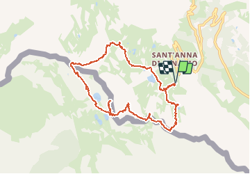
Trail Walking of 10.6 km to be discovered at Piemont, Cuneo, Vinadio. This trail is proposed by fredopaca.
Description
départ côté Italien santo di Anne ,vers pas st Anne ,cime Lausfer lacs laufer,col saboule
Positioning
Country:
Italy
Region :
Piemont
Department/Province :
Cuneo
Municipality :
Vinadio
Location:
Unknown
Start:(Dec)
Start:(UTM)
348778 ; 4898879 (32T) N.
Comments
Trails nearby
Châtaigneraie ISOLA
Walking
Very easy
(1)
Isola,
Provence-Alpes-Côte d'Azur,
Maritime Alps,
France
2h 9min
Yes
Isola 2000 baisse Druos refuge Quesa
Other activity
Very easy
(1)
Isola,
Provence-Alpes-Côte d'Azur,
Maritime Alps,
France
21 km | 35 km-effort
8h 5min
Yes
Tête Mercière
On foot
Easy
Isola,
Provence-Alpes-Côte d'Azur,
Maritime Alps,
France
8.1 km | 14.8 km-effort
3h 21min
No
(SI E13) Sant'Anna di Vinadio - Vinadio Frazione Strepeis
On foot
Easy
Vinadio,
Piemont,
Cuneo,
Italy
9.1 km | 16.1 km-effort
3h 40min
No
cime de la lombarde
Walking
Very difficult
(1)
Isola,
Provence-Alpes-Côte d'Azur,
Maritime Alps,
France
16.7 km | 31 km-effort
9h 25min
Yes
Cime de la Lombarde 2800m 26.8.24
Walking
Very difficult
Vinadio,
Piemont,
Cuneo,
Italy
3.4 km | 9.1 km-effort
2h 30min
Yes
Tour du Lausfer 25.8.24
Walking
Medium
Vinadio,
Piemont,
Cuneo,
Italy
9 km | 16.2 km-effort
3h 30min
Yes
Baisse druos
sport
Very easy
Isola,
Provence-Alpes-Côte d'Azur,
Maritime Alps,
France
9.3 km | 16.3 km-effort
Unknown
Yes
Vraiment pas facile pour débutants passage dans la neige sur flanc de montagne et que du chemin étroit